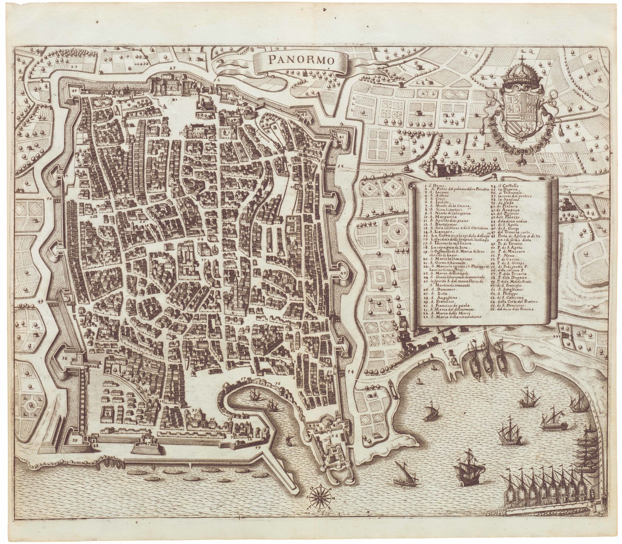
The first printed plan of the Atlantic frontier port of Angra in the Azores.
A Cidade De Angra. Na Ilha De Iesu Xpoda Tercera Que Esta Em 39 Graos.
$2,000
1 in stock
Description
An extraordinary bird’s-eye-view of the island of Terceira (Azores) and the town of Angra, produced at the end of the 16th century by one of the greatest proponents of the Golden Age of Cartography. Jan Huygen van Linschoten (1563-1611) was a Dutch merchant and explorer who spent years in the parts of Asia under Portuguese influence. He even served directly under the Portuguese Archbishop of Goa for a time. During his travels, Linschoten collected maps and other privileged information about trade and navigation in Southeast Asia and, in doing so, compiled a decisive and unique corpus of nautical and mercantile information.
Upon his return to Europe, this was converted into the famous Itinerario voyage ofte Schipvaert van Ian Hughen van Linschoten naer Oost ofte Portugaels Indien, which also contained an extensive collection of cutting-edge maps. The information derived from travelers like Linschoten marks the origin of Europe’s commercial expansion into India and Southeast Asia, eventually leading to the creation of the Dutch East India Company and the British East India Company.
The current engraving also comes from the Itinerario and is in part merited by the role played by the Azores in the crossing of the Atlantic Ocean. However, there is a personal element to this map as well, as Linschoten spent two years on Terceira compiling his notes and maps before returning to his native Holland and publishing his masterpiece. This map is thus a cartographic recreation anchored in first-hand experience, making it all the more interesting.
The Azores were the last stop before crossing the Atlantic (or indeed in the circumnavigation of Africa, which requires plotting a course west, in the Atlantic Ocean, before turning south and catching the Southern winds east to carry you past the cape), and the first familiar place ships would land when they returned home from the New World. Yet despite this pivotal role in early oceanic navigation, no mapmaker had previously put in the effort to provide the level of detail and artistry seen here.
Among the map’s many compelling elements is the fact that while it is a view of the island as a whole, and most of the mapped space constitutes field systems surrounded by volcanic ridges, it centers on the port of Angra in a way that makes the rest of the island appear to be little more than hinterland. As the island’s main port, Angra was naturally important, yet this was the first time a plan of the town was printed. The city stands out in the view, in part due to the regularity and structure of its planning. On the promontory to its right, we see São Sebastião, a traditional star-shaped Portuguese fortress. Structures of this type were constructed throughout the enormous sphere of Portuguese influence. Forts, however, quickly proved insufficient to sustain efficient trade, so new civilian and mercantile infrastructure needed to be added. To accomplish this, the Portuguese used Angra as a sort of urban model, meaning that, to a degree, the town was replicated in both Brazil and the East.
While Linschoten is famous for compiling much of the information in the Itinerario himself, he also had some of the best people working for him. In this case, the map was engraved by the famous Dutch engraver Baptista Van Doetichum and published through the cartographic printer Cornelis Claeszoon. In the upper left corner is a couplet in Latin by Pieter Hoogerbeets, followed by a medallion with the coat of arms of Portugal. In the center is the map’s title, and then on the right, we find two heraldic symbols of the Azores: her formal coat of arms and the Azor bird.
In the plaque hanging from the coat of arms, Linschoten dedicates the map to Cristóvão de Moura, a Portuguese nobleman who led the Spanish claim during the Portuguese succession crisis in 1580. The dispute led to the so-called ‘Spanish captivity’ of the Azores, which lasted from 1580 until 1642. Shortly after playing this decisive role, and perhaps in part as a reward, de Moura married Margarida Corte-Real, the heiress of the Captaincy of Angra, earning him a place on Linschoten’s map. At the bottom of the print are two further cartouches. The one on the left identifies the author and provides a date and a brief description of what is shown. This is the only text on the map written both in Latin and Dutch. The smaller cartouche on the right contains another Hoogerbeets couplet.
In compiling this gorgeous view, Linschoten broke with convention to create a cartographic masterwork. While he may have sold the view on its ornamentation and beauty, his assessment that Terceira and Angra were important enough to merit proper mapping should also be acknowledged. To this day, Angra do Heroísmo remains the main town on Terceira and among the most significant international ports in the Azores.
Cartographer(s):
Jan Huygen van Linschoten (1563 – 8 February 1611) was a Dutch merchant, trader, and historian who traveled extensively through the East Indies under Portuguese influence and served served six years as bookkeeper for the Archbishop of Goa (1583-89). He is credited with publishing important classified information about Asian trade and navigation that was kept as closely guarded secrets of the trade by the Portuguese.
In 1596, Linschoten published his Itinerario (later published in English as Discours of Voyages into Ye East & West Indies), which graphically displayed for the first time in Europe detailed maps of voyages to the East Indies, in particular the Indian Subcontinent.
Condition Description
Very good. Professionally backed.
References