A wonderful cartographic snapshot of the United States just as it annexed Texas.
Etats-Unis par Th. Duvotenay
Out of stock
Description
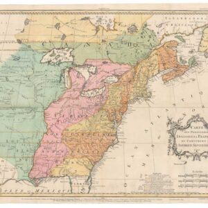
This charming little map depicts a young United States at a pivotal time in her history. Being an historical document available at a very reasonable price, this is the ideal piece for the early or young collector, just as it would serve as a meaningful graduation or birthday gift for anyone interested in history.
What makes this particular map so fascinating is of course its 1846 publication date, and the historical context that this date represents. It was produced at a time when the size and nature of the United States was changing dramatically. These changes are clearly reflected in the map, making it a great conversation piece.
A decisive development that has been documented by this map is the reentry of the Republic of Texas (1836-1846) into the Union, which happened the same year that the map was published. Texas is here portrayed as an integral part of the United States, although the vigilant viewer will nevertheless note that the westernmost part of Texas remains outside the state’s purview at this stage (delineated by the blue borderline). Soon this would all change and Texas would expand to more or less the dimensions we know today. It was the trigger behind this expansion that makes the current map so interesting and attractive.
In the two years following this map’s publication, the United States engaged in an uneven war against the recently independent state of Mexico. The Mexican-American war lasted only two years (1846-48) and resulted in the Treaty of Guadalupe Hidalgo, which was signed in February of 1848, but only took effect in September of that year. The treaty established the Rio Grande as the border for Texas and entailed the annexation of ‘Upper California’ by the United States. This enormous territory included not only the state of California, but also the areas of Nevada, Utah, Colorado, and most of New Mexico.
Therefore, this map was published in the dynamic period between annexation and the American victory in the war. In effect, this means that the lifespan of this particular representation was very brief, making it an excellent example of ephemeral dynamics that make maps such collectible congealments of history.
Cartographer(s):
Thunot Duvotenay (1796 – 1875) was a Paris-based French map publisher active in the 19th century.
Condition Description
Scattered foxing and minor blemishes.
References