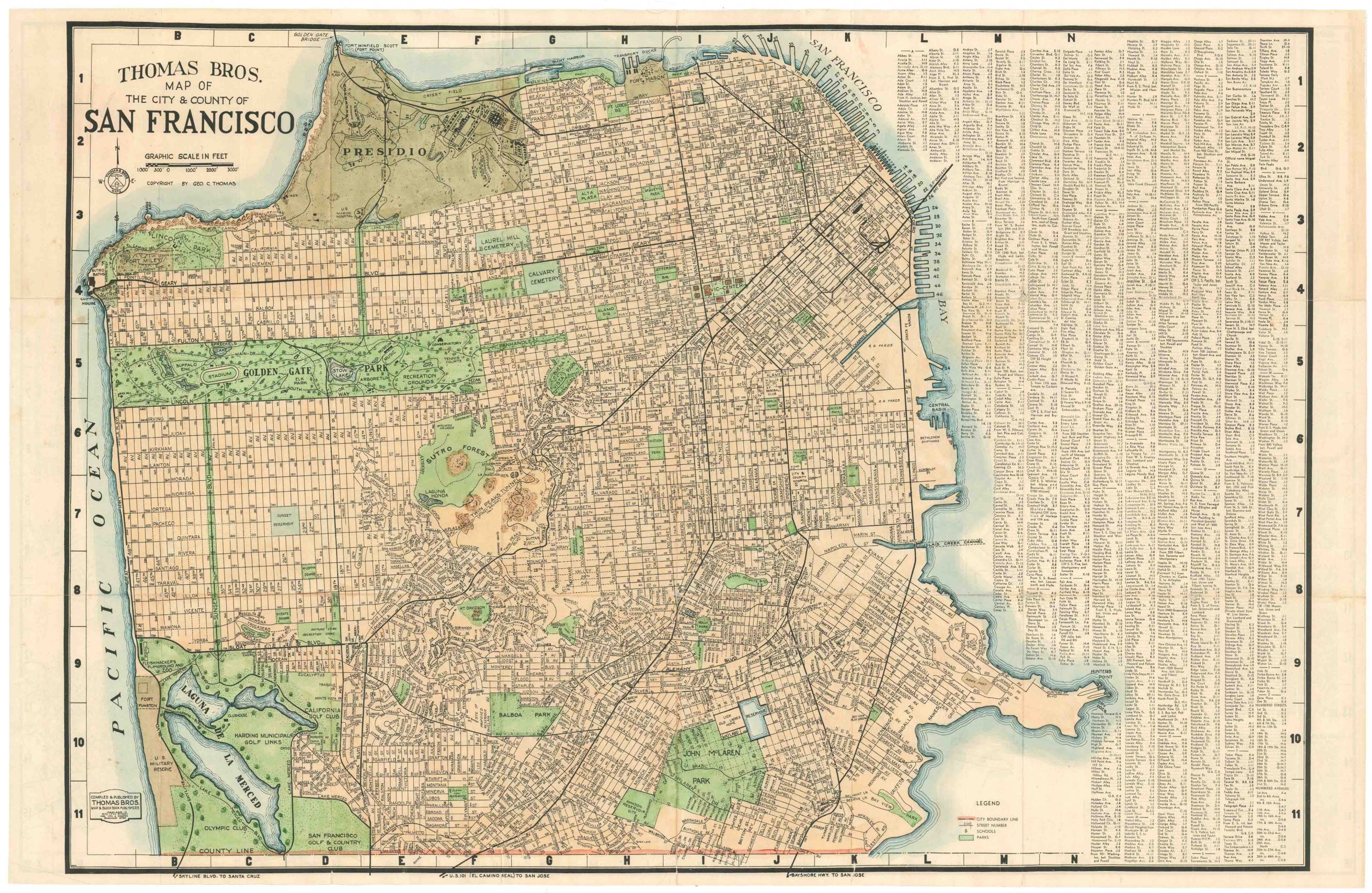
Chevalier’s famous map of San Francisco for the 1915 Exposition with original booklet.
The “Chevalier” Commercial, Pictorial and Tourist Map of San Francisco From Latest U.S. Gov. and Official Surveys. Designed-Engraved And Copyrighted By Aug. Chevalier, Lithographer Publisher, 507 Mission St. San Francisco.
$2,900
1 in stock
Description
This is the chromolithographic version of the famed Chevalier tourist guide, one of the most beautiful maps of San Francisco ever produced. It is based on a monumental wall map of the city first published by August Chevalier in 1903, which was reissued as our map in a smaller format and accompanied by a tourist guide for the Panama–Pacific International Exposition: the world’s fair held in San Francisco from February 20 to December 4, 1915.
The map uses a remarkable design to offer both intricate topographic and urban detail. For the natural features of the city, namely its famous hills and parks, Chevalier has employed a hybrid of elevation lines, shading, and colors. In bold contrast, red overprinting delineates new district names, trolley lines, and proposed tunnels and railcar extensions.
At the same time, important buildings are depicted in pictorial profile, making them stand out from the page. This includes major monuments and buildings in Golden Gate Park, around the Civic Center and Financial District, and along the waterfront, including piers and Fisherman’s Wharf. And of course, the Panama–Pacific International Exposition itself is featured in the same detail. The fair’s stated purpose was to celebrate the completion of the Panama Canal, but it was widely seen in the city as an opportunity to showcase its recovery from the 1906 earthquake. The fair was constructed on a 636 acre site along San Francisco Bay, between the Presidio and Fort Mason, the neighborhood now known as the Marina District.
Overall, the combination of cartographic ingenuity and beauty, along with its importance as a document of the 1915 World’s Fair, makes this an exceptional San Francisco map.
Cartographer(s):
August Chevalier was a San Francisco–based lithographer and publisher active in the late 19th and early 20th centuries, best known for his pictorial and promotional maps of the city. His work is characterized by its distinctive blend of cartography and illustration: hills are shaded with almost painterly attention, while major buildings, landmarks, and civic institutions are rendered pictorially. This hybrid style made his maps both practical guides and compelling visual records of a rapidly expanding metropolis. His celebrated large-format chromolithograph maps of San Francisco, issued in multiple editions, are among the most recognizable cartographic views of the city from the period.
Chevalier’s maps were not only decorative but also deeply tied to the civic identity and boosterism of San Francisco. Produced for both residents and visitors, they highlighted new infrastructure, civic architecture, and cultural amenities in a city eager to project itself as the “Gateway to the Pacific.” By the time of the 1915 Panama-Pacific International Exposition, Chevalier’s cartographic style had become part of the city’s visual language, shaping how locals and visitors alike navigated and imagined San Francisco. Today his works are valued not just for their artistic merit, but as vital historical documents of a city reinventing itself in the decades after the Gold Rush, the 1906 earthquake, and the triumph of the Exposition.
Condition Description
Very good. A couple splits at fold intersections. Folded into accompanying booklet. Someone has marked a spot on the map in pen with an 'X' and two lines.
Folds into original booklet.
References
Rumsey 5865.002. OCLC 28943362, 953568824.
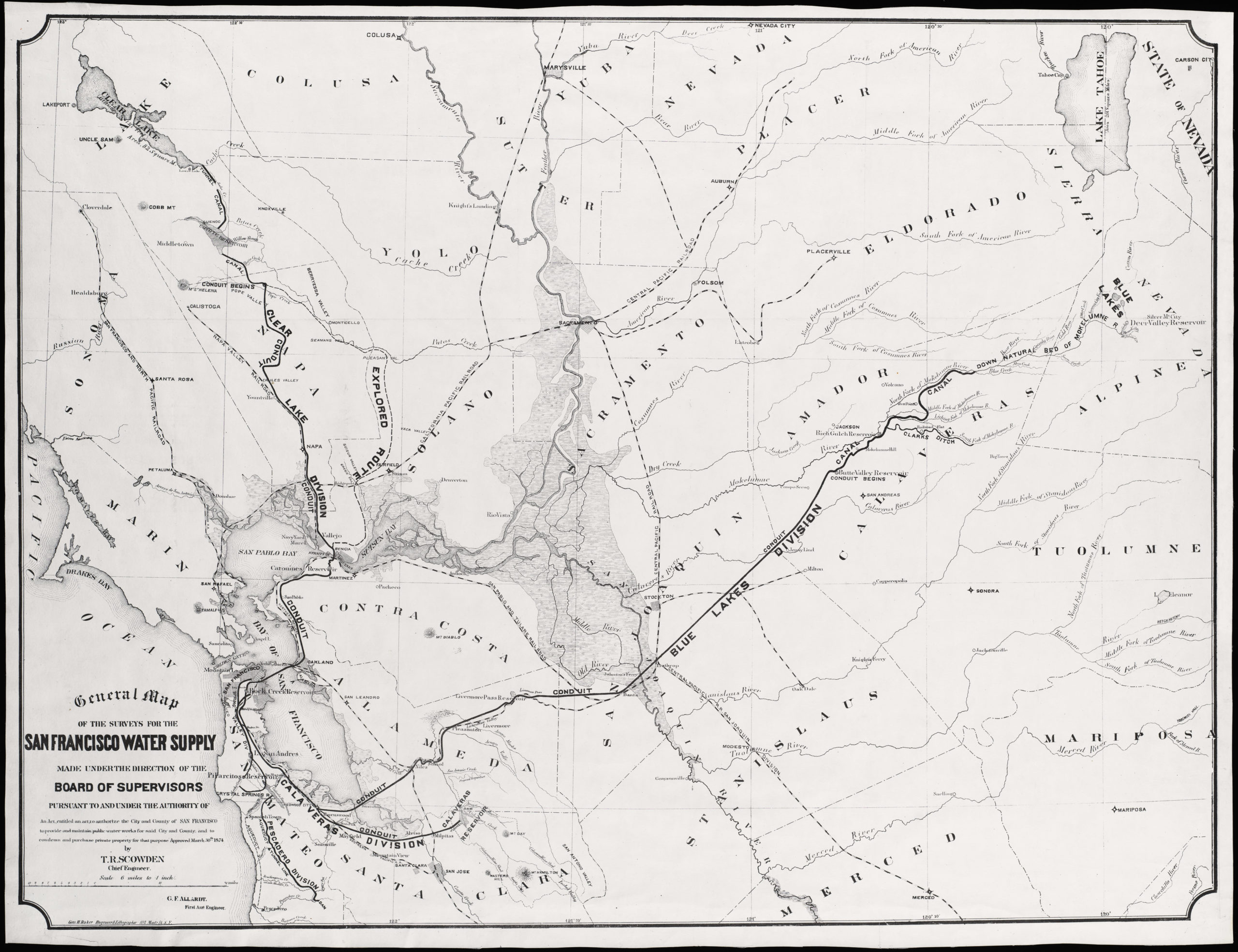
![5-sheet set showing San Francisco’s post-1906 earthquake water supply [SF’s first fireboat!]](https://neatlinemaps.com/wp-content/uploads/2022/03/NL-01375-sheet-4_thumbnail-scaled-300x300.jpg)
![5-sheet set showing San Francisco's post-1906 earthquake water supply [SF's first fireboat!]](https://neatlinemaps.com/wp-content/uploads/2022/03/NL-01375-sheet-4_thumbnail-scaled.jpg)