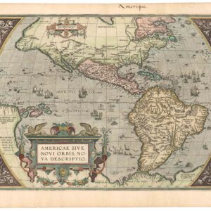
Henricus Hondius’ iconic 17th-century map of North America: an entirely new cartographic vision of the continent.
America Septentrionalis [First State, Original Color]
Out of stock
Description
This spectacular and early view of North America, compiled by the influential Dutch cartographer Henricus Hondius and engraved by his partner and brother-in-law, Jan Jansonius, reflects how advanced Dutch map-making was in the early 17th century. This folio sheet was one of the first printed maps to capture North America independently and in the thralls of early colonization and was key in promoting the myth of the Island of California.
This example is the rare first state of the map, issued in 1636. This can be verified by the empty cartouche in the lower left of the map, which from the second state onwards is filled with the words: “AMSTELODAMI, Excudit Ioannes Ianßonius.”
Hondius’ map shows an early colonial America still largely unexplored and full of mystery and promise. The pioneer spirit is tangible in the map’s decoration, and the information conveyed. Among the decorative elements, the most prominent are the vignettes of local chieftains surrounding the title cartouche in the upper left corner, obscuring the unknown Northwest Pacific, which even lacks a coastline — this was truly Terra Incognita. We find no hint of the Great Lakes, just as there is no inkling of America’s riverine backbone, the Mississippi.
The mapmaker depicts an abundance of fauna, including foxes, bears, deer, whales, wild boar, antelopes, and a type of wild oxen, quite possibly an early representation of bison. In the empty interior, ample space is also used to annotate some of the most recent discoveries and their implications. This includes new toponyms given by explorers in the north, especially around Hudson Bay.
In general, the map is rich with evocative place names. Along the East Coast, we find Nova Belgicum, which is labeled with Dutch terms like eylant (island) or punt (point). And further south, anyone interested in early colonial history will, of course, be looking for Jamestown, the first permanent settlement established by the British in Virginia, which is also clearly represented.
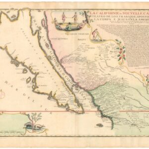
Also present are a range of critical geographic features, each of which will become prominent in the mapping of North America over the coming century. The rendition of California as an island is one of the great cartographic myths in mapping America and a popular collecting trope. In dealing with this particular chart, Phillip Burden, a world-renowned expert on early maps of America, has described it as ‘the single most influential map in perpetuating the myth of California as an island.’
In addition to California as an island, the map offers many other details that soon penetrated onto a broad array of both continental and regional maps of America. In southern California, for example, we see a major river labeled Rio del Norto extending inland to a large interior lake that may well be one of the first cartographic representations of the Great Salt Lake in modern Utah. A famous lake at the time is found in South America, where the Parime Lacus already for some time had been associated with the fabled city of Eldorado.
In both cases, these themes would be taken up by the era’s great French cartographers. Seminal mapmakers like Nicolas Sanson became heavily inspired by the clear-cut delineations of Hondius and other Dutch forbears. In the waters surrounding the American landmass, we find both ships and sea monsters, most of which seem decorative. The decision to place one ship in the Hudson Bay and another north of California may constitute a demarcation of these regions as frontiers of exploration and discovery.
The map is not only a testimony to the relentlessness and courage of early colonization but also the compiling genius of Henricus Hondius. This map was created by bringing together a range of the best cartographic sources at the time and allowing their amalgamation to create something new and fresh. Among the sources Hondius used, we recognize Hessel Gerrtisz’s chart of Florida and the Gulf of Mexico (1631) for the south and Henry Briggs’ The North Part of AMERICA (1625) for large parts of the West. For the Northeast and Virginia, Hondius drew on early British mapmakers like John Smith and explorers like Luke Foxe, Thomas James, John Davis, and Henry Hudson himself.
Being the cartographic genius that he was, Hondius was not only able to combine the data from these sources into an elegant new composition, but in the spaces where he did not have adequate or reliable source material, he was bold enough to use what little he had to compile his sections. In this map, the East Coast between Virginia and Florida is one such wholly original composition, which can be attributed to Hondius himself.
Cartographer(s):
Henricus Hondius (1597-1651) was a Dutch engraver and cartographer and a member of a prominent family of mapmakers and publishers in Amsterdam. His father, Jodocus Hondius, an engraver and geographer, had purchased part of the estate after Gerhard Mercator. Henricus was instrumental in the first Hondius edition of Mercator’s 1595 atlas (1606). When the father died in 1612, the family business was passed on to him and his brother, Jodocus the Younger. They ran the firm together for nine more years until Henricus decided to venture out independently.
Family ties remained close, and in the early 1630s, Henricus joined forces with his brother-in-law (husband to his sister), the highly skilled engraver Johannes Jansonnius. Together, they recreate and expand the Mercator atlas to such an extent that its contents since have come to be classified as Mercator-Hondius-Janssonius maps. Henricus Hondius died in Amsterdam in 1651.
Jan JanssoniusJohannes Janssonius (1588 – 1664; born Jan Janszoon, also Jan Jansson) was a Dutch cartographer and publisher who lived and worked in Amsterdam in the 17th century. Janssonius was born in Arnhem, the son of Jan Janszoon the Elder, a publisher and bookseller. In 1612 he married Elisabeth de Hondt, the daughter of Jodocus Hondius. He produced his first maps in 1616 of France and Italy.
In the 1630s, Janssonius formed a partnership with his brother-in-law Henricus Hondius; they published atlases as Mercator/Hondius/Janssonius. Under the leadership of Janssonius, the Hondius Atlas was steadily enlarged. After Janssonius’s death, the publishing company was continued by his son-in-law, Johannes van Waesbergen. The London bookseller Moses Pitt attempted publication of the Atlas Major in English but ran out of resources after the fourth volume in 1683.
Condition Description
Paper evenly age-toned, with some foxing. Minor repairs in margins. Old color.
References