A largely unrealized proposal for highways through San Francisco.
A Report to the City Planning Commission on a Transportation Plan for San Francisco – November 1948
Out of stock
Description
This is a fascinating 1948 transportation plan proposed to the San Francisco City Planning Commission by the engineers De Leuw, Cather, and Company and the city planners Ladislas Segoe and Associates. It was produced at a time when the use of public transportation was plummeting, replaced by privately-owned automobiles. As the report highlights, the population of the Bay Area was also increasing rapidly in these years, necessitating new infrastructure to meet increased transportation demand.
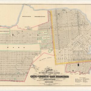
The report includes more than 50 graphs, charts, and maps, with many of the maps being fold-out schematics of proposed freeways. At the back is a large foldout map of the entire proposed transportation plan. Portions of the proposed plan match neatly with San Francisco’s current highway and road system, especially those that were already partially completed or planned when this report was published, such as the Broadway Tunnel and the Bayshore Freeway (US-101).
Among the unrealized proposals was a north-south Central Freeway largely following the course of Van Ness Ave, a highway through the Mission District (Mission Freeway), a second transbay crossing (bridge or tunnel) for automobiles to the south of the Bay Bridge, and a highway along the Golden Gate Park Panhandle that split into two short highways reaching the Sunset and Richmond Districts. More speculatively, potential future connections included an expressway along Geary Boulevard, a north-south expressway through Inner Sunset and Forest Hill, and two connections between the Embarcadero and Van Ness meeting at Lombard Street and then connecting to the Golden Gate Bridge (the whole route sometimes dubbed the Golden Gate Freeway).
Some of these ideas were embraced by a 1955 transportation plan (“Transportation Section of the Master Plan of San Francisco”), which found partial realization in the form of the Embarcadero Freeway (SR-480). The first section of the double-decker freeway connecting the Bay Bridge to Broadway opened in 1959, by which time neighborhood resistance to highways had increased significantly. In 1964, some 200,000 people rallied in Golden Gate Park against proposed new freeway construction in the city. The following year proposals for the Panhandle Freeway and Golden Gate Freeway were definitively killed off.
Among other concerns, the Embarcadero Freeway was especially loathed by local residents for blocking views of and access to the bay and the Ferry Building. Groups of voters and activists repeatedly attempted to have it slated for destruction. When the freeway was damaged in the 1989 Loma Prieta Earthquake, then-Mayor Art Agnos presented the damage as an opportunity to be rid of the highway, and it was demolished in 1991. One prominent defender of the Embarcadero Freeway was the Chinatown community activist Rose Pak, who opposed Agnos and helped to defeat his reelection campaign in 1992. With the freeway closed, Pak successfully lobbied to have a subway line built to Chinatown, realized with the opening of the Central Subway in 2022.
Aside from freeways, a section of the plan deals with rapid transit, which mostly prioritizes buses using the new expressways, enjoying separate right-of-way and dedicated “subways” for faster travel. However, a subway in the sense of electrified train cars was proposed to run along Market Street, through the Twin Peaks Tunnel, and along Portal Avenue towards Lake Merced, roughly the course taken by today’s MUNI M Line. Additional future lines were considered, including a line through the Mission District that roughly follows the route later taken by BART.
This report was published in 1948 in a limited run and is today held by around 20 academic libraries in the United States and abroad.


Cartographer(s):
Condition Description
Stenciled typescript, various paginations, on rectos only. With numerous maps and plans, most folding, many in color; plus graphs, tables etc. Glossy printed wrappers, cloth spine. Foxing and discoloration on the cover, water damage to top of back cover, text is clean with some wear to the edges.
References


![5-sheet set showing San Francisco’s post-1906 earthquake water supply [SF’s first fireboat!]](https://neatlinemaps.com/wp-content/uploads/2022/03/NL-01375-sheet-4_thumbnail-scaled-300x300.jpg)
![5-sheet set showing San Francisco's post-1906 earthquake water supply [SF's first fireboat!]](https://neatlinemaps.com/wp-content/uploads/2022/03/NL-01375-sheet-4_thumbnail-scaled.jpg)