1853 Zakreski San Francisco letter sheet map with personal notes.
The only correct & fully complete map of San Francisco
Out of stock
Description
Some of the most exciting items of San Francisco cartographic ephemera were letter sheets issued by local printing firms. In this case, we have an extraordinary survival: a letter sheet on green paper with a map of San Francisco from 1853. The map was drawn by one of early San Francisco’s most important surveyors, Alexander Zakreski, and Zakreski’s printing firm lithographed the letter sheet.
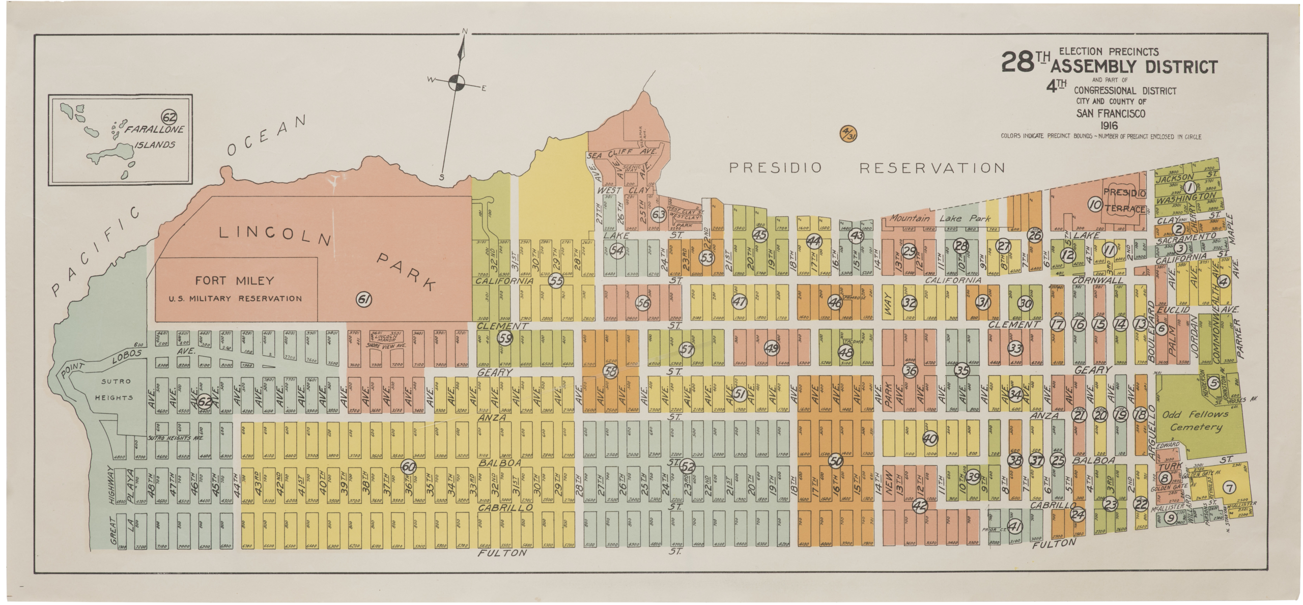
The map itself was printed both in standard map form and as a letter sheet. It is oriented north at the top. Its scope is centered on the old harbor of Yerba Buena, which in the previous five years saw a transfer of power from Mexico to the United States, its renaming to San Francisco, and a population explosion resulting from the Gold Rush. Part of the city’s expansion was facilitated by the sale and infilling of water lots, effectively pushing the coastline further into the Bay. Zakreski documents this process by delineating the original shoreline, well inland from the planned city. The waters of the Bay were deeper offshore, and city officials designed and constructed a new series of piers and wharves to facilitate the movement of people and goods. The waterfront area of North Beach would, of course, become today’s Fisherman’s Wharf.
A few other (of many) key details include the plots of the mysterious Laguna Survey in the upper right of the map, with its off-axis orientation. Running past it to the north is the proposed supply line of the Mountain Lake Water Company. Keen observers and students of San Francisco history will also notice Spark’s Claim. This label appears on very few historical maps of the city. It refers to an obscure sale of land belonging to formerly owned by Hervey Sparks, Esq., one of the most prominent pre-statehood San Franciscans.
The area of today’s City Hall Plaza is still shown as a Yerba Buena Cemetery, one of several cemeteries that were eventually relocated outside the city limits.
Census
OCLC lists one holding of the regular published map and none of this letter sheet version. Letter sheets were produced to be used and mailed; thus, very few have survived.
Our particular example has a remarkable personal touch: someone has detailed his or her living arrangements in the city through several lines in manuscript ink and markings on the map itself.
Letter sheets as an ephemeral historical record
A letter sheet is a philatelic term for a sheet of paper that can be folded, sealed, and mailed without the use of an envelope. These sheets were often embellished with lithographed images taken from an artist’s sketchbook or a photographer’s daguerreotype. Letter sheets can thus be considered a precursor to the popular postcards of the 20th century. Letter sheets exist in various forms, but we can generally distinguish them into two categories: stationery issued by postal authorities and that produced by private firms.
Letter sheets of all types enjoyed great success in the 1850s and 1860s. With the California Gold Rush and its influx of new people to remote regions, miners began sending letters back home in droves. During the Civil War, letter sheets were a popular means of communication between enlisted men and their families. The need for them was so prescient that in August of 1861, the United States government issued two different sizes of letter sheets, each with the necessary 3-cent stamp imprinted on them.
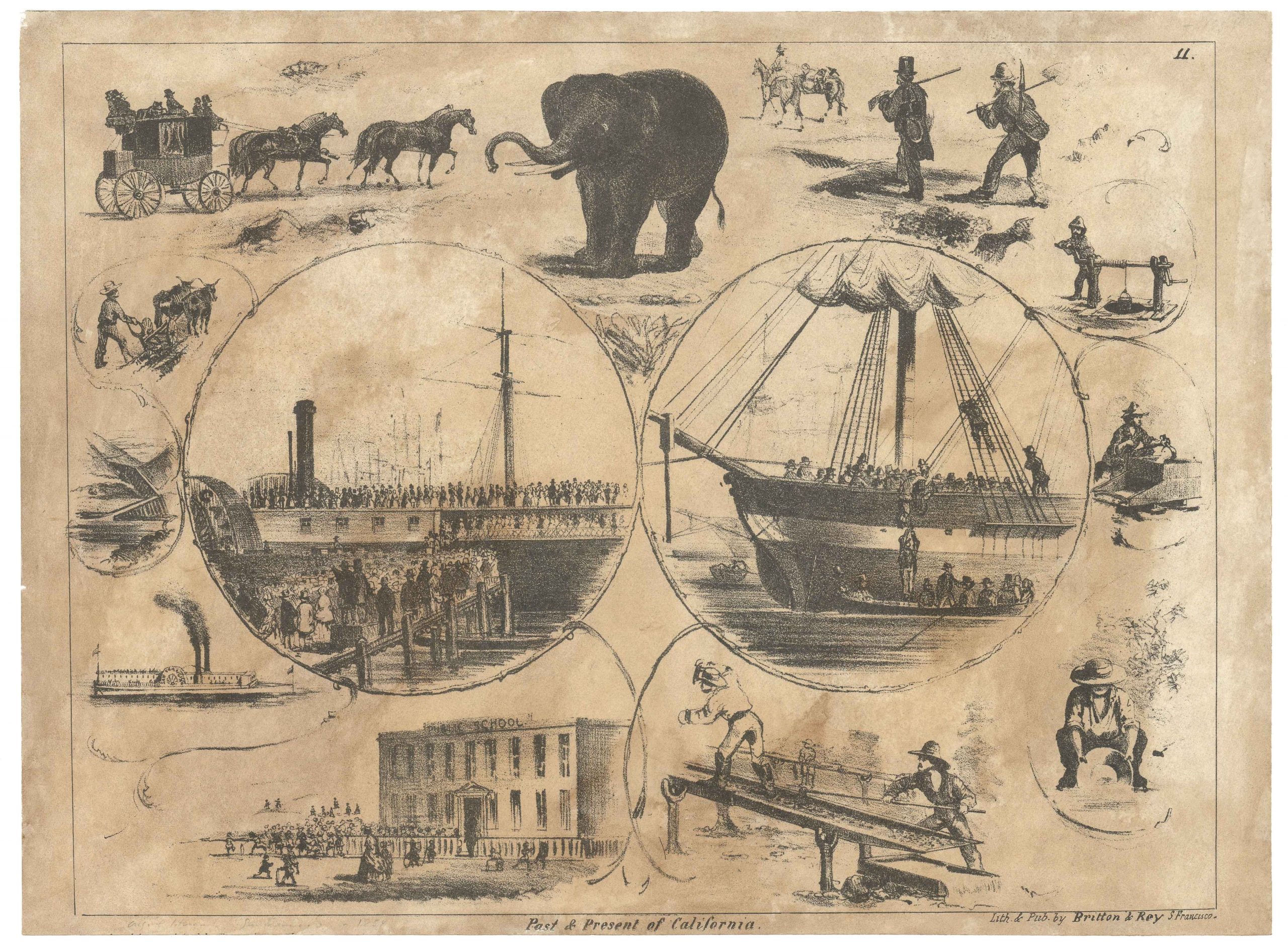
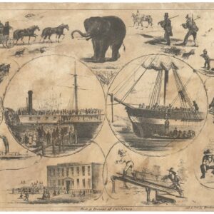
Many private firms saw in letter sheets the possibility of a steady income and a means to promote their printing business. For miners and soldiers, letter sheets were cheap and practical and, in many cases, had the added benefit of sharing a visual impression of places or events witnessed with family and friends. While the design of letter sheets is as diverse as the imagination allows, city views were a common subject. Such views enticed imaginations and spread impressions of cities across a young nation, where only a few had access to any kind of visual media. In many cases, letter sheets gained an added dimension because they were used and thus contextualized.
One of the most popular subjects was San Francisco. Following the Gold Rush boom in people and investment, the city had become a magnet for emigrants from the East Coast and Europe. San Francisco’s rapid growth and its reputation as a boom town were among the things that attracted a significant number of printers and artists to the city in the 1850s and 60s. Most of these firms produced their own lithographed letter sheets, sometimes replicating much grander views that these printers would also produce, other times creating something entirely new or scene.
In addition to mining scenes, common topics among the San Francisco printers included views of the city; dramatized scenes of catastrophes like the 1906 earthquake and fires; natural wonders like the great redwoods; views of inland towns like Sacramento, Springfield, or Sonora; and notable events such as public executions. Others built more on atmosphere or romanticized concepts of the frontier. Such images included wagon trains pushing across the prairie or mountain men fighting grizzly bears. Sometimes, letter sheets even contained maps of cities, counties, or states.
The heyday for the production of letter sheets in and about San Francisco was between 1849 and 1875. Urban views and mining themes were prevalent. The many scenes associated with mining and prospecting in California have come to represent one of the largest and most significant visual records for historians working on the Gold-Rush era. Because of their historical significance and the diversity of their subject matter, collectors have long prized letter sheets. Furthermore, due to the low quality of the paper used, most of them have perished over time, making those that have survived an increasingly rare commodity.
Cartographer(s):
Alexander Zakreski (1799-1866), was born in Poland but ran afoul with Russian authorities and was forced to flee to France. Events of the Revolution of 1848 again compelled him move on, this time to San Francisco, where he arrived in 1850.
Zakreski was a talented engineer and surveyor, skills he put to work as one of the newly booming city’s most important cartographers.
Condition Description
Good. Verso repairs to previous loss along fold lines and in margins. Even toning.
References