Felix Jones’s map of Nineveh: the first modern cartographic visualization of Assyria’s great capital.
Vestiges of Assyria. Sheet lst an Ichnographic Sketch of the remains of ancient Nineveh with the enceinte of the modern Mosul.
Out of stock
Description
Showing some of the most important excavations in the history of archaeology.
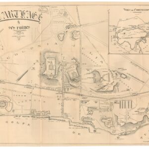
This excellent map is the first trigonometrical survey of the environs of the great Iraqi city of Mosul. Executed by British officers at the height of the Victorian Era, it depicts the landscape of ancient Nineveh, the largest and most infamous of mighty Assyria’s royal capitals (from 705-612 BCE). The map is the first of three large sheets produced in 1852 by Commander James Felix Jones (1813-78). It highlights the seminal excavations of Austen Henry Layard, which produced a series of stunning finds, including tablets relating to the Epic of Gilgamesh and stories of a Great Flood that predate the Bible.
Scholar and Commander
Felix Jones was a veteran of Middle Eastern affairs serving in Mesopotamia under the East India Company. Along with Robert Moresby, he charted the northern part of the Red Sea between 1829 and 1834. A decade later, the British Army in India sent him to northern Iraq to help resolve a border dispute between Persia and the Ottoman Empire. Accompanying him on this journey was Sir Henry Rawlinson: also a British Army officer, but more importantly, a renowned Orientalist scholar who had made a decisive contribution to deciphering Semitic cuneiform languages like Akkadian, Babylonian, and Assyrian. In northern Iraq, Jones and Rawlinson experienced many of the ancient cultures and languages that Europeans only knew from the Bible. Uncovering their secrets soon became a key part of the Victorian thirst for aligning new knowledge with old beliefs.
Rawlinson inspired Jones with stories of the ancients and Jones found the archaeological landscapes so compelling that he returned in 1852 to map them formally, dedicating the outcome of those surveys to Rawlinson and other patrons. When Jones returned as the head of a British survey team in 1852, the goal was to execute the first exact trigonometrical survey of a landscape deeply rooted in Biblical tradition. He focussed his effort on the royal cities of Nimrud and Nineveh, as well as the densely settled plain between the Tigris and Jebel Maglub.
Jones’s initial journey to this region is key to understanding the motivation behind his wonderful maps. Rawlinson’s decisive contribution to understanding ancient civilizations had been deciphering the Old Persian part of a trilingual cuneiform inscription carved on a rock face at Bīsitūn in Iran. The accomplishment was as seminal as the discovery of the Rosetta Stone and the deciphering of Egyptian hieroglyphs, in part because it spoke to a generation of soldier-scholars determined to demonstrate the Bible’s veracity through modern science.
The groundbreaking excavations of Austen Henry Layard
Complimenting Rawlinson’s translation work and Jones’s maps were Austen Henry Layard’s incredible archaeological discoveries at Nineveh in the 1840s. Layard initiated large-scale excavations of the two main mounds on the eastern bank of the Tigris, where he uncovered the magnificent palaces of Assyrian kings, including those of Biblical characters like Sennacherib, as well as the libraries and royal archives of this lost civilization. It was the discovery of the century, and Rawlinson’s work on the cuneiform language gave scholarship an entirely new kind of access to history. For many, this was more tangible than exploring the Exodus route taken by the Israelites in the Sinai.
Jones executed his surveys according to the British Army’s highest standards, which implied meticulousness and clarity. Layard’s excavations have been carefully marked in bright red, although the actual buildings he discovered are not directly represented. Also visible are numerous features, buildings, and villages surrounding Nineveh and Mosul. Some of these are as ancient as the Assyrian capital itself, while others are contemporary Ottoman sites. The second map depicts the area surrounding the other Assyrian royal capital, Nimrud, which was located some thirty kilometers downriver from Nineveh. A third map – also offered by Neatline – scales back the view to include the entire archaeological landscape surrounding both royal capitals.
Jones annotates the maps extensively. Most labels are in English, but the map also includes exotic-looking toponyms in Arabic and Cuneiform for dramatic effect. We see the contemporary city walls of Nineveh clearly delineated in dark red on the map, allowing us to visualize the relationship between the ancient city, the modern city, and the river that sustained them both. Today, Mosul has swallowed up the ancient ruins entirely.
Within the walls of the ancient imperial city are the two central mounds excavated by Layard, labeled Koiyunjik and Nebbi Yunus. These are the main palace and temple areas in the city. The physical elevation in the landscape is the direct result of extensive building and habitation in these particular spots over a very long period of time. The bright red markings denote the areas excavated by Layard and his team up until this point. The excavated areas included the palace of Sennacherib and his library (or imperial archive), which contained more than 30,000 clay tablets that recorded some of history’s most essential ancient texts.
Among the seminal literary discoveries was the Epic of Gilgamesh, which, already in Assyrian times, constituted an ancient mythology that stretched back for millennia. The Gilgamesh Epos is not only the earliest coherent mythology in humanity but includes stories mirrored in the Bible, such as the great flood. Excavating these sites and subsequently deciphering and translating the texts revolutionized how we understood our civilizational origins. Even today, Nineveh is ranked as one of the most important archaeological discoveries of all time. The vast majority of the finds from Layard’s excavations are still held in the British Museum.
Like Jones’s other two Assyrian charts, the map was lithographed in color and issued in a dissected form laid on linen. All pertinent information is printed on the map itself, including dedicatory notes and the facsimile signature of the mapmaker. In keeping with the general Orientalist style and atmosphere, the map is framed by a border complete with Assyrian-style motifs (as revealed by Layard). It includes text in Cuneiform, Arabic, and Greek. It is a compilation that speaks both to academic curiosity and romantic historicism.
Conclusion
Ultimately, this map is the product of an age in which Europeans expanded their sphere of political influence alongside their intellectual horizons. The Victorian Age produced a plethora of gentlemen- and lady scholars who traversed half the known world in an attempt to improve humankind’s understanding of who we are and from where we come. The early archaeological exploration of the Middle East was a quintessential part of this drive, and nothing emboldened and stimulated it more than Layard’s discoveries in Northern Iraq. Jones’s maps are the cartographic manifestation of those discoveries, as well as of the fervent excitement that lay behind them.
Census
Felix Jones’s Vestiges of Assyria maps three maps are remarkably rare – both on the market and in institutional collections.
In American institutional collections we find holdings of all three maps at Harvard, University of Chicago, University of Wisconsin, and UCLA (OCLC nos. 31005511; 1252227018). A copy of all three maps is also held at the Metropolitan Museum of Art (OCLC no. 77739975).
Individual examples of the first sheet can be found at the Bibliothèque nationale de France (OCLC no. 495080532) and Leiden University Library (OCLC no. 71568777). Individual examples of the third sheet are held at Leiden University Library (OCLC no. 71568786), Universitätsbibliothek J.C. Senckenberg in Frankfurt (OCLC no. 174745220), and the Landesbibliothek des Sachsen-Anhalts (OCLC no. 1308805668).
Cartographer(s):
Felix Jones (1813-1874) was a British Commander in the Indian Navy and an employee of the East India Company. At only fourteen, he joined the Bombay Marine and soon became involved in British surveying projects in the Middle East. He served as a midshipman on the RIMS Palinurus, a 444-ton survey vessel launched in 1807 and belonging to the Royal Indian Marine. During its mission, the ship surveyed the large tracts of the Red Sea littoral.
In the 1820s, Jones moved on to serve on the first British survey of the Persian Gulf. This survey was necessary because the Gulf’s waters were treacherous and British ships were reluctant to sail to its head for commercial purposes. The survey began in 1820 near Oman and gradually worked its way north. It was completed under Stafford Bettesworth Haines in 1829, and Jones was an essential surveyor on the last leg of the mission. Haines has won some infamy as the EIC officer that secured Aden for the British.
After some years of service, Jones returned to the Middle East in 1839 to survey the harbor of Kuwait. Having built up considerable knowledge and experience in the Middle East at this stage, Jones continued to serve the Indian Navy as a surveyor in the Middle East, retiring in 1862 as Political Agent in the Persian Gulf. Historians have argued that Jones, in this capacity, played a central role in planning the British Invasion of Persia in 1856-57.
John WalkerJohn Walker was a British map seller, engraver, lithographer, hydrographer, geographer, draughtsman, and publisher of both nautical charts and geographical maps. Walker’s maps for publication were primarily produced in partnership with his brother, Charles, under the imprint J. and C. Walker. Among their joint projects were more than 200 maps for the influential Society for the Diffusion of Useful Knowledge Atlas (SDUK). In addition they published numerous charts for the Admiralty Hydrographic Office.
Condition Description
Excellent.
References