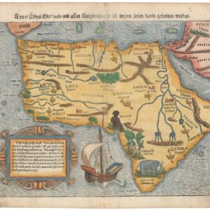
Jules Hansen’s seminal map of colonial Africa.
Société de Géographie de Paris AFRIQUE 1895
Out of stock
Description
Jules Hansen’s impressive map of an almost completely colonized Africa was a landmark in the mapping of the continent and served as the French government’s go-to source during the late 19th century’s ‘Scramble for Africa.’
This large format map of Africa was published a decade after the so-called Berlin Conference (1884-85). It delineates the many territorial claims made by European nations at the time – in particular countries like Great Britain, France, and Belgium, but also wannabe colonizers such as Russia, Germany, Denmark, and the United States. Its compilation was a step in the French mapping of Africa. Indeed, for years after its publication, Hansen’s Afrique served as one of the main cartographic visualizations of the French government’s involvement in Africa.
The map aims to show how Africa had been carved out between its European colonizers. To this end, Hansen used color coding and ample labeling to show which European empires dominated which parts of Africa and how the territories could be distinguished. Such delineations also highlighted “unclaimed” territories for the European nations still just getting into the game. Explicitly colonial language is pervasive; for example, South Africa is labeled Colonie du Cap.
From the territorial divisions and labeling, we note how colonizing nations such as Britain and France aimed at building enormous and coherent swathes of land. By the end of the 19th century, British claims on African territories extended from their old Cape Colony established in 1795 to more recent acquisitions around the Rift Valley – especially in today’s Kenya and Tanzania today.
British holdings would have continued all the way up to Egypt and the Mediterranean had it not been for Africa’s new colonizer and the host of the Berlin Conference: Bismarck’s Germany. The Germans were late to the game, but in light of their growing power in Europe, they were not afraid to demand a piece of the pie. Most of Germany’s holdings were concentrated in East Africa, causing British interests and colonial connectivity to be somewhat compromised.
On the other hand, the French were clearly the dominant force in North Africa and the sub-Saharan Sahel region. As French influence grew, they challenged British hegemony over Egypt by pushing into Nubia and Upper Egypt in 1898 – a process documented by later states of Hansen’s map. Despite the growing influence of colonial powers and the advancements in the technologies associated with exploration, we still find large, unexplored regions, especially in the Sahara and Central Africa.
Context is Everything
Between 1885 and 1895, the continent’s political face changed dramatically in a process known as the ‘Scramble for Africa.’ In many ways, the scramble began in the Berlin conference halls of Berlin. The current map is therefore best viewed as a cartographic manifestation of the political consensus reached at this historic event.
The Berlin Conference, also known as the Congo Konferenz or West Africa Konferenz, was organized and held in the German capital between 1884 and 1885. The official purpose was to agree on the regulation of European colonization and trade. This climax in the age of colonization is known as the New Imperialism period. Part of the reason for its emergence was Germany’s unification into a single empire in 1871 and the subsequent demands Germany would make on the world stage.
The conference was organized by Germany’s first chancellor, Otto von Bismarck, and indicated that Germany now entertained colonial ambitions in Africa. Present at the meeting were no less than fourteen nations, each with their own agendas in the great continent. While the majority were European nations, non-European entities such as the United States, Russia, and the Ottoman Empire were also present. Of the fourteen, almost half the countries (i.e. Austria-Hungary, Russia, Denmark, the Netherlands, Sweden–Norway, and the United States) left the conference empty-handed.
Many historians view the ‘General Act’ that emerged from the conference as a formalization of the complete colonial partitioning of Africa. Whatever the case, the event ushered in a new period of colonial expansion in which multiple parties participated. The process wiped out what was left of indigenous political autonomy and distended colonial rule into the continent’s most remote areas. Often, countries pushed further than was practical to ensure that as much land came under the national bonnet as possible. The intensity of the process, and the fact that so many countries participated in it, is why it has come to be termed the ‘Scramble.’
Census
The OCLC identifies examples of this particular map in the Bibliothèque nationale de France (no. 1176781897), the Boston Atheneum, and the university libraries at Yale, Stanford, Minnesota, and UCLA (no. 643084893). Later states of the map can be found in a number of institutional libraries throughout the United States.
Cartographer(s):
Jules Hansen (1849-1931) was a Danish cartographer born in Paris, where he also studied surveying techniques and geography. In 1876, he became a member of the Societé de Géographie, which published many of his maps over the next two decades. Hansen had a particular focus on Africa, and within the framework of the Society, he gained unique insights into the great continent. He befriended members of the French Congo Expedition (1885), and in 1889, he was appointed the official cartographer for the French Ministry of the Colonies.
Among Hansen’s most remarkable cartographic achievements was mapping the Middle Niger River and the mysterious Upper Nile. He also issued a map of Madagascar, which included the routes taken by various French expeditions to explore the island. The most seminal achievement of Hansen’s career was nevertheless the publication of his grand Africa map at a scale of 1:10,000,000 in 1895. This map was a key document for French interests in the Scramble for Africa and was updated yearly until 1899 to incorporate the latest discoveries and political developments.
Condition Description
The map is segmented and backed with the original publisher's linen and comes in its originally issued in its original gold-embossed slip-case.
References
![[South Africa] Photograph panorama of Cape Town, c. 1870](https://neatlinemaps.com/wp-content/uploads/2022/09/Screen-Shot-2022-12-18-at-11.22.15-AM-300x300.png)