Whitney’s iconic 1890 map of Seattle: the Emerald City in its infancy following Washington statehood.
Whitney’s Map Of Seattle And Environs, Washington. Compiled From Official Records By O.P. Anderson And Co. Engineers and Draughtsmen. 1890.
Out of stock
Description
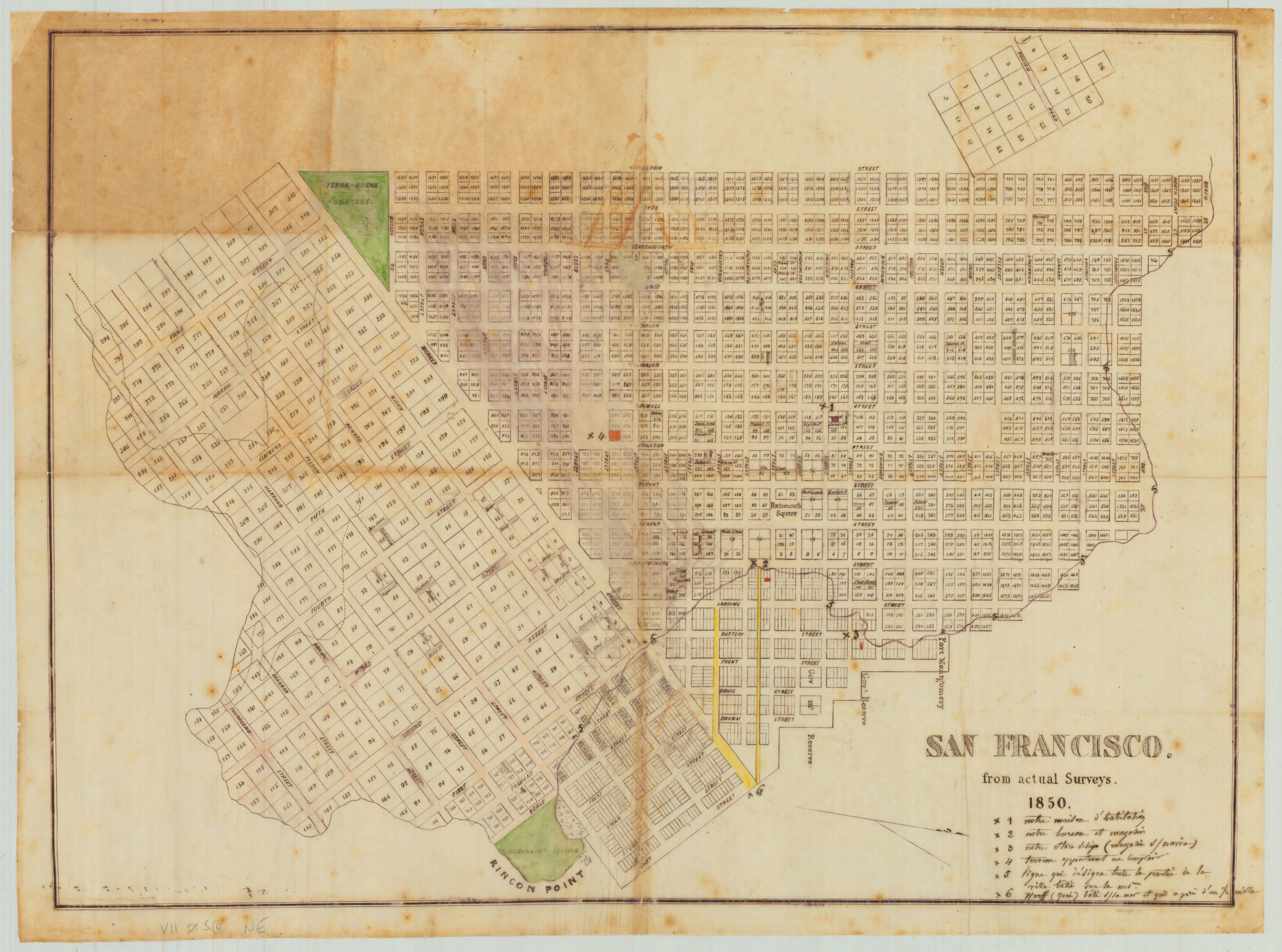
This magnificent cartographic view of Seattle prior to the great boom of the 1890s is one of the most important early renditions of the city ever made. The accomplished American cartographer William H. Whitney issued the map as a sizable (25 by 34 inches) hand-colored lithograph. The difference between the city depicted by Whitney and the Seattle we know today makes this map especially compelling.
Whitney’s plan shows the Emerald City shortly after Washington achieved statehood and was formally absorbed into the Union in 1889. The recent incorporation of Washington state naturally caused a spike in interest in the rest of the country, and the map was a direct response to this demand. In fact, this map pairs beautifully with another Whitney map from the same year, which depicts the eastern hub of Washington state: Spokane Falls. Both maps were issued in 1890 but copyrighted the year before in anticipation of the national interest generated by statehood.
The Seattle map was compiled and issued as an advertising venture by real estate broker John A. Milroy and the Union Pacific Railroad. We find all sorts of unexpected and historically interesting information incorporated onto this map. In addition to standard features of infrastructure such as street grids, railroads, wharves, and docks, we also find specific details such as a breakdown of plot ownership and direct references to who those owners might be. The map shows a large urban zone where much land remains undeveloped. In many ways, Seattle appears fractional and disconnected, a situation that would change rapidly in the years following our map’s publication.
While the map focuses on the city itself, it also includes two insets, the purpose of which is to show Seattle’s geographic context and how it connects to the rest of the region. On the right side of the map, we find an inset of Puget Sound, which incorporates sailing and ferry routes between Seattle and the neighboring towns on the sound. To the left, the perspective has zoomed out somewhat, allowing the regional transportation infrastructure around Seattle to take pride of place. Together, the insets provide a general insight into the state’s system of roads, rails, and sailing routes.
Sources and the publisher
Most historians agree that W.H. Whitney is civil engineer William Henry Whitney, who established his own surveying and mapmaking firm in Boston in 1888. Between 1889 and 1890, Whitney collated the work of countless civil, military, and railroad engineering surveys and then cross-referenced these with the records from local land offices to produce a series of highly accurate maps of the western cities that the Union Pacific and Northern Pacific Railroads serviced.
In addition to Seattle, his subjects included Salt Lake City, Portland, Astoria, Spokane, Port Townsend, Tacoma, and Bellingham Bay. All of these maps bear the distinctive logo of the Union Pacific, indicating that the railroad at least partially financed their production. Often, local secondary partners – in our case, real estate broker John A. Milroy – were explicitly listed on the maps. In addition to the sponsoring entities, Whitney’s map also bears a reference to copyrights filed in Washington, D.C.
As indicated in the title of this particular map, the configuration of Seattle at this time came from the official records of one O.P. Anderson. This association anchored Whitney’s map in official records and thus gave it credence. Oliver Phelps Anderson was one of the first map publishing companies in Seattle. Its founder had several careers behind him, working as an accountant, a photographer, a photographic supplies merchant, and a draughtsman in the late 19th and early 20th century. The first maps we know from Anderson’s hand date back to the 1880s. Most of these were issued in a blueprint format, a cheap and quick form of printing that allowed for the easy incorporation of new information. Anderson’s first known blueprint city plan was a joint venture that in 1885 mapped out western Seattle in five-acre tracts using the records from Kings County. Five years later, this would serve as the basis for Whitney’s more ambitious plan, including the innovative use of color coding to show land ownership and urban development trajectories.
Ultimately, Whitney’s maps represent some of the earliest plans of the new urban spaces being created in the Pacific Northwest and are consequently considered a crucial body of records for the growth of cities in this region.
Census
As noted above, Whitney’s maps constitute some of the earliest maps of cities in the Pacific Northwest, making them both rare on the open market and highly sought after by both institutions and private collectors. Dedicated maps of Seattle that predate 1890 are scarce on the market.
The OCLC lists examples of this particular map at the Universities of Yale, Harvard, Berkeley, and Washington, just as the New York Public Library holds a copy (no. 79421183). Separate listings for this map also place copies at Stanford (nos. 953572123/953568177).
Cartographer(s):
Oliver Phelps Anderson was one of the first map publishing companies in Seattle.
William Henry WhitneyWilliam Henry Whitney (January 3, 1843 – May 4, 1909) was an American civil engineer active in Boston in the second half of the 19th century. Whitney is known for his pioneering maps and plans of cities in the Pacific Northwest.
Whitney was born in Massachusetts and studied at Harvard University. In 1862, he enlisted in the Union Army to partake in the Civil War (1861 – 1865), where he was wounded at least twice. After his return to Cambridge, Whitney served as Alderman and was involved with producing several maps and plans as part of the Boston City Engineer’s Office. In 1872 he partnered with J. Franklin Fuller to create an engineering firm. In this role, Whitney was an influential American proponent for the use of blueprint technology in both architecture and engineering.
When Fuller retired in 1888, Whitney took complete control of the company, which now bore his name. The following year, Whitney won a decisive contract with Union Pacific, which commissioned him to produce a series of plans for the new north-western cities, including Portland, Seattle, Astoria, Spokane, and others.
Condition Description
Very good. Professionally restored and re-backed. Crimped at one corner.
References
Related products
-
-
Add to cart
- San Francisco
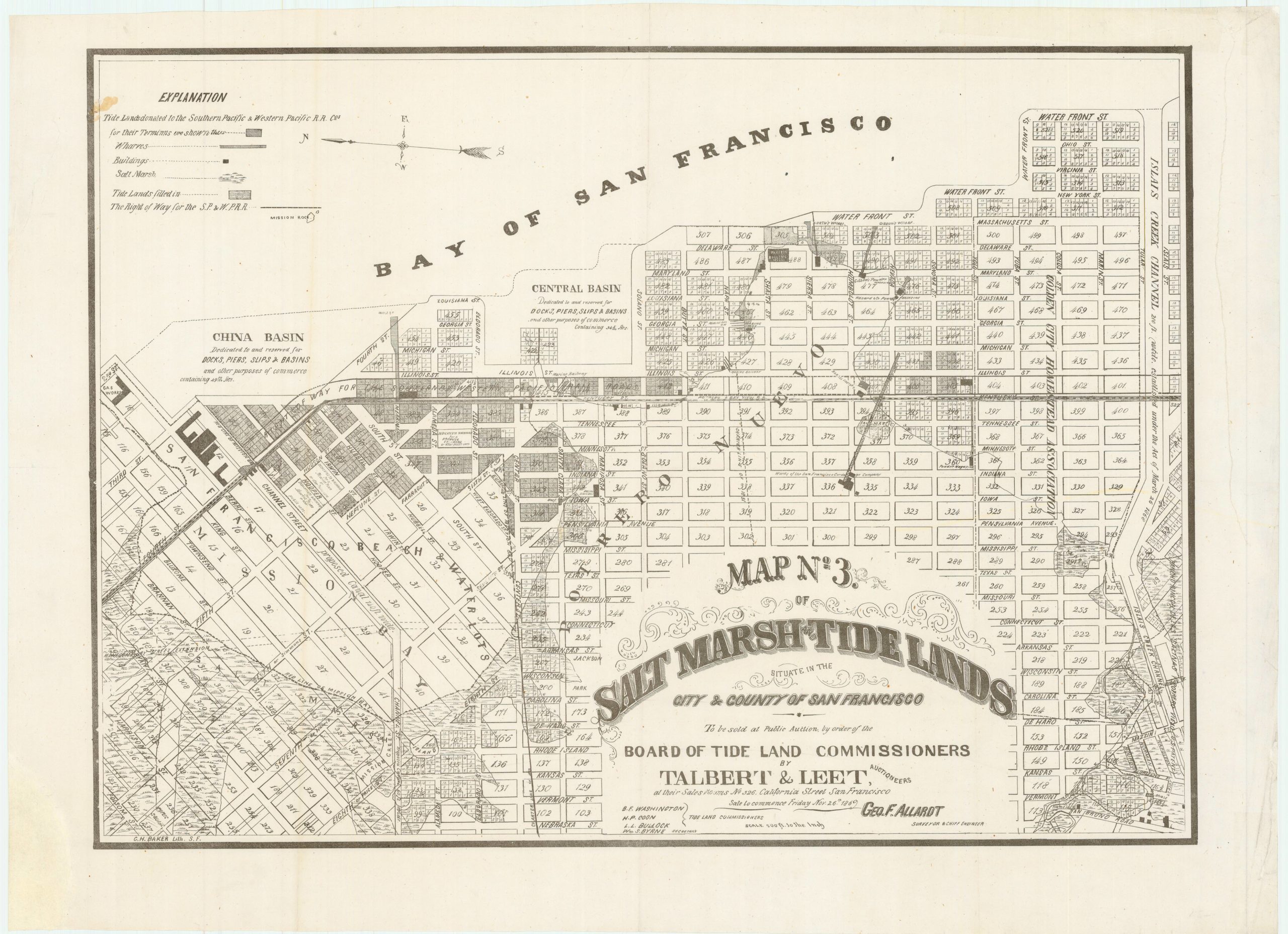
Map no. 3. Salt marsh and tide lands situate in the city and county of San Francisco. To be sold at public auction by order of the Board of Tide Land Commissioners by Talbert & Leet, auctioneers, at their sales rooms no. 526 California Street, San Francisco. Sale to commence Friday Nov. 26th, 1869.
- $3,400
-
-
-