A rare milestone in the early mapping of Polar Regions.
Deliniatio Cartae Trium Navigationum per Batavos, ad Septentrionalem Plagam, Norvegiae, Moscoviae, et Novae Semblae…
Out of stock
Description
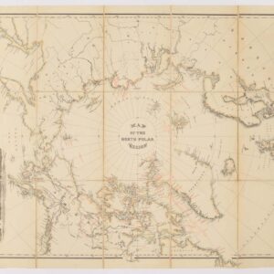
Willem Barentsz, renowned as a leading figure in early Arctic exploration, contributed significantly to cartography with his meticulously crafted map of the Polar Regions, published in Amsterdam in 1598. The map was compiled following his third voyage (1596-1597) and was skillfully engraved by Baptista van Doetecum. It is a hallmark of Arctic cartography today, as when it was first published.
Polar Coasts and Novaya Zemlya
Even though the map is in the fantastical and figurative style of the late Renaissance, Barentsz’s map demonstrates a deep personal understanding of the region he depicted. Barentsz had, after all, captained multiple expeditions along Scandinavia and Russia’s Arctic coastlines. Of particular importance is the eastern extent up to Novaya Zemlya, where he and his team were the first Europeans to venture. The west coast of Novaya Zemlya is even more detailed, including many local place names. The map also identifies where Barentsz and his crew established their winter refuge, known as ‘Het Behouden Huys.‘
Spitsbergen and Speculative Asian Coasts
Distinguished as the first map to illustrate Spitsbergen, Barentsz’s exploration in 1596 led to the discovery of this northern archipelago. The map also features speculative coastlines of Asia, depicting unfinished shores in Tartary. It intriguingly portrays the mythical Strait of Anian and the enigmatic Polus Magnetis (Magnetic North Pole), demonstrating his keen awareness of the effects of magnetic declination.
The Legacy of Willem Barentsz
A prominent pioneer of Arctic exploration, Willem Barentsz’s voyages helped shape Dutch aspirations for finding new trade routes to Asia. Despite facing harsh Arctic conditions and enduring several perilous journeys, Barentsz’s expeditions laid the foundation for all subsequent Arctic exploration. His meticulous observations and cartographic endeavors significantly advanced the understanding of the Polar Regions, leaving an indelible mark on the annals of exploration and mapmaking.
Census and Rarity
This map was originally published as a separately issued map, but many surviving examples can be found bound into composite atlases of the period. The map was also included in some copies of Linschoten’s Navigatio ac itinerarium… (Amsterdam, 1598). Linschoten commissioned Baptist van Deutecum, one of the finest engravers and artists in the Low Countries, to design and engrave the map.
While Barentz’s attempts to find the Northeast Passage were ultimately not successful, his bravery and intellectual curiosity inspired future generations of polar explorers. This map is the foundation for all future Arctic mapping, making it one of the most significant maps of its period.
Cartographer(s):
Condition Description
Beautiful impression. Cut to the neatline on the left and re-margined. A few other minor fold splits, repaired on verso and two minor spots.
References
Ginsberg, W.B. (Scandinavia) #47, fig. 47.0; TMC 9, p.10.
![[Arctic Exploration] Nord Polar Karte von V. v. Haardt.](https://neatlinemaps.com/wp-content/uploads/2024/05/NL-02108_thumbnail-300x300.jpg)