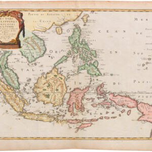
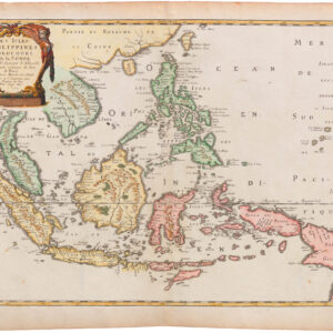
Wonderful 1635 map of Asia with cities and figures.
Asia noviter delineata
Out of stock
Description
A wonderful example of Willem Blaeu’s famous map of Asia, a cornerstone map for any collection.
One of the most notable 17th century maps of the continent of Asia, with a splendid carte-à-figures border and rich ornamentation of animals, sea monsters, and sailing ships.
The eastern coastline of Asia is severely truncated, Korea is shown as an island, and Japan is depicted on the Ortelius-Teixeira model. The Indian subcontinent is quite narrow and the islands of Indonesia are very sketchy.
The frieze across the top features vignettes of the cities of Candy, Calecut, Goa, Damascus, Jerusalem, Hormuz, Banten, Aden and Macao. The side panels flanking the map depict costumed figures of the various peoples of Asia.
Cartographer(s):
Willem Janszoon Blaeu (1571-1638) was one of the most important Dutch geographers and mapmakers of the 17th century. He was born the son of a herring merchant but traded fishmongering for studies in mathematics and astronomy. Blaeu’s first important breakthrough was winning an apprenticeship with the famous Danish astronomer Tycho Brahe. Working at Brahe’s Uranienborg observatory on the island of Hven, Blaeu learned various disciplines and technical skills. These included mathematics, astronomy, instrument-making, and more esoteric disciplines such as alchemy. Returning to his native Holland, Blaeu established a publishing business in Amsterdam. He sold instruments and globes, printed maps, and his own editions of some of the great philosophical works of contemporary intellectuals like Descartes and Hugo Grotius. Achieving notoriety as a cartographic pioneer, Blaeu was appointed Chief Hydrographer to the powerful Dutch East India Company, a position he held until he died in 1638.
When Willem died, his sons Cornelis (1610-1648) and Joan (1596-1673) took over the business. Joan had originally trained as a lawyer but never took up the practice, preferring to work on maps with his father. After Willem’s death, Joan continued publishing his father’s and his own maps. He also assumed his father’s position as a hydrographer for the Dutch East India Company. Towards the end of his life, Joan would dramatically expand his father’s Atlas Novus (1635), turning it into his own masterpiece, the Atlas Maior (1662-72).
When Willem died, his two sons Cornelis (1610-1648) and Joan (1596-1673) took over the business. Joan had originally trained as a lawyer, but never took up practice, preferring to work on maps with his father. After Willem’s death, Joan continued to publish both his father’s and his own maps. He also assumed his father’s position as hydrographer for the Dutch East India Company. Towards the end of his life, Joan would dramatically expand his father’s Atlas Novus (1635), turning it into his own masterpiece, the Atlas Maior (1662-72).
Condition Description
Excellent. Margins expertly extended and backed with archival paper.
References
Van der Krogt 2, 8000:2; Schilder 6, 21:2.