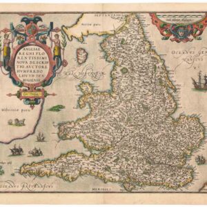
Thomson’s classic 1814 map of England and Wales.
England
Out of stock
Cartographer(s):
John Thompson
Date:
1814
Place:
Edinburgh
Dimensions:
60 x 50.5 cm (23.6 x 19.9 in)
Add to Wishlist
Add to Wishlist
Description
Attractive map of England and Wales characterized by Thomson’s high level of detail, from his New General Atlas.
John Thomson (1777-1840) was a Scottish cartographer from Edinburgh celebrated for his 1817 New General Atlas, published by himself in Edinburgh, John Cumming in Dublin, and Baldwin, Cradock & Joy in London. Thomson maps are known for their lovely color and size, representing some of the finest cartographic art of the 19th century.
Cartographer(s):
Condition Description
In good condition with several old repairs near the centerfold and margins.
References
Rumsey 1007.013. Phillips (Atlases) 731. Newberry Library: Ayer 135 T4 1817.