1680 De Wit map of the Holy Land with Jerusalem
Terra Sancta, sive Promissionis, olim Palestina Recens Delineata, et in Lucem Edita
Out of stock
Description
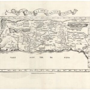
North is oriented to the right on this richly decorative map of the Holy Land. The coast is filled with many different kinds of ships, including one bringing cedar for Solomon’s Temple, and another storm-tossed ship with a sea monster that illustrates the Jonah and the whale bible story. The Kishon (Cison) River connects Haifa Bay to the Sea of Galilee.
At bottom is an inset of the encampment of the Tribes surrounding the Tabernacle, flanked by Moses and Aaron. The top of the map is decorated with an elegantly engraved cartouche and garland supported by a fleet of putti.
Cartographer(s):
Frederick de Wit (1629–1706) was a Dutch cartographer and artist who drew, printed, and sold maps from his studio in Amsterdam. He was a pioneer of Dutch Golden Age cartography, and the founder of one of the most famous map-publishing houses in Amsterdam. He was born in Gouda but moved to Amsterdam at the end of the Thirty-Years-War (1618-48), which had engulfed most of Europe and ultimately liberated the Netherlands from centuries of Spanish dominion.
Soon after arriving in Amsterdam, probably in 1654, De Wit opened a printing shop named The Three Crabs (De Drie Crabben). A year or two before, he had married Maria van der Way, the daughter of a wealthy Catholic merchant, and this may have helped secure the funding to start his new operation. His aspirations as a cartographer were nevertheless made clear when he shortly after changed the name to The White Chart (Het Witte Pascaert), under which he gained international renown.
In the latter half of the century, De Wit began drawing, copying, and publishing atlases and maps. By the 1670s he was issuing large folios with up to a hundred maps in each tome, including a famous nautical atlas in 1675. From 1689, De Wit received a state privilege from the Dutch government to draw and issue maps. This protected his work from the illegal copying known from his earlier charts. De Wit was among the first to apply extensive coloring and his original color atlases and continental charts remain highly sought after to this day.
Following De Wit’s death in 1706, his wife ran the business for four years before selling it at auction in 1710. Their only surviving son was a successful merchant in his own right and had no interest in taking over. At the 1710 auction, most of De Wit’s plates were sold to Pieter Mortier, another Amsterdam cartographer and engraver. After passing the firm to his son, who teamed up with Johannes Covens, the firm became Covens & Mortier, the largest cartographic publisher of the eighteenth century.
Condition Description
A dark impression with a few tiny spots and short centerfold separations in top and bottom blank margins.
References
Laor #860.