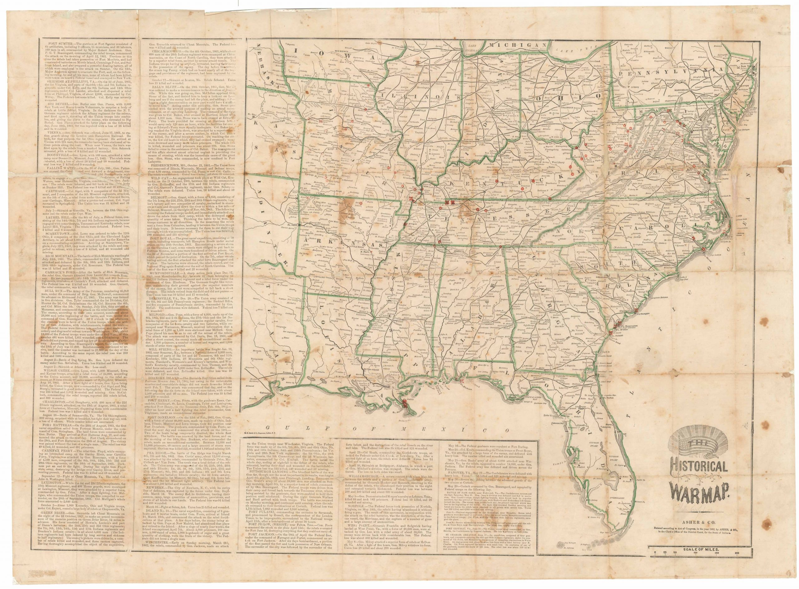
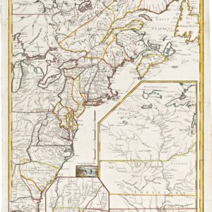
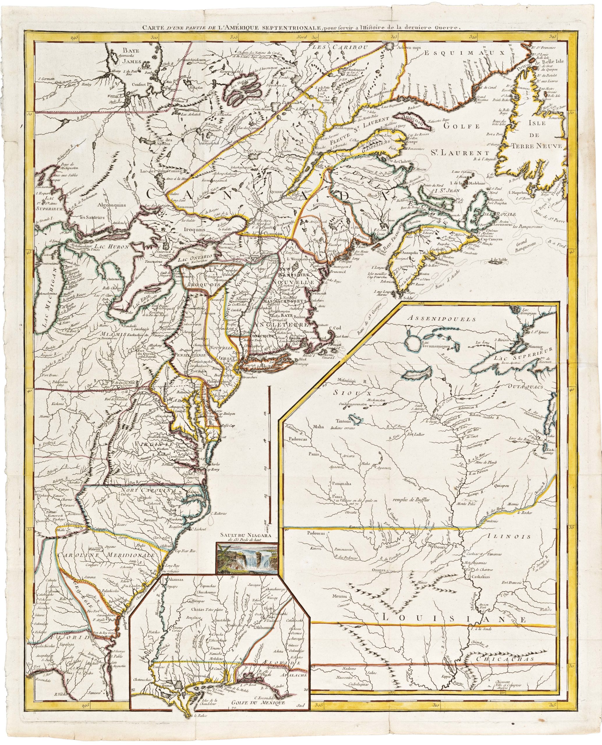
Samuel Lewis’ extremely rare patriotic map of the War of 1812.
A Correct Map of the United States, With The West Indies, from the best Authorities by Samuel Lewis 1813…
Out of stock
Description
This stunning wall map, published in 1813 by Philadelphia-based cartographer Samuel Lewis, captures a neonate American Republic, only a few generations after independence from Britain. It is particularly important due to its treatment of Florida. Of the three American maps produced during the War of 1812 — the other two being the 1812 Bradley map and the 1816 Shelton & Kensett — the Lewis map is the only one to include the full Florida peninsula.
Florida had been a British stronghold during the Revolutionary War, but following a Spanish invasion in 1781, Britain ceded Florida to Spain. In 1810, three years before this map was published, a group of English-speaking settlers declared West Florida independent of the Spanish Crown. Almost immediately thereafter, West Florida was annexed by the United States. The inhabitants of West Florida had set up a provisional government, but this was not acknowledged by Congress. In 1812, President James Madison signed off on a secret plan to continue their westward expansion, aiming to take the panhandle all the way to the Perdido River.
The United States purchased Eastern Florida from Spain in 1819, uniting it into a single territory in 1822. In 1813, however, none of this was yet a reality. Nevertheless, Lewis compiles a map in which Florida is looking distinctly American. Western Florida remains unlabeled as if to signify that the conflict and even the division itself were non-existent. Moreover, Lewis opts for a coloration scheme in which Florida is undivided and undistinguished from the other American states in any way. In fact, without a solid grasp of the chronology, one could easily be led to believe that Florida already was part of the United States at this stage.
This representation was entirely deliberate and reflected a widely-held notion in America that expansion had to be sustained by the contraction of European presence. Thus, while the United States engaged in conflict with the British Empire at its northwestern frontiers, this patriotic map-maker from Philadelphia did not neglect an opportunity for the Republic to expand in other directions as well.
As the United States had no legitimate claim on Florida, the Lewis map treats us to one of the most blatantly imperialistic cartographic visions in American history. Like his counterparts at the time, Lewis focuses on the frontiers in America’s war with the British. However, as mentioned above, his map was the only American map of the era to include the full scope of both the Florida panhandle and peninsula. Abraham Bradley’s postal map from 1812 did include some of the annexed areas in the panhandle but was peripheral in the greater scope of things. Something similar could be said about the Shelton & Kensett map of 1816, in which Florida has been more or less omitted. The fascinating configuration of the Lewis map reveals the mapmaker’s opinion as to Florida’s ‘natural affiliation,’ and showcases his belief in a great American Empire.
Census
Neatline’s copy is the Second Edition (Containing the Seat of War &C), as noted along the top of the map. At the bottom, we find the publication information, which informs us that the map was published by T.L. Plowman in Philadelphia in 1813, and subsequently “Entered according to act of Congress 22nd Mar.”
We have found no other examples of the 1813 edition in historical sales records over the last 50 years. The Osher Map Library has this 1813 edition, David Rumsey has an 1817 (3rd) edition which appears to be cartographically identical (the title cartouche has nevertheless been moved towards the east coastline), and the Library of Congress has an 1820 edition. The American Philosophical Society references an 1811 issue, which presumably is the first edition.
Cartographer(s):
Samuel Lewis (c. 1754-1822) was an engraver and cartographer who emigrated from Dublin to North America. Here he settled in Philadelphia and partnered up with two of the city’s most important publishers: Matthew Carey and Henry Schenk Tanner. Lewis worked as a geographer, draftsman, and mapmaker, and made substantial contributions to Mathew Carey’s seminal American Atlas (1797).
Later, Samuel Lewis would also collaborate with London mapmaker Aaron Arrowsmith on several important works, including an American edition of Arrowsmith’s impressive world map. For the Arrowsmith map, as well as his War of 1812 masterpiece, Lewis used the well-known Philadelphia publisher T.L. Plowman.
Samuel Lewis should not be confused with the London publisher Samuel Lewis the Elder (1782-186) who was behind several topographical works on Great Britain and Ireland.
Condition Description
Gorgeous. Repairs to margins, mounted on new linen. Old color, partially refreshed.
References
Rumsey #3324; cf. Phillips (M) p. 880; cf. Ristow p. 266.