Cassini’s multi-sheet map of Colonial North America in original black and white
Gli Stati Uniti dell’America Delineati sulle ultime Osservazioni…
Out of stock
Description
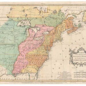
Full set of Cassini’s uncommon six-sheet map of the United States. Each map includes excellent detail, including early roads, Native American details, and early settlements. Can be joined together to make one large, striking map, or kept separate. The Sesto Foglio in the lower right includes an interesting inset of Newfoundland.
Cartographer(s):
Giovanni Maria Cassini (1745 – 1824), a disciple of Giovanni Battista Piranesi, was a geographer, cartographer, and engraver working in Rome for decades between the late 18th and early 19th centuries. He invented a new method of projection, called Cassini, famously used for the geographical atlas of the kingdom of Naples in 32 sheets signed by Giovanni Antonio Rizzi Zannoni.
Condition Description
Excellent impression with ample margins. Spotted soiling and minor discoloration on the centerfolds; various surface blemishes.
References