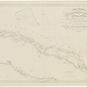
De l’Isle’s seminal rendition of Canada in the desirable Post-Revolution state!
Carte du Canada qui comprend la partie septentrionale des Etats Unis d’Amérique.
Out of stock
Description
De l’Isle’s important depiction of French interests in Canada as they related to the newly formed United States, including new information on the Rocky Mountains and other discoveries in the West.
This exceptional and scarce state of Guillaume De L’Isle’s seminal map of western Canada showcases not only French interests in the region but new insights into the Great Lakes and the Upper Midwest regions, as well as some of the first tantalizing indications of the Rocky Mountains somewhere out west. As with most maps, it is a deeply political document, but the map is also of great historical significance as it denotes the border region with the newly formed United States of America. In fact, it is the first formal state of this map in which the Etats Unis (United States) are mentioned in the title. It is a masterpiece of French cartography and one of the most significant and influential maps of the region to be created in the late 18th Century.
Neatline’s example of this map is considered the second Dezauche printing of De L’Isle’s groundbreaking map and is, as mentioned, the first state to include the name of the United States in the title. Moreover, it is one of the earliest instances of the words Etats Unis appearing on a printed map. It is worth noting, however, that there are two different editions of the 1783-Etats Unis map, with the second and later editions featuring modifications made by Dezauche following the French Revolution in 1789. These changes include the removal of the crown and the royal fleur d’lis from the cartouche, as well as the reference to the king in the title. This change was no doubt made to accommodate a heated and dangerous political climate, although the mapmaker’s own royal privilege – avec privilege du Roy at the bottom of the cartouche – was maintained.
In addition to its unique political and historical background, the map is of considerable cartographic significance for various regions in North America – in particular, the Great Lakes and the Rocky Mountains. De L’Isle had studied the work of Jesuit Missionaries like Franquelin and Jolliet during his time at the French Maritime Ministry (1700-03), and his meticulous research is evident in the detailed and accurate depiction of the Great Lakes. The map not only positions the lakes correctly relative to Hudson’s Bay but also provides a far more realistic portrayal of the Avalon Peninsula compared to earlier maps. De L’Isle demonstrates the same remarkable level of accuracy in depicting the geography of the James and Hudson Bay littorals, which included the elaborate river systems that fed into them. And last but not least, the map includes early evidence for the sources of the Mississippi River.
Another notable feature of this map is its inclusion of one of the earliest references to the Rocky Mountains (referred to here as the Riviere Longue), based on Baron de Lahontan’s accounts. Lahontan was a member of the French Marine Corps sent to New France in 1683, where he explored the Wisconsin, Minnesota, and upper Mississippi Valley regions extensively. He learned several indigenous languages and became skilled in wilderness survival. Lahontan’s explorations took him to Fort St. Joseph near present-day Port Huron, where he commanded the fort for a time. He also ventured into the upper Mississippi Valley, allegedly discovering the Riviere Longue referred to on De l’Isle’s map. Lahontan’s travels included various adventures, such as a successful attack on English frigates in the Gulf of St. Lawrence, before he eventually deserted the French military and returned to Europe. His popular account, Nouveaux voyages dans l’Amérique septentrionale (1703), recounted his travels and retold indigenous reports to substantiate the idea of a great river flowing into high mountains, beyond which lay a vast body of salt water. Lahontan’s accounts were so convincing that many scholars and intellectuals in France accepted the notion of such a waterway, which in turn led major mapmakers to incorporate it as a feature on their maps.
While Des l’Isle is not about excluding Lahontan’s river and mountains, he reveals his skepticism by including a note regarding these features: “…unless the Seigneur de Lahonton has invented all of these things, which is difficult to resolve, he being the only one who has penetrated this vast land.” While Lahontan’s Long River may have proved a fantasy, the reference to the Rocky Mountains by De L’Isle is believed to be the first serious depiction of this enormous range on a printed map. Beyond the mountains, De l’Isle, like Lahontan, alludes to a large body of salt water to the west. This could be an early reference to the Great Salt Lake or even a tantalizing hint of the Pacific.
Overall, De L’Isle’s map of Canada and the Great Lakes stands as a seminal cartographic achievement, accurately portraying the region and featuring early references to the Rocky Mountains. Moreover, the second Dezauche state of the map includes one of the first explicit references to the United States in a printed map, while the later edition of this second state also reflects the French Revolution, the dissolution of the monarchy, and the creation of the first Republic. It is an important and highly collectible historical document. Neatline’s example of this iconic map is made even more attractive by the elegant highlighting of borders in various colors.
Census
The OCLC lists a number of institutional holdings, including the Bibliotheque nationale de France (no. 494209931), Universitätsbibliothek Bern (no. 956307091), Bayerische Staatsbibliothek (no.165878258), and the Library of Congress (no. 5408225).
Cartographer(s):
Guillaume de l’Isle (1675-1726) was a French cartographer who was a key figure in the transition toward a more scientifically grounded cartography.
He was renowned for the extraordinary quality and accuracy of his maps. Especially his depictions of North America stand as some of the most critical milestones in mapping the continent, as they were based on the most up-to-date information available and were free of all mythical or imagined embellishments. De L’Isle also recalculated latitude and longitude based on the most recent celestial observations and incorporated these revisions onto his maps. In doing so, he set new, entirely different standards for cartographic accuracy.
De l’Isle came from a family of French cartographers, though none were as acclaimed as he would become. He trained under his father from an early age and later studied mathematics and astronomy under Cassini. This combination of practical mapmaking experience and a deep scientific understanding of cartographic principles allowed De l’Isle to become one of the most significant figures in early 18th-century cartography.
De l’Isle established his firm in his twenties, issuing his first atlas in 1700. Two years later, he became a member of the Royal Academy and moved his firm to the Quai de Horloge, a center for printing and mapmaking in Paris. In the following years, Guillaume De L’Isle would produce some of his repertoire’s most iconic and essential maps. In 1718, he was appointed Royal Geographer to King Louis XIV, a position which he maintained under Louis XV until his premature death in 1726.
Philippe BuachePhilippe Buache (born La Neuville-au-Pont, 7 February 1700; died Paris, 24 January 1773) was a French geographer, known for inventing a new system of geography and popularizing this field.
Buache was trained under the geographer Guillaume Delisle, whose daughter he married, and whom he succeeded in the Académie des sciences in 1730.
Buache was nominated first geographer of the king in 1729. He established the division of the world by seas and river systems. He believed in a southern continent, an hypothesis which was confirmed by later discoveries. In 1754, he published an “Atlas physique.”
The Dezauche FamilyJean-Claude Dezauche was a well-known Paris map publisher who set up his shop around 1770. The foundation for the business was his acquisition of the archives of Guillaume De l’Isle and Philipe Buache, two of the most highly-renowned royal French cartographers.
Among Dezauche’s many lucrative contracts was a monopoly on selling the maps produced by the national Dèpôt de la Marine. When his son, Jean André Dezauche, took over the family business upon his father’s death, he inherited this contract.
Condition Description
Some repairs visible on verso, discoloration and other minor blemishes not affecting image.
References