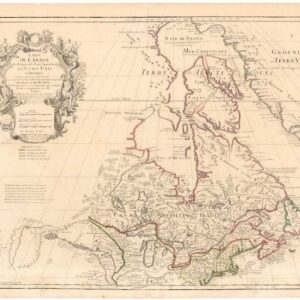
One of the few Great Lakes maps published at the brink of the American Revolution.
Partie Occidentale Du Canada et Septentrionale De La Louisiane Avec Une Partie De La Pensilvanie Par Le Sr. D’Anville…1775
$550
In stock
Description
This compelling map, showcasing the Great Lakes and Upper Mississippi region, was published just before the onset of conflict between England and the American Colonies. It spans from Lake Ontario in the east to James Bay in the north and stretches southeastward to Philadelphia. With its foundation rooted in D’Anville’s map of North America, it highlights several French forts and is rich in details about Native American tribes and settlements. The Missouri River Valley extends to Kansez and Ft. d’Orleans, with even the early naming of Chicagon evident on it.
The map offers intricate depictions of the lower Missouri and upper reaches of the Mississippi. It identifies the Keweenaw peninsula as Kiaonan and refers to Isle Royale as I. Minong, plotting numerous Native American tribes and their respective villages.
Map expert R.V. Tooley commented on D’Anville’s map, underscoring its significance in 18th-century cartography. He emphasized D’Anville’s dominance over his contemporaries, praising his approach of leaving uncharted areas blank where knowledge was lacking. D’Anville’s portrayal of the Great Lakes was notably superior to that of his peer, John Mitchell.
Cartographer(s):
Jean Baptiste Bourguignon d’Anville (born in Paris July 11, 1697 – January 28, 1782) was a geographer and cartographer who greatly improved the standards of map-making. His maps of ancient geography, characterized by careful, accurate work and based largely on original research, are especially valuable. He left unknown areas of continents blank and noted doubtful information as such; compared to the lavish maps of his predecessors, his maps looked empty.
Paolo SantiniPaolo Santini (1729-1793), an esteemed cartographer from Venice, was actively producing maps during the mid to late 18th century. He gained acclaim for his “Atlas Universel,” a comprehensive collection showcasing all known regions of the world. Each map within the atlas stood out for its intricate engraving, seamlessly melding artistic elegance with up-to-date geographical data. Often, Santini would adapt and refine the works of his contemporaries, a prevalent practice of the era, ensuring the latest knowledge was readily available to his audience.
Condition Description
Original outline color. Good condition, discoloration along centerfold and former dampstaining marks.
References
![[Vietnamese Maps of North America: Mexico, Canada, USA]](https://neatlinemaps.com/wp-content/uploads/2022/04/NL-01262-USA_thumbnail-scaled-300x300.jpg)