The first complete geological profile of Saudi Arabia and her neighbors; the result of a collaboration between ARAMCO and the U.S. Geological Survey.
Geologic Map of the Arabian Peninsula.
Out of stock
Description
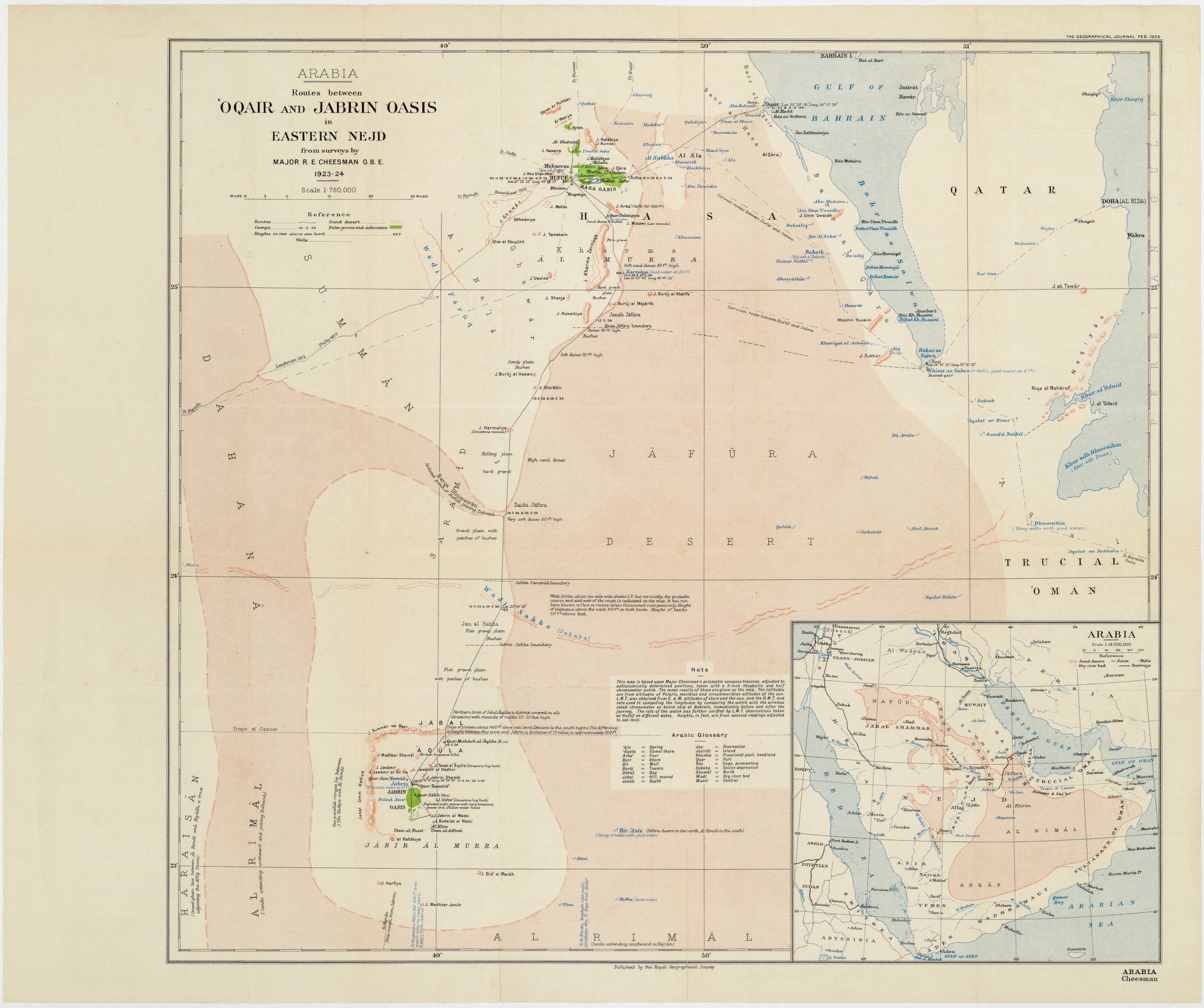
This monumental wall map of the Arabian Peninsula, issued in 1963, was the result of a remarkable collaboration. The U.S. Geological Survey and the Arab-American Oil Company (Aramco) joined forces, sponsored by Saudi Arabia’s Ministry of Petroleum and the U.S. Department of State. This partnership underscored the immense importance of the project, both then and now. The map’s thematic focus is on the geological makeup of Saudi Arabia and the states surrounding it (i.e., Oman, Yemen, Bahrain, United Arab Emirates, Qatar, and Kuwait). The level of detail required to visualize Arabia’s complex geological composition was immense, which is why a scale of 1:2 000 000 and Lambert’s Conformal Conic Projection was applied.
Holding the largest fossil fuel deposits on the planet, Arabia was already of considerable interest to American and British oil companies from the 1930s. When the U.S. Department of State and the Saudi Ministry of Petroleum joined forces to commission this map, it was not the first geological survey undertaken by the Americans in Saudi Arabia. It was, however, the most comprehensive, which meant that this particular map soon superseded all those that had preceded it. It is precisely the degree of accuracy and detail that has made this map so collectible.
Prior to this US-Saudi collaboration, many oil-related maps had been issued, including several by the Arabian American Oil Company. Among these important predecessors was a printed map first issued in 1951 (and revised in 1953). These maps were often printed with a note of caution that the information conveyed could be subject to continual changes and updates, reflecting that the physiographic understanding of Arabia in many places was still based on arbitrary descriptions like travelers’ accounts. However, it was only with the involvement of the U.S. Geological Survey and the publication of this map that a complete geological profile of the Peninsula was compiled. The subsequent publication of a series of geological reports and assessments based on this map is a testament to its seminal role in advancing our understanding of the region’s geology.
The map was issued as part of the Miscellaneous geological investigations series and was numbered ‘map I-270A’. It was initially printed as a single sheet measuring 130 by 186 cm (or 51 x 73 inches), and its high resolution and enormous dimensions reflect that it was created as a tool for remote prospecting and mapping out potential pockets of fossil fuel. Because of its large dimensions, this map has been professionally dissected and backed on linen, allowing for easier archiving, display, and use in the field.
The extensive color-coded legends running along either side of the map provide a detailed key to understanding the geological stratification of Arabia. These also pertain to neighboring regions such as Jordan, Oman, and Yemen. In addition to the colorful geological profiles, the map contains many place names, including cities and towns, major roads, airports, islands, mountain ranges, and many other features. Topographic profiles are provided throughout the map, including along the floors of the Red Sea, Persian Gulf, and the Arabian Sea. All the nation-states that one would expect to find have been delineated. The only omission in this regard is the border between Iraq and Kuwait, an undefined line that Saddam Hussein would use to legitimize his invasion of Kuwait three decades later.
In sum, this is an impressive, almost overwhelming chart: vibrant and highly accurate in detail, beautifully executed, and monumental in size and significance.
Cartographer(s):
The Arabian American Oil Company (1933-1990; now Saudi Aramco) is a petroleum partnership between U.S. firms and Saudi Arabia, which traces its origins to 29 May 1933, when the Saudi Arabian government granted a concession to the Standard Oil Co. of California (Chevron) in preference to a rival bid from the Iraq Petroleum Co. The concession allowed the Standard Oil Co. to explore for oil in Saudi Arabia.
U.S. Geological SurveyCreated by an act of Congress in 1879, the United States Geological Survey (USGS) is a scientific agency under the U.S. government whose purpose is to investigate, survey, and map the United States territory, including natural resources and any potential threats to the depicted habitat. The organization has evolved over time, gradually adapting to the progress of science and technology.
The USGS is the only science-based agency under the Department of the Interior, and its responsibilities fall within the disciplines of biology, geography, geology, and hydrology. The USGS is considered the best authority on domestic questions relating to these subjects, and often their maps will cover several or all of these themes in the same chart.
Condition Description
Very good. Scattered wear but nothing affecting the map image. Laid on new linen.
References
Related products
-
-
Add to cart
- California
Yosemite.
- $2,400
-
-
![[Arabian Peninsula] Tabula Sexta de Asia.](https://neatlinemaps.com/wp-content/uploads/2024/03/NL-02008-NEW_thumbnail-300x300.jpg)