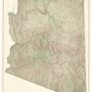
The American West during the Civil War.
Territory and Military Department of Utah.
Out of stock
Description
A comprehensive topographic map of the Territory and Military Department of Utah, covering much of the American West as it appeared during the U.S. Civil War. The map appeared in the Atlas to Accompany the Official Records of the Union and Confederate Armies, published in 1895.
Coverage ranges from southern Oregon, the Washington Territory (future Idaho), and the Nebraska Territory (future Wyoming) through Southern California and the New Mexico Territory (including future Arizona). Cities, towns, forts, wagon routes, railroads, mountains, waterways, and other features are labelled. The present map is a reprint of a somewhat larger original produced in 1860 by the U.S. Army Corps of Topographical Engineers and stored in the Library of Congress. An inset map at left displays the lands between Savannah, Georgia and Columbia, South Carolina in 1865. Savannah, the terminus of Gen. Sherman’s ‘March to the Sea,’ was captured just before Christmas, 1864; afterwards, Union armies turned northwards towards the main remaining Confederate force in Virginia.
The American West saw less fighting between Union and Confederate forces that lands east of the Mississippi River, but a pro-slavery Arizona Territory did breakaway from the New Mexico Territory join the Confederacy early in the conflict before Union armies drove the rebel forces into Texas. Fighting with Native American groups not only continued but intensified during the U.S. Civil War. The federal government also was concerned about maintaining peace with Mormons in Utah, counteracting secessionist in California and elsewhere, and safely transporting gold from California back east to help finance the war.
This sheet appeared as Plate CXX in the Atlas to Accompany the Official Records of the Union and Confederate Armies (also known as the War of the Rebellion Atlas), published by the War Department in 1895 as a companion to the Official Records of the American Civil War. Both works are exhaustive, with the atlas containing over 1,000 maps, diagrams, photographs, and illustrations.
Cartographer(s):
U.S. Government Printing Office (1861 – present) is a federal agency that was established by a Congressional joint resolution in 1860, tasked with printing and distributing information for all three branches of the federal government.
Condition Description
Some fading, minor tears.
References