An early victory in the fight to recapture the Philippines.
[SUBMARINES] Newsmap for the Armed Forces. 268th week of the war: 150th week of U.S. participation.
Out of stock
Description
A visually-stunning two-sided “Newsmap” produced by the U. S. military during the Second World War, this map provides updates on the war from multiple fronts in late October 1944 along with a detailed schematic of a U. S. Navy submarine.
On the recto, five maps display information on recent developments in the war, corresponding to adjacent text. The large map at bottom-left displays the Pacific theater, while a smaller map at top-right focuses on the island of Leyte in the Philippines, which was the site of an Allied amphibious invasion beginning on October 20. Aided by Filipino guerilla and regular fighters, along with other Allied forced, the U. S. Army troops under Gen. Douglas MacArthur were able to mostly capture the island by the end of the year, though some remnant Japanese troops continued a guerilla war for several months. The battle was a resounding success for the Allies, greatly weakening Japanese ground and naval forces and all-but-ensuring the complete liberation of the Philippines, though this unfortunately only came after a highly destructive battle for Manila the following March. A smaller map at top-left covers the central portion of Luzon, including Manila, where fighting commenced in January 1945.
A brief note mentions a Japanese offensive in China (Operation Ichi-Go), which was a rare bright spot for Japan in the last two years of the war. Japan was able to advance deep into Chinese territory and secure its own supply lines, albeit at significant cost. The operation was a disaster for China’s Nationalist (Kuomintang)-led government and its leader, Chiang Kai-Shek, and did much to contribute to his later loss in the Chinese Civil War.
Two maps at bottom right focus on Europe, with the bottom of the two depicting the Netherlands and western Germany, which saw large-scale fighting around Arnhem (recently the goal of the failed Allied Operation Market Garden) and Aachen (just captured by the Allies). The latter battle was one of the largest and most intense urban battles on the Western Front during the war, and the fall of Aachen marked the first German city on the Western Front to be captured by the Allies. Text next to the maps discusses Soviet advances in the Baltics and the Balkans, as well as Allied attempts to advance in the grinding battle up the Italian Peninsula.
The verso includes a large schematic of a U.S. Navy fleet submarine, indicating its engine rooms, crew quarters, torpedo room, control room, and more. By this point in the war, the U.S. had achieved near-complete naval supremacy, and U.S. Navy submarines, more than 200 of which were built during the conflict, wreaked havoc on Japanese cargo shipping, making it virtually impossible for Japan to resupply or reinforce troops. The situation was so dire for Japan that the large majority of Japanese casualties during the Battle of Leyte were from starvation or disease, rather than combat. Text at bottom from an official report extols the accomplishments of the submarine fleet, while three photos depict daily life and operations aboard a sub.
This Newsmap was produced by the U.S. Army Information Branch in October 1944. The OCLC (48039099) notes it at six locations in the United States; it is also held by the University of North Texas, the Library of Congress, and the National Library of Australia.
Cartographer(s):
Newsmap was a large, two-sided poster issued to the American military during World War II. It was designed to inform and boost the morale of the troops. It wasn’t a map in the traditional sense, though it often used maps as part of its layout. Instead, the Newsmap presented an assortment of news, photographs, maps, and graphics detailing the current state of the war and other related topics. The information was curated to provide soldiers with a broad overview of recent events both on the home front and in various theaters of war.
Produced by the Special Service Division of the U.S. War Department, the Newsmap was distributed weekly from 1942 to 1946. Each edition was tailored to the particular location and audience it was intended for, with different versions created for troops stationed domestically, abroad, and in specific theaters of operation.
The visual-heavy design of Newsmap made it easily digestible, and its format allowed it to be pinned up in barracks, hung in common areas, or spread out for group viewing. Through this medium, troops were kept informed about the broader context of the war they were fighting, reinforcing unity and purpose among the servicemen.
Condition Description
Some wear along fold lines.
References
Related products
-
-
Add to cart
- Asia, Pictorial maps
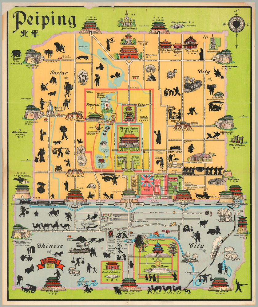
Peiping
- $1,250
-
-
-
![[Cook’s Discovery of Eastern Australia] Carte de la Nle. Galles Merid. ou de la Cote Oriental de la Nle. Hollande.](https://neatlinemaps.com/wp-content/uploads/2021/12/NL-01183_Thumbnail-300x300.jpg)
![[Cook’s Discovery of Eastern Australia] Carte de la Nle. Galles Merid. ou de la Cote Oriental de la Nle. Hollande.](https://neatlinemaps.com/wp-content/uploads/2021/12/NL-01183_Thumbnail.jpg)

![[Pair of views] Rade et Ville de Sincapour & Rade de Sincapour prise de la maison du Gouverneur](https://neatlinemaps.com/wp-content/uploads/2021/03/NL-00896-harbor_Thumbnail-300x300.jpg)
![[Pair of views] Rade et Ville de Sincapour & Rade de Sincapour prise de la maison du Gouverneur](https://neatlinemaps.com/wp-content/uploads/2021/03/NL-00896-harbor_Thumbnail.jpg)