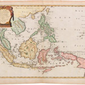
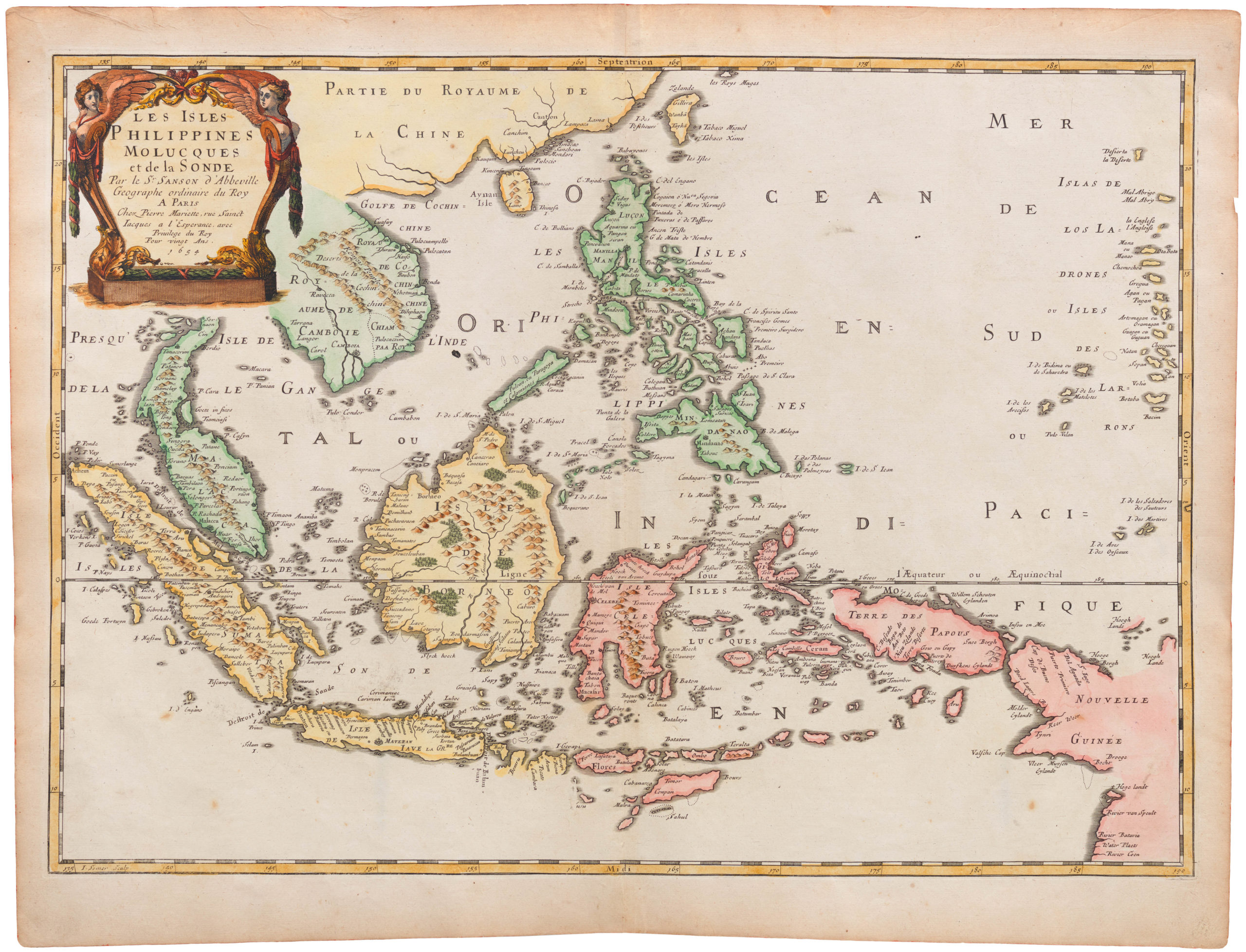
The first French edition of Cook’s chart of New South Wales — a landmark map for the cartography of Australia.
[Cook’s Discovery of Eastern Australia] Carte de la Nle. Galles Merid. ou de la Cote Oriental de la Nle. Hollande.
$1,500
1 in stock
Description
Considered in many academic circles to be among the most important charts to result from Cook’s famous search for the mythical Terra Australis, this map depicts the eastern coast of Australia. It is oriented with north to the right, and sweeps from Point Hicks and Botany Bay (Sydney), to Cape York and Endeavor Straits. The chart was published in the French language edition of John Hawkesworth’s official account of Cook’s First Voyage.
Cook’s mapping of eastern Australia was one of his primary cartographic contributions. It was achieved on his First Voyage, which set out on August 26, 1768, crossing into the Pacific via Cape Horn. While the chief mapping goal of the expedition was to expand humanity’s scientific knowledge of the cosmos, Cook’s Endeavor was also tasked with searching for Terra Australis, the vast continent believed by geographers since Antiquity to exist in the Southern Hemisphere.
After surveying Tahiti and parts of New Zealand, the expedition arrived at what is now Botany Bay in April of 1770. From here they set out to create history’s first published chart of the eastern coast of Australia. It was a remarkable achievement, with the perils of the Great Barrier Reef looming underneath at all times. The original manuscript for this map is currently held in the British Library.
For a better idea of the scope of this map, check out this georeferenced image at the David Rumsey Map Collection:
https://davidrumsey.georeferencer.com/maps/df1490cf-b0a8-5609-bd70-82d1ee2aaf4a/view
Cartographer(s):
Captain James Cook (1728-1779) was a British explorer and navigator renowned for his groundbreaking voyages during the 18th century. Born in Marton, England, Cook began his career in the Royal Navy, where he quickly distinguished himself for his navigational skills and dedication to scientific exploration. His first major voyage, aboard the HMS Endeavour, set sail in 1768 with the primary goal of observing the transit of Venus in the South Pacific. This journey led to the extensive mapping of the Pacific and the discovery of the eastern coast of Australia, which he named New South Wales. Cook’s second voyage, from 1772 to 1775, furthered his explorations of the southern hemisphere and contributed significantly to the world’s understanding of the Pacific Ocean.
Cook’s third and final voyage, which began in 1776, aimed to locate the elusive Northwest Passage and further explore the Pacific. Though he was unable to find the passage, this expedition added substantial knowledge to the geography of the South Pacific, the west coast of North America, and Alaska. Tragically, Cook’s life was cut short during this voyage when he was killed in a conflict with native Hawaiians in 1779. Despite his untimely death, Cook’s legacy endures through his invaluable contributions to understanding the world’s geography and the cultures he encountered during his expeditions, solidifying his status as one of history’s greatest explorers.
John HawkesworthJohn Hawkesworth (ca. 1715 – 1773) was a London-based editor who in 1772 was commissioned to compile and publish the journals of Captain James Cook.
Robert BenardRobert Bénard (1734 – 1785) was a French engraver and publisher from Paris.
Condition Description
Wear and surface blemishes (perhaps from use at sea?). Overall a nice example.
References
OCLC 977416224. Australia in Maps, (National Library of Australia), page 51. National Library of Australia, MAP T 325. Tooley, R.V. (Australia) 325, pl. 20. Tooley, R.V., Bricker, C.; Crone, Gerald Roe, Landmarks of Mapmaking; an Illustrated Survey of Maps and Mapmakers, p. 263. Clancy, R. 6.33. Perry, T. M., and Prescott, D. F., A Guide to Maps of Australia in Books Published 1780-1830, 1773.02.


![[Political broadside] Solidarity with the People and Students of the DPR of Korea.](https://neatlinemaps.com/wp-content/uploads/2022/10/NL-01603_thumbnail-1-300x300.jpg)
![[Political broadside] Solidarity with the People and Students of the DPR of Korea.](https://neatlinemaps.com/wp-content/uploads/2022/10/NL-01603_thumbnail-scaled.jpg)
![[Political broadside] Solidarity with the People and Students of the DPR of Korea.](https://neatlinemaps.com/wp-content/uploads/2022/10/NL-01603_thumbnail-scaled-300x300.jpg)