Mapping the emergent oil and gas industry of the American Southwest.
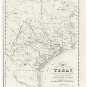
Tri-State Oil Map of Kansas, Oklahoma and Texas with portions of Old and New Mexico Showing All Oil and Gas Fields and Main Pipe Lines.
Out of stock
Description
A rare and early map of oil and gas exploration in the American Southwest. In addition to charting out the initial pipeline infrastructure in this country, it identifies operational oil gas fields in the tri-state area of Texas, Kansas, and Oklahoma (as well as in portions of New Mexico and Mexico proper).
The map provides a comprehensive overview of the fossil-fuel landscape that helped drive the technological and industrial advancement of America in the early 20th century. It is a remarkable representation of the industry’s early days, accentuating the industry and delineating the new combined oil and gas fields through distinctive red overprinting.
Even though Texas is at the center of the map, it is clear from the red overprinting that at this early stage in the industry, the highest concentrations of producing oil fields were to be found in northeast Oklahoma and southeast Kansas. This not only underscores the pivotal role these states played in the nascent fossil fuel industry of America but also helps us to date this important manifestation of that industry.
The geography of early oil in America
This comprehensive map pinpoints hundreds of well developments and the infrastructure of oil pipelines, which extend across the three main states and into adjacent regions. For Texas, we note how West Texas is decidedly less developed than the area around Dallas. This is probably due to the fact that the current map predates the discovery and massive exploitation of the Permian Basin – the largest sedimentary depression in the United States. This feature was only documented by W.H. Abrams in 1920, and the first well was not opened there until 1921. On this map, we nevertheless still find the area pristine and untouched by prospectors.
Instead, it is the fields of Oklahoma and Kansas that emerge as America’s richest oil reserves on our map. By 1915, especially following the discovery of the El Dorado field near Wichita, Kansas had become one of the country’s main oil producers. In Oklahoma, the Arkoma Basin and Cherokee Platform had been found to contain substantial oil deposits in the late 19th century, and these were already being systematically exploited at this stage. The yields from Oklahoma were so significant that during the 1920s, it competed with California to become the country’s foremost producer.
Industrial revolution and World War
In addition to representing an important part of America’s industrialization and, thus, its modernization, the emergent oil and gas industry was of crucial importance on the world stage. In Europe, the First World War was raging, and the United States was slowly but inevitably being drawn into the conflict. Oil was consequently seen as a quintessential resource, not only for economic growth at home but also for victory in Europe.
Origin and date
Our map was compiled by the esteemed F. E. Gallup Map Company, established in Kansas City in 1875. It was subsequently published by Currier & Company Oil Securities, a firm that, in addition to selling oil assets, worked with the production of trade periodicals for the oil and gas industry. The Gallup company was well known for its accurate town, county, and state maps from the American South. As was common in commercially published maps at the time, this specimen included advertisements for the Harvey Crude Oil Company (including their drilling records for the year) and the conglomerated Universal Petroleum Corporation in the lower left corner.
While this particular map is undated, we feel comfortable tentatively proposing a date around 1915. The dating is largely based on historical contextualization and comparative analyses with other oil and gas maps from the early 20th century. We already noted how our map shows the Permian Basin as unexploited, which pushes it back before the first serious prospections in 1920. Comparison with another Gallup company map from 1920 reveals other important disparities in drilling sites across both Texas and Kansas, further corroborating an earlier date for this particular map.
While the omissions help date our map, certain features that have been represented also contribute. Most notable is the inclusion of the Ebano, Panuca, and Topila fields near Tampico in eastern Mexico (at the very bottom of the map). The Panuca River complex was first developed sometime between 1910 and 1920. In 1911, the East Coast Oil Company, which was connected to the Southern Pacific Railroad, opened up some production here, which appears to be one of the productive fields indicated on our map. Soon, other companies followed suit, but problems of transport (the oil was too thick to pipe), quality, and a complex landscape of small-time producers and lease owners meant that development of the Pánuco-Topila oil fields really did not get underway until the 1920s (Brown 1993).
A final piece of contextual evidence supporting a date around 1915 is the presence of an advertisement for an edition of this map in the Indianapolis Times on January 31, 1920. If nothing else, this establishes a terminus ante quem (time before which) for the publication of this iconic map.
Census
This map is both rare and highly desirable. The OCLC lists only two institutional examples: one at the University of Kansas (no. 9126106) and another at Yale (no. 702686045).
We note a few historical sales of the map but can find no examples of this map currently being offered. Having been published for a periodical, most copies have probably been lost, making it a sound investment that will continue to appreciate in value.
Cartographer(s):
F. E. Gallup Map Company was a mapmaking company established in Kansas City in 1875 and remains one of the oldest continuously operating firms in Missouri. The company specialized in regional, state, county, and city maps of the American Southwest.
Condition Description
Very good. Minor wear along edges and some spotting. There is a small tear in the margin along the left side. Attached to the original cover, which is complete and in good condition.
The actual map looks better than our scan.
References
Brown, Jonathan C. 1993 Oil and Revolution in Mexico. University of California Press: Berkeley, Los Angeles & Oxford.