A Southern Pacific California guide and San Francisco map that we have never seen before.
Guide Map of San Francisco and Side Trips in California.
Out of stock
Description
This intriguing piece of California ephemera from the Southern Pacific Railroad is really two things at once. On one side, it is a fine late 19th-century city plan of San Francisco, showing the city at its height before the severe blow of the 1906 Earthquake. The other side offers rich detail on the history, geography, and landmarks of the state of California.
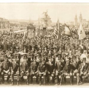
The piece is printed on nice paper and folds up to form a kind of booklet. It was published by the South Pacific Company on the occasion of the 16th International Christian Endeavor Convention. The information on the map seems aimed at helping visitors navigating the city, and the information of the verso offers travel and tourism advice.
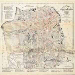
Guide Map of the City of San Francisco 1897
This fine map depicts many interesting 19th century features of the city, including Sutro Baths and Heights, the railway at today’s Land’s End, old rancho designations, waterworks, new land developments, the Lone Mountain cemeteries, and more.
Several spurious street names are shown in the Marina, including Tonguin and Lewis. These were planned to be on landfill but were never actually created; Tonguin street is instead Marina Boulevard and Lewis is Marina Green Drive.
The map has a particular focus on transportation infrastructure. In 1897, San Francisco’s streetcar system was rapidly expanding and becoming a defining feature of the city. Having started in the late 19th century with the invention and implementation of the cable car, San Francisco was at the forefront of urban transit innovation. The cable car system, developed by Andrew Smith Hallidie, began operation in 1873 and was designed specifically to handle the city’s notoriously steep hills. By 1897, several cable car lines crisscrossed the city, operated by different companies.
However, by the late 1890s, cable cars were facing competition from the electric streetcar, which was cheaper to operate and could achieve greater speeds on flatter routes. Electric streetcars began to appear in the city in the 1890s, and they quickly became popular for routes that didn’t need to tackle San Francisco’s steepest grades.
The presence of both cable cars and electric streetcars in San Francisco in 1897 showcased a city in transit transition. This period marked the beginning of the decline of the cable car’s dominance in favor of the more efficient and flexible electric streetcar, although cable cars would (and still do) remain an iconic symbol of the city and are primarily centered in the tourist-heavy areas today.
Side Trips in California
As mentioned, the verso contains a wealth of information on traveling in California, including suggested itineraries and time tables. Among the highlighted areas are Stanford University, Lake Tahoe, Yosemite, Mt. Shasta, Napa Valley, Pacific Grove, and places in Southern California.
Cartographer(s):
The Southern Pacific Railroad, often simply referred to as the Southern Pacific, was one of America’s most influential rail systems, playing a critical role in the development and growth of the Western United States. Founded in the 1860s, its primary intention was to connect San Francisco and San Diego. However, over time, it expanded its vast network, spanning from the Pacific Coast to the Midwest, covering key states such as California, Arizona, New Mexico, Texas, and Louisiana. Its routes facilitated not only the movement of goods but also the migration of people, fostering connections between communities and accelerating the economic growth of the regions it touched.
The railroad wasn’t without controversies, particularly concerning its monopolistic practices and significant political influence during the late 19th and early 20th centuries. Nonetheless, its lasting impact is undeniable, with its legacy tracks still serving as vital arteries for transportation in the modern American West.
Condition Description
Very good. Folding map printed on thick paper. Openings at two intersections.
References