An extraordinary resource for anyone interested in the geology of California.
Geological Map of the State of California Issued by State Mining Bureau…1916.
Out of stock
Description
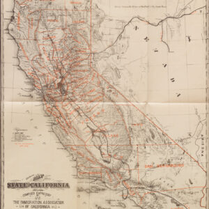
The Geological Map of the State of California is a large and meticulously detailed wall map that provides a comprehensive view of the geological features within the state of California. It was first issued by the State Mining Bureau in 1916 but was re-issued several times due to its incredible accuracy and comprehensive coverage. The map stands as one of the best examples of geological mapping at the time, serving as an invaluable resource for understanding the diverse geological landscapes of California.
The legend accompanying the map provides critical information about the geological features it illustrates, allowing users to decipher the geological composition and characteristics of various regions within California. The map is geographically oriented to the prime meridian, facilitating accurate spatial referencing. Interestingly, it does not include a relief representation, primarily focused on geological features rather than topography. Different graphic scales enable users to interpret distances in miles and kilometers, thus accommodating a broader audience.
The original map was created in 1916 under the guidance of Fletcher Hamilton, the California State Mineralogist. It features geological information meticulously compiled by James Perrin Smith. The map was continuously updated and reprinted because of its accuracy and subject matter. Neatline’s example is from 1929 – the year that kicked off the Great Depression. It was printed as a lithograph, ensuring a high level of detail and clarity in depicting geological information.
One of the prominent geological features depicted on the map is the so-called Mother Lode, represented by a distinctive thin red/orange line. The Mother Lode is a geological formation of great significance in California’s history and economy. It is a zone of gold-bearing quartz veins that runs through the Sierra Nevada foothills, spanning approximately 120 miles from Mariposa County in the south to El Dorado County in the north. This geological feature played a pivotal role in the California Gold Rush of the 19th century, attracting prospectors and settlers to the region in search of gold deposits.
In sum, the Geological Map of the State of California is an exceptional resource for anyone interested in the geological intricacies of California. Careful attention to detail provides valuable insights into the geological formations, including the renowned Mother Lode, that have shaped the state’s landscape. Whether for academic research, geological exploration, or historical reference, this map is an invaluable tool for understanding the geological heritage of the Golden State.
Cartographer(s):
The California State Mining Bureau was created in 1880 following decades of explosive demographic and economic growth in the wake of the Gold Rush. Henry G. Hanks served as the first California State Mineralogist responsible for compiling data and maps and building a collection to represent the state’s mineral resources and long mining heritage.
Fletcher HamiltonFletcher Hamilton was the California State Mineralogist during the early 20th century. He is mainly known for compiling accurate and highly detailed geological maps of California.
The Union Litho. Co.The Union Lithography Company was a commercial printing house based in San Francisco and active in the first half of the 20th century.
Condition Description
Very good for a wall map of this period, with minor blemishes and even toning.
References
![The Original Silicon Valley Map & Calendar [1994]](https://neatlinemaps.com/wp-content/uploads/2021/06/NL-00909_Thumbnail-300x300.jpg)
![The Original Silicon Valley Map & Calendar [1994]](https://neatlinemaps.com/wp-content/uploads/2021/06/NL-00909_Thumbnail.jpg)