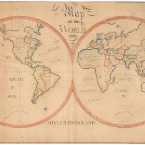
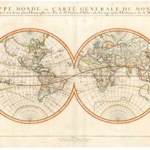
Jaillot’s famous double-hemisphere in original color and with gold highlights.
Mappe-Monde Geo-Hydrographique, ou Description Generale du Globe Terrestre et Aquatique en Deux Plans-Hemispheres ou Sont Exactement Remarquees en General Toutes Les Parties De La Terre et de L’Eau, Suivant les Relations Les Plus Nouvelles.
Out of stock
Description
This gorgeous double-hemisphere is one of the most famous and seminal world maps to be produced in the late 17th century and a cornerstone in the repertoire of French cartography from this decisive period. The map is in extraordinary condition, with magnificent and vivacious old color and highlights in gold leaf. Among the many features that reveal this as a product of the late 17th century, we find California depicted as an island and the east coast of Australia entirely unexplored.
It is a gorgeous sheet from the early stages of European cartography, which captures the world as it was understood at the dawn of the 18th century.
Complicated origins
We have characterized this map as a cornerstone in the repertoire of 17th-century French cartography. It is also an excellent example of how charts were conceived and produced during this formative stage of professional mapmaking. Like much of the best cartographic output from the 17th century, this map results from a long lineage of great maps that were copied, adapted, and expanded as geographic knowledge increased. Below, we have tried to sketch out the conceptual journey that this map has undergone before appearing in the exact configuration shown here.
Neatline’s example of this map was published by Pierre Mortier, who worked out of Amsterdam in the final years of the 17th century. Here, Mortier was competing with other renowned Dutch mapmakers, such as Gerald Valck, Pieter Schenk, and others, but he had one advantage that elevated him above his peers in many ways. Coming from Paris, Mortier was endowed with a royal privilege to sell French maps in the Netherlands. He had consequently brought the latest maps by the stellar French mapmaker Alexis-Hubert Jaillot. These maps were highly sought-after throughout Europe and would form the basis for launching his workshop in Amsterdam. He has often been accused of secretly copying Jaillot’s maps and issuing them in his name, but the fact of the matter was that this was part of a broader strategy of dissemination by the French.
By the 1690s, Alexis-Hubert Jaillot had been in business for several decades, much of it with the sons and heirs of Nicolas Sanson. Sanson is considered the father of French cartography, and his maps were, and are still, renowned as some of the finest of the age. Just as Jaillot used Sanson’s plates to build templates for his maps, Mortier and his partner Marc Huguetan reissued Jaillot’s maps in Amsterdam.
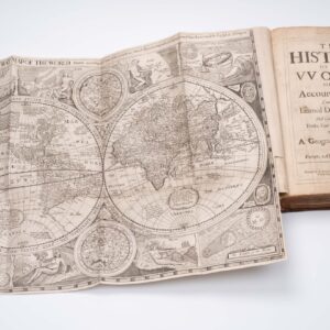
Jaillot’s essential work at this time was the updated edition of his Atlas Nouveau (1691), and Mortier drew heavily from this work while producing his own Atlas Nouveau, which hit the streets in 1696. The world map included in Jaillot’s 1691 atlas was a revision of a crucial double hemisphere chart that Jaillot first issued as a separate sheet in the 1670s and later figured in the first edition of his Atlas Nouveau from 1681. The original double-hemisphere map (Shirley 462) drew heavily on Sanson and was re-carved multiple times before being replaced. The implemented changes were nevertheless so subtle that distinguishing the states remains extremely difficult. The fourth and final plate of the original Jaillot map (Shirley 462) constitutes the same printing and state as the first edition of the revised world map for Jaillot’s new Atlas Nouveau from 1691 (Shirley 550).
Shirley notes several dated and undated states for both maps, but he underscores that undated versions of Plate IV (i.e. Shirley 550) were only issued after the dated 1696 state. Our example is undated, so we know it belongs to this late printing. Mireille Pastoureau, the great authority on French atlases, records no other editions of Jaillot’s atlas being issued in Paris after 1691, which allows us to attribute this particular state to the workshop of Pierre Mortier in Amsterdam.
Nevertheless, Mortier issued his edition of Jaillot’s Atlas Nouveau in 1696 (Shirley 581), in which he makes a number of noticeable changes that are not present in our example of this map. This allows us to attribute our specific sheet to Mortier’s workshop and to date it either to, or very close to, 1696.
Context is Everything
Pierre Mortier is well-known for replicating maps from Jaillot and other French cartographers as the basis of his business in the Netherlands. Still, it is unclear to what degree Jaillot was involved in this commercial venture.
While some people present Mortier’s very direct emulations of Jaillot’s work as a form of plagiarism, others believe that Mortier and Jaillot were working together and that Jaillot specifically provided Mortier with his latest maps for them to be copied and sold in Amsterdam. Reproducing earlier maps and reissuing them with only minute changes was a common and accepted practice. Mortier’s approach was quite extreme in his emulation, in that he copied almost every detail of Jaillot’s plate – including Jaillot’s name and Paris address, as can be seen in our example – but this is likely an indication that it happened with Jaillot’s consent.
The importance of Mortier’s shift from Paris to Amsterdam and his seemingly shameless copying of Jaillot’s maps is of considerable import for the development of cartography over the next century. In the late 17th century, French maps differed from their Dutch counterparts. They were less concerned with a map’s overall aesthetic and completeness and more interested in showing the latest developments and insights.
Beginning with Sanson, French mapmakers were more interested in pushing cartography’s boundaries and chaining its nature to an observation-based craft. By bringing this new French approach into direct competition with the established traditions of Dutch cartography, Mortier became a disruptor. But what was initially perceived as a disturbance would soon help push the discipline forward.
Cartographer(s):
Alexis-Hubert Jaillot (1632 -November 3, 1712) was a French Paris geographer, cartographer, and publisher. He was active from the last quarter of the 17th century and into the beginning of the 18th century, working closely with the sons and heirs of Nicolas Sanson and serving King Louis XIV as a royal cartographer for many years.
Pierre Mortier the ElderPierre Mortier the Elder (1661-1711) was a French cartographer and publisher who, in 1690, obtained the French king’s privilege to distribute the works of French geographers – particularly Hubert Jaillot – in the Netherlands. He subsequently settled in Amsterdam and built an extensive business on reissuing French maps. His son would take over his father’s business and become the latter half of the mapmaking duo Covens & Mortier.
Condition Description
Original color heightened in gold. Minor blemishes.
References
![[World] Continentem Dudum Notam Componebat & Continentem Noviter Detectam Componebat.](https://neatlinemaps.com/wp-content/uploads/2024/04/NL-01969-composite_thumbnail-300x300.jpg)