South Asia by France’s Royal Geographer.
Carte Générale des Indes en-deca et au-dela du Gange.
$450
In stock
Description
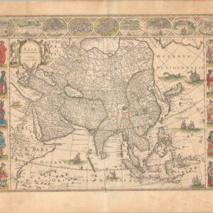
This detailed map of Greater Southeast Asia was compiled by Royal Geographer Adrien Hubert Brué in 1826 as a revision to an earlier map from 1821. It covers Baluchistan to Malaysia and Vietnam, including the Indian Peninsula.
The map has been hand-colored to outline the domains of four European colonial powers: France, Portugal, Denmark, and England. Also delineated are indigenous polities, including the Indian states of Mysore and Sikkim and the Trinh kingdom of Tonkin, which the French only subjugated in 1884.
As is consistent in Brué’s cartography, the map is highly detailed, showing all major cities, rivers, and routes, in addition to the noted geographical subdivisions. A legend in the lower left corner includes a list of indigenous polities. The map’s title is in a distinct scroll style consistent with the rest of the maps from its atlas of origin. The title identifies Brué as the cartographer and Charles Piquet of Paris as the printer/distributor. An elegant border surrounds the entire map.
Context is Everything
Adrien-Hubert Brué was a Royal Geographer during the so-called July Monarchy (1830-1848), during which Louis Philippe I reigned as King of France. This period of relative calm followed the massive social upheavals of the French Revolution and the subsequent Napoleonic Wars.
As geographer to the King, Brué produced several important maps and charts. Still, his most successful endeavor was the Atlas universel de géographie physique, politique, ancienne et moderne, from which this map derives. The original edition of the expanded atlas was issued in 1830, but a decade later, a second and enlarged edition was published. This edition saw many essential changes made to many of the maps inside – especially about the political configuration of North America. It is from this enlarged second edition of the atlas that this map comes.
Cartographer(s):
Adrien Hubert Brué (1786-1832) was a French cartographer active in the 18th and 19th centuries. He was born in Paris on March 20, 1786, and died of cholera on July 16, 1832, in Sceaux.
In his youth, Brué served as a cabin boy on various ships, including aboard the Naturaliste, which was part of the Baudin expedition (1800-1804) to the South Seas and New Holland (Australia). Upon his return, he began producing maps for a grand atlas, published for the first time in 1820. A new and better atlas was issued in 1830, the same year he was appointed Royal Geographer.
Brué’s production included various atlases and unique maps, all of which were recognized for the purity of the engraving and the accuracy of the information. His main work, the Atlas universel was expanded multiple by him and Charles Picquet (whose stamp is found on most of Brué’s maps). Among the many aspects that elevated Brué above his peers was the. The fact that he drew his maps directly onto copper plates, a process which he named cartel end prototypes.
Chez Charles PiquetChez Charles Piquet was a notable map publishing house in Paris during the 19th century. Charles Piquet, the founder, was a prominent French geographer and cartographer. The publishing house gained distinction for producing high-quality and detailed maps, often focusing on the city of Paris and its surroundings. These maps were known for their accuracy, detail, and artistic merit.
During the 19th century, the field of cartography was evolving with the advancement of surveying techniques and the increasing demand for precise and reliable maps for navigation, urban planning, and military purposes. Piquet’s maps played a significant role in meeting these needs, offering a valuable resource for understanding the geography and urban development of Paris during that era.
Piquet’s work was particularly important in the context of the transformation of Paris under Baron Haussmann in the mid-to-late 19th century, which saw extensive urban renewal and restructuring. Maps produced by Chez Charles Piquet would have provided contemporary and subsequent viewers with an intricate understanding of the city’s layout, streets, and neighborhoods, both before and after Haussmann’s renovations.
Condition Description
Very good.
References


![[Pair of views] Rade et Ville de Sincapour & Rade de Sincapour prise de la maison du Gouverneur](https://neatlinemaps.com/wp-content/uploads/2021/03/NL-00896-harbor_Thumbnail-300x300.jpg)