“The Pasadena of Central California.”
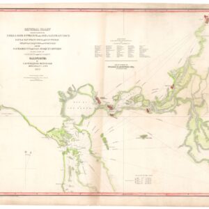
Map of Thermalito Butte County California | Map of South Thermalito Butte Co. Cal. Surveyed in April & May 188. By Bush & McCaustland. | Map of the State of Californai Showing Butte Co. and Thermalito.
$975
1 in stock
Description
This description details a unique 19th-century promotional map for Thermalito, California, a community that emerged between the late 1880s and 1895, around the time its post office was established. The map highlights Thermalito’s potential in citrus agriculture, a key economic prospect for this nascent town. Presently, Thermalito is known for its proximity to Oroville and the significant dams and hydroengineering structures nearby.
The map features three distinct components: Thermalito, South Thermalito, and a map of the state of California. It shows that while many larger lots in Thermalito were sold, residential plots were still available. South Thermalito, on the other hand, was entirely unsold and is now an uninhabited area of floodplain and parkland.
The name “Thermalito” seemingly derives from “Thermal” in California’s Coachella Valley, despite being older by two decades. Today, Thermalito is essentially a residential area within Oroville.
Interestingly, this map was created long before the completion of the Oroville Dam in 1968, a period after the Gold Rush but before the dominance of industrial agriculture and water management in Northern California’s Central Valley. The map captures this unique historical moment.
Cartographer(s):
The Thermalito Colony Co. was a key player in the development and promotion of the Thermalito area in Butte County, California, particularly in the early 1900s.
Condition Description
Folding map. Small losses at fold intersections at the cover. Map-side uncolored. Cover-side with some color printing.
References