Chatelain’s enthralled capture of the birthplace of Jesus of Nazareth.
Vue et Description de Bethleem et de Nazareth, et de Plusieurs Singularitez Curieuses qui Sevoyent dans ces Lieux Saints.
Out of stock
Description
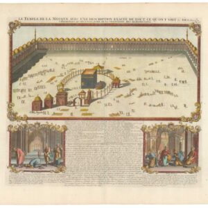
Chatelain’s view of Bethlehem, published in his seminal seven-volume Atlas Historique, is a testimony to the artistic vision that characterized him as a mapmaker. The printed area is divided into an upper and lower register, with the lower being further subdivided into smaller spaces.
At the top, we have a broad view of Bethlehem, the town in Palestine where Jesus, according to tradition, was born. The town is seen in profile from the hills outside, with the Church of the Nativity flanking the town proper. In the forefront, a scene evolves in which local tour guides lead European visitors to inspect the ruins and study the inscriptions. Chatelain deliberately taps into the excitement felt among the educated classes about the early European travelers’ rediscovery of these ancient and holy places.
The lower register is divided between an area of text describing Bethlehem, Nazareth, and the associated landmarks and four lovely vignettes underneath. These depict scenes from the Cave of Annunciation (where the archangel Gabriel supposedly informed Mary of her divine condition), the ruins of the Church at Cana (where Jesus was invited to a wedding and is said to have turned water into wine for the guests), and a view of Nazareth itself.
As European travelers and pilgrims began returning to the Middle East in the 16th and early 17th centuries, an excitement about rediscovering the Biblical past took hold among the educated classes. Chatelain’s rendition of two of the most critical locations in the New Testament should be seen in precisely that context. Yet even though broader trends and interests may have driven the selection of content, Chatelain’s talented hand captured the atmosphere of these places correctly.
Census
The copper-engraved view comes from the Chatelain family’s seminal seven volume Atlas Historique, ou Nouvelle Introduction A l’Histoire, à la Chronologie & à la Geographie Ancienne & Moderne; … Tome V. Qui comprend l’Asie en général et en particulier, l’Assyrie, l’Armenie, la Georgie, la Turquie Asiatique, la Terre-sainte, l’Arabie, la Perse, la Tartarie, les Etats Japon, et le Roïaume de Siam (1719). The atlas combines the finest engraving and cartographic craftsmanship with studies of geography, history, ethnology, heraldry, and cosmography and was one of the most widely distributed atlases in the 18th century. While not the case with this view, the maps of the Atlas Historique were primarily based on the work of French cartographer Guillaume De L’Isle. Chatelain nevertheless developed his distinct aesthetic for his maps and presented the accompanying information in an almost encyclopedic form.
Cartographer(s):
Henri Abraham Chatelain (1684 – 1743) was a Protestant pastor (Huguenot) from Paris who, due to his faith, was forced to flee his native France. He settled first in London and later in Holland, where he worked from both The Hague and Amsterdam during the early 18th century. While his primary calling was as a preacher, his Atlas Historique became a huge success, partly due to the vivacious decoration and abundance of information on his charts.
Condition Description
Very good. Some toning along edge. Slight discoloration along centerfold.
References
![[Mısır Haritası / Map of Egypt]](https://neatlinemaps.com/wp-content/uploads/2025/06/NL-02391_thumbnail-2-300x300.jpg)