Ortelius’ exquisite map of the Holy Land, showcasing the Journey of Abraham in stunning detail.
Abrahami Patriarchae Peregrinatio, Et Vita.
$2,600
1 in stock
Description
Ortelius’ map of the Holy Land, illustrating the life of Abraham, is a finely colored and highly decorative example of his cartographic artistry. Known as “The Wanderings of Abraham,” this map is among Ortelius’ most elaborate productions, showcasing his combined talents as a mapmaker, artist, and historian.
The map is a remarkable historical document. It reflects the geographical and cultural understanding of the time and provides a visual narrative of one of the most significant figures in biblical history.
Historical and Artistic Significance
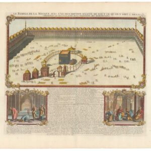
Ortelius’ map, first added to the Theatrum Orbis Terrarum in 1590, is based on the geography of the Holy Land during Abraham’s time. It features 22 medallion vignettes depicting key episodes in Abraham’s life, making it a geographical document and a visual historical narrative. The map attempts to be geographically faithful to Abraham’s era, with tribal names and territorial divisions as they were during his lifetime. Cities such as Sodom and Gomorrah are marked.
Kenneth Nebenzahl highlights the map’s significance, noting it as one of Ortelius’ most elaborate compositions, demonstrating his skills as a cartographer, artist, and historian. The map is drawn in a trompe l’oeil style, presenting it as a wall map with rollers and nails. Unlike most maps in Ortelius’ atlas, this and other maps depicting classical and ancient geography were composed by Ortelius himself, reflecting his personal interest in these areas.
Map Details
The map shows the land of Canaan, with an inset labeled “Arabia” detailing the wanderings of Abraham, the first patriarch of Judaism. The primary map depicts territorial divisions described in the Book of Genesis, with ancient tribal names, cities, significant fortifications, and geographical features. The inset traces Abraham’s journey from Ur of the Chaldees in the lower Euphrates Valley to Shechem, Bethel, Damascus, Egypt, and Hebron.
The decorative outer border contains twenty-two beautiful medallions depicting scenes from Abraham’s biblical account, such as the sacrifice of Isaac. Two decorative cartouches further embellish the map, enhancing its visual appeal.
Latin Inscription
The map includes a Latin text bordering the primary map, which translates to: “Abraham, go out from your land with your family to a land which I will show you and will give to you and your descendants after you, the land, all the land of Canaan, for an everlasting possession.”
This elaborate map of the Holy Land is based on the biblical command given to Abraham to take his family and journey to a land that would be shown to him and given to his descendants as an everlasting possession.
Cartographer(s):
Abraham Ortelius (1527-1598) was born in Antwerp to Flemish parents in 1527. After studying Greek, Latin, and mathematics, he and his sister set up shop as book dealers and a ‘painter of maps.’ In his heart, Ortelius was, nevertheless, first and foremost a historian. He believed geography was the ‘eye of history,’ which explains why he collected maps and historical documents with such passion. Ortelius traveled widely in pursuit of his interests, building contacts with mapmakers and literati all over the European continent.
Ortelius reached a turning point in his career in 1564 with the publication of a World Map in eight sheets, of which only a single copy survives. In 1570, he published a comprehensive collection of maps titled Theatrum orbis terrarum (Theatre of the World). The Theatrum is conventionally considered the first modern-style atlas. It was compiled by collecting maps and charts from colleagues across the continent, which Ortelius then had engraved in a uniform size and style. The engraver for most of the maps in Theatrum was none other than the famous Frans Hogenberg, who also served as the main engraver for the 16th-century urban atlas Civitates Orbis Terrarum, published with Georg Braun in 1572.
Hogenberg’s re-drawn and standardized maps formed the basis of the first atlas in history (even though it was Mercator who was the first to use the term a few decades later). Unlike many of his contemporaries, Ortelius noted his sources openly and in the first edition, acknowledged no less than eighty-seven different European cartographers. This ‘catalogus auctorum tabularum geographicum‘ is one of the major innovations of his atlas. The list of contributing mapmakers was kept up-to-date for decades after Ortelius’ death. In the first edition of 1570, this list included 87 names, whereas the posthumous edition of 1603 contained no less than 183 names.
While compiled by Abraham Ortelius in the manner described above, the Theatrum was first printed by Gielis Coppens van Diest, an Antwerp printer experienced with cosmographical books. Van Diest was succeeded by his son Anthonis in 1573, who in turn was followed by Gillis van den Rade, who printed the 1575 edition of Ortelius’ atlas. From 1579, Christoffel Plantin took over, and his successors continued to print Theatrum until Ortelius’ heirs sold the copperplates and the publication rights to Jan Baptist Vrients in 1601. In 1612, shortly after Vrients’s death, the copperplates passed to the Moretus brothers.
Condition Description
Very good with fine contemporary color. Some remnants of hanging tape and mat burn on the verso.
References
Nebenzahl, K. Maps of the Holy Land, no. 34; Laor, E. Maps of the Holy Land, no. 547; Van den Broeck, M. Ortelius Atlas Maps no. 183.
![[Data Visualization – Early Zionist Movement Atlas] Palästina-Wirtschafts-Atlas.](https://neatlinemaps.com/wp-content/uploads/2025/06/NL-02406-1_thumbnail-300x300.jpg)
![[Persuasive Cartography] Die Araber, Israel und die Supermächte.](https://neatlinemaps.com/wp-content/uploads/2025/10/NL-02133_thumbnail-300x300.jpg)