A magnificent view of one of America’s most majestic parks in its original envelope.
Yellowstone National Park. Northern Pacific Railway / Northern Pacific Railway Company for Yellowstone National Park Puget Sound and Alaska.
$700
1 in stock
Description
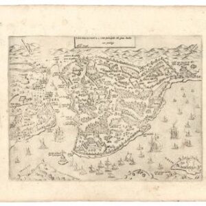
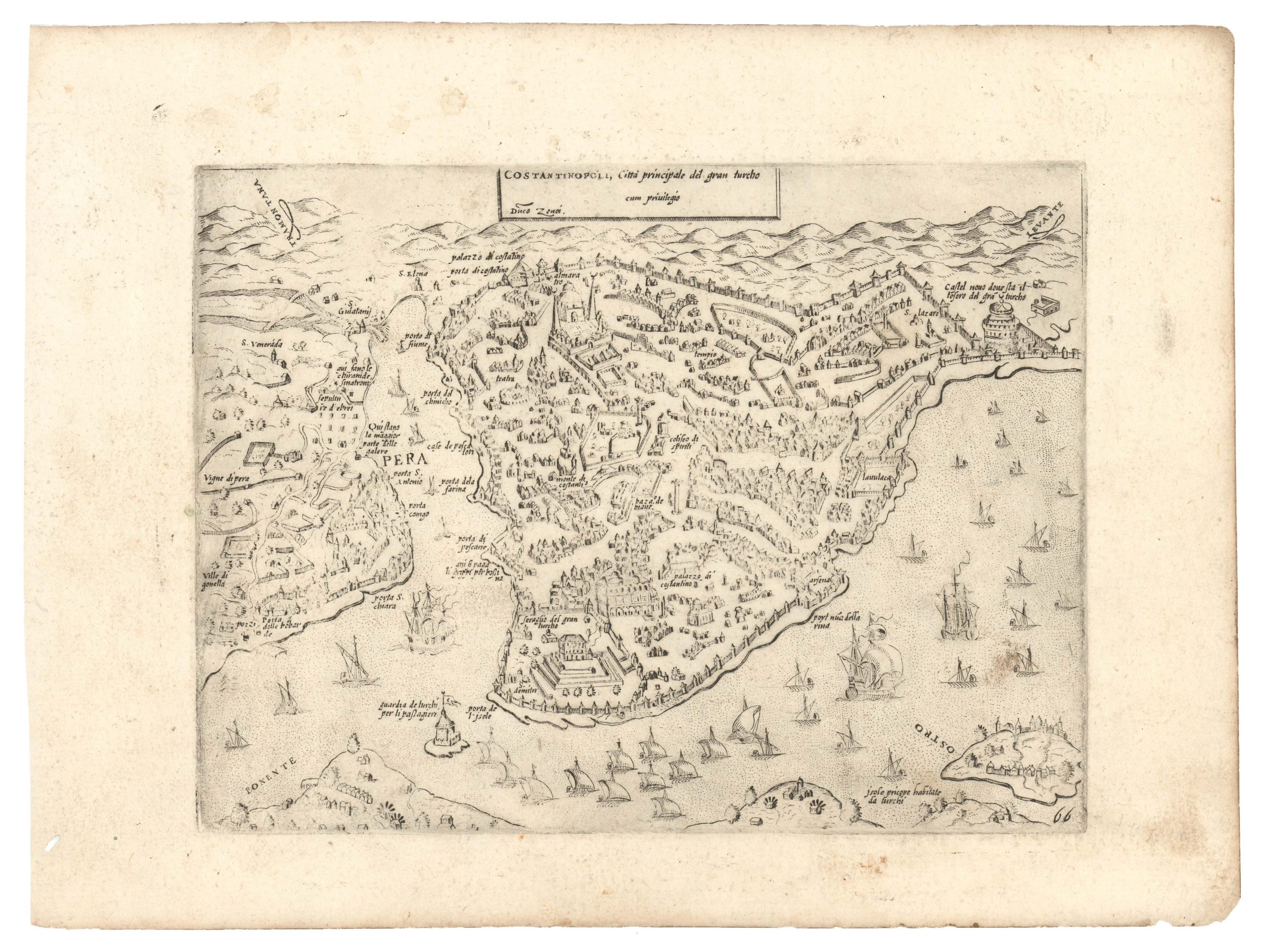
A striking bird’s-eye view of Yellowstone National Park produced by Chas. Fee of the Northern Pacific Railway and printed by Poole Bros. in 1895.
Oriented towards the north, the view covers much of western Wyoming and central Montana. In the foreground, Yellowstone Lake and other nearby lakes stand out. Mountains are labeled throughout, with their elevations noted, along with crags, ridges, plateaus, creeks, rivers, valleys, and other natural features. The lines of the Northern Pacific can be seen towards top, with the trunk line cutting east-west through Springdale, Livingston, and Bozeman, and a spur line heading towards Yellowstone to Cinabar. Major attractions such as Mammoth Springs and Old Faithful are recorded. Stagecoach roads and trails are marked within the park, with hotels (owned or partially financed by the railroad) illustrated and labeled.
The verso includes promotional text and images for Yellowstone and the railroad, information on accommodations, a table of distances for points within the park, and other practical information, as well as maps and information on the Northern Pacific’s other routes, with particular attention paid to the Alaska Route via steamer from the railroad’s terminus in Tacoma, Washington.
The Northern Pacific Railway and Yellowstone National Park
The history of the Northern Pacific Railway is deeply intertwined with Yellowstone National Park, with the railroad playing a crucial role in the development and accessibility of the park. The Northern Pacific Railway was chartered by Congress in 1864 to connect the Great Lakes with the Pacific Ocean, but construction was slow, and the entire line between Duluth, Minnesota, and Tacoma, Washington, was only completed in 1883. As for Yellowstone, though it was established in 1872, actually getting there was an arduous and hazardous journey. Although a government superintendent theoretically oversaw the park, managing such a vast territory (over 2 million acres) was nearly impossible, with squatters regularly farming, poaching buffalo and other animals, or otherwise exploiting what was meant to be protected land. Native American bands still inhabited or moved through portions of the park as well, leading to periodic conflicts with the U.S. Army, which was also stationed there.
In 1883, the Northern Pacific built a station at Livingston, Montana (near the top here), which was soon afterward extended to Cinabar (Cinnabar) and later (1902) to Gardiner, on the Montana-Wyoming border, adjacent to Mammoth Hot Springs, from which they could take a stagecoach along the rough and dusty roads seen here. This became the primary means by which travelers would reach and explore the park for the next two decades and immediately increased the annual number of visitors from the low hundreds to over 5,000 in 1883. Recognizing its monopoly on (relatively) access to the park, the Northern Pacific heavily promoted tourism to Yellowstone, building associated hotels, lodges, and other tourist facilities as well.
By the early 20th century, the Northern Pacific faced competition from other railroads reaching different sides of the park and from automobiles after they were allowed into the park in 1915, quickly displacing horse-drawn carriages and stagecoaches. The rise of the automobile diminished the appeal of train travel to Yellowstone, but the Northern Pacific had been critical to the early years of the park’s history and of the national parks more broadly, helping to launch the concept of nature tourism.
Census
This view was published for several years in the 1890s by Poole Bros. for the Northern Pacific, though not always with a dated copyright. Even examples dated to 1895 have variations in the images, text, and title panel on the verso (as well as using “Northern Pacific Railroad” instead of “Railway” on the title at the bottom of the recto).
These facts, along with the intermingling of digital and physical examples, have led to some confusion in cataloging, but the present view (regardless of verso content) dated to 1895 appears to be held by about ten institutions in the OCLC.
Cartographer(s):
Charles Sumner Fee (1843 – 1923), often as Chas. Fee, was a railroad manager who spent much of his career with the Northern Pacific Railroad. Born in Ohio, Fee began working on railroads in Michigan before landing a position with the Northern Pacific in 1877. He rose through the ranks there to become Passenger Traffic Manager before moving to the Southern Pacific Railroad in 1904. He would spend the rest of his career with the Southern Pacific’s San Francisco office, helping to plan the 1915 Panama-Pacific Exposition.
Poole Bros.Poole Brothers was a prominent map publishing and printing company based in Chicago, Illinois, known for its extensive production of railroad maps, timetables, and promotional material. Founded by George Amos Poole in the late 19th century, the company became one of the leading map publishers in the United States during a time when rail travel was the primary mode of long-distance transportation.
Condition Description
Some wear along fold lines. Minor tape repairs on verso, pinholes in upper corners. Accompanied by original envelope.
References