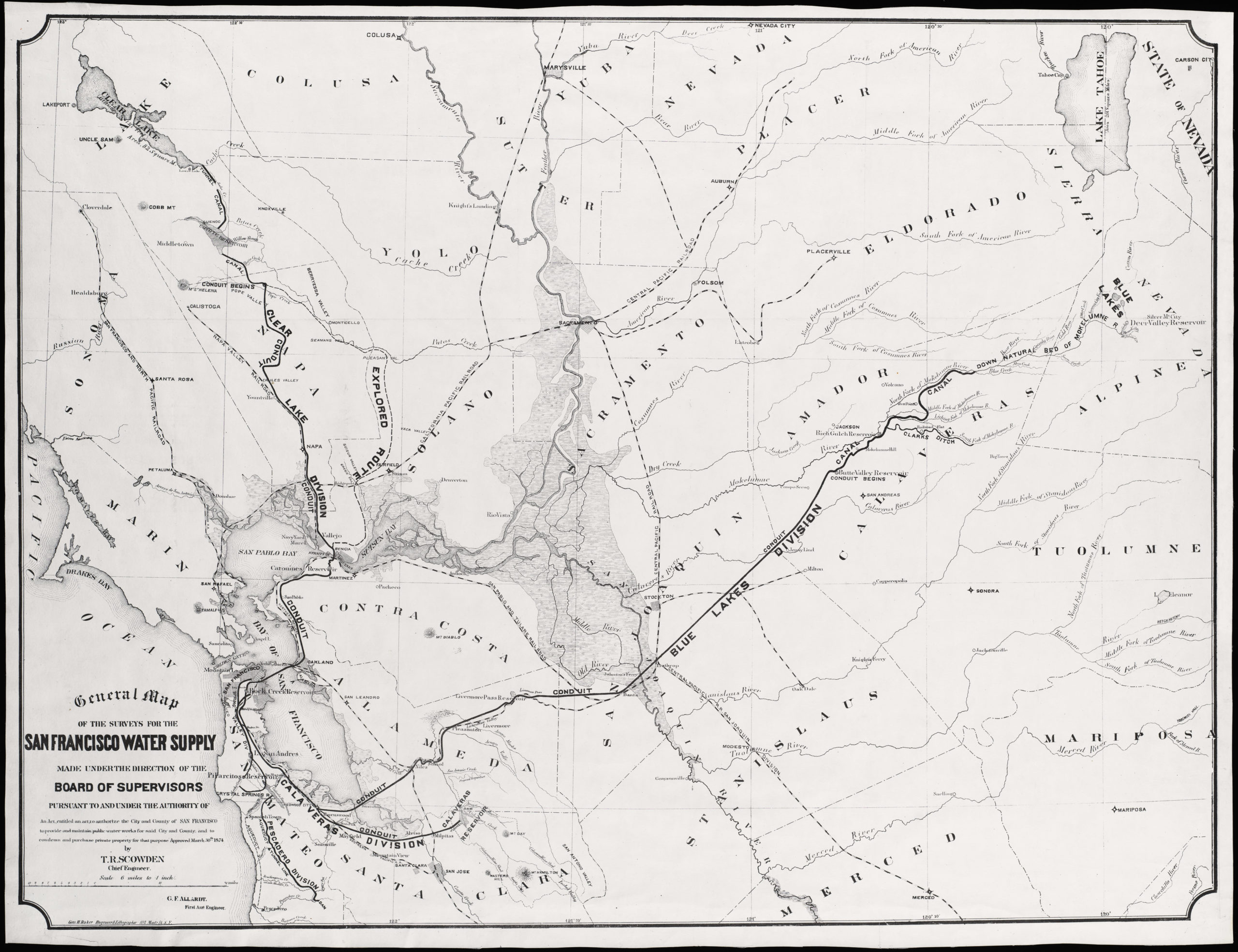
Edward Prather’s 1914 cadastral map of the Crocker Highlands development in Oakland.
Properties in Crocker Tracts, Crocker Terrace and Crocker Oaks.
$650
1 in stock
Description
This is a scarce cadastral map promoting the new residential developments of Crocker Highlands in the Oakland Hills. This area was developed for residential purposes in the early decades of the twentieth century. It was named for the influential Crocker Family, who had won enormous wealth through their involvement in expanding California’s railroad infrastructure.
From its inception, the neighborhood was conceived as an upscale residential community in which the latest architectural and planning trends were merged with the beauty of the natural landscape. Developing the area in this fashion required a phased approach, resulting in distinct subdivisions. As our map was produced at the tail end of this development, these subdivisions remain in place. The map delineates and distinguishes between the three main zones of development: Crocker Tract, Crocker Terrace, and Crocker Oaks.
Several plots around Florada and Portal Avenues have been colored in red pencil, suggesting that the map’s original owner was interested in acquiring multiple adjacent lots here. Today, these specific lots remain occupied by impressive private homes. At the time of this map’s creation in 1914, the area across the street from these highlighted lots had not yet been subdivided for residential occupation. This remains the case to this day, with the area around the Oakland Davie Tennis Stadium being the only undeveloped greenery remaining on this side of the Oakland Hills.
Census
This early cadastral map was compiled by E.C. Prather and published in 1914. It was produced on a commission from real estate developers Wickhams Havens Inc., who the Crocker Family had put in charge of development and lot sales. Wickham Havens was also involved in the original development and sale of neighboring East Piedmont Heights.
The map is scarce. OCLC records only two U.S. institutional holdings: UC Berkeley and the California Historical Society (no. 24597891).
Context is Everything
Oakland experienced rapid urban growth and improved transportation infrastructure during the early 1900s. The Crocker Family recognized this as an opportunity to transform part of their expansive landholdings into a carefully designed suburb where the built and natural environments merged seamlessly. To achieve this, property developers drew spacious lots along winding streets that followed the landscape’s natural contours.
The Crocker Tract represents the earliest phase in the development. In the first decade of the 20th century, the Crocker Family worked with local development professionals to subdivide this part of their enormous estate. The timing was opportune. Introducing a reliable streetcar service connecting the Oakland Hills to downtown significantly increased demand. With the large plot size, sales were mainly oriented toward affluent buyers. Lot sales in the Crocker Tract were conducted through the traditional channels of the day, including newspaper advertisements and real estate agents, which underscored the exclusivity and quality of the offering. This cadastral map is part of that process. Wealthy buyers were enticed by the promise of generous plot sizes, architecturally distinctive homes, and a setting exploiting natural topography.
Buoyed by the success of the initial development, planners quickly expanded the community with two additional subdivisions. Crocker Terrace, developed soon after the Crocker Tract, offered new large plots along streets designed to maximize scenic vistas. As with the Tract, local real estate professionals managed the sale of these lots through carefully staged marketing campaigns that emphasized the design’s aesthetic and functional merits.
Crocker Oaks, the third major subdivision, continued this booming trend and solidified the neighborhood’s reputation as an upscale part of Oakland. This zone was named after the ubiquitous oak trees that once were a hallmark of the East Bay Area. The same principles were applied to developing Crocker Oaks: generous plot sizes, streets laid out to complement the undulating terrain, and an overall sense of privacy and exclusivity.
Crocker Highlands benefited from a strategic marketing and sales approach throughout its early development. Lot releases were staged over several years, allowing the developers to maintain control over the pace of growth and ensure that each phase met their high planning and construction standards. Advertisements through real estate brokers highlighted the opportunities on offer, and this map is part of that promotional repertoire.
This evocative and historically crucial cadastral map is a testament to the Crocker Family’s foresight and local developers’ expertise. By deliberately subdividing and selling the Crocker Tract and expanding into Crocker Terrace and Crocker Oaks, the Oakland Hills neighborhoods set a high bar for the city’s suburban development in the future.
Cartographer(s):
Edward C. Prather (1872–1938) was a mapmaker and surveyor active in early 20th–century California. Specializing in detailed land surveys, Prather was critical in planning and developing the Bay Area’s emerging cities. His precise maps and innovative measurement techniques provided reliable data for urban planners and developers during rapid growth. Among the surveyed urban development projects are the Crocker Highlands developments, Peralta Heights, and Thermal Hill inside Oakland. He also worked extensively on projects in and around Alameda, including Elmhurst, the Brooklyn Township, and Pleasanton.
Prather’s work was marked by technical accuracy and the latest surveying methods, allowing his maps to become highly collectible historical records of Northern California’s evolving landscapes.
Wickham Havens Inc.Wickham Havens Inc. was a property agent and real estate development company founded by Wickham Sayre Havens (1874–1934), the son of Frank C. Havens, a key figure in Oakland’s early development. Wickham Havens significantly shaped several Oakland neighborhoods, including Crocker Highlands, East Piedmont Heights, and Glenview.
The company’s developments focused on creating well-planned residential areas, many of which are still recognized today for their historical and architectural value. Wickham Havens was crucial in expanding Oakland’s residential landscape during the early 20th century.
Condition Description
Backed on linen.
References