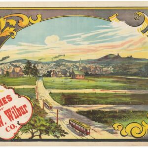
Earliest recorded printed map to locate the site of the world’s first professional baseball game.
Fort Wayne Guide Map (location of First Professional Baseball Game shown).
$6,500
1 in stock
Description
With an extremely rare depiction of the Kekionga Ball Grounds — the birthplace of professional baseball in America.
Harvey C. Lowrie’s Fort Wayne Guide Map of 1871 offers a comprehensive and detailed representation of Fort Wayne, Indiana, at a critical juncture in its history. Created during a period of rapid urbanization and industrial growth, the map captures the intricate layout of the city, showcasing not only its streets and neighborhoods but also key civic institutions, transportation routes, and significant landmarks.
Most importantly, this map has a unique place in sports history. It is one of the few surviving documents to pinpoint the location of the Kekionga Ball Grounds, immortalizing the site of the first professional baseball league game, the same year this map was published. No photographs or sketches of the ballpark have survived, and this map is the only known printed document that clearly references the ballpark’s boundaries, giving it a special place in the study of early baseball history.
The boundaries of the grounds, located on the west side of the map on the north side of the St. Mary’s River, bounded by Mechanics Street, west of the St. Marys River, are not well known, other than as shown on this map. The area may have included additional property leased by the team, though no surviving documentation clarifies whether specific lots were part of the legal description.
Creation of the Map: Context and Purpose
The map was compiled and published by Harvey C. Lowrie and printed by the Chicago Lithographing Company in 1871.
Lowrie’s motivation for creating the map would have been multifaceted. Fort Wayne was a burgeoning city at the crossroads of major transportation routes, and there was a demand for accurate, up-to-date maps for planning, business, and urban management purposes. Additionally, the map served as a commercial venture; such maps were often printed with advertising on the reverse. Lowrie’s map is no exception, containing numerous advertisements for local businesses.
The map contains many historical curiosities. It depicts the location of the old Fort Wayne site, various public schools, early businesses, and recreational spaces like the Old Skating Park. It features several prominent railroads, which were vital to the city’s economic growth. These include the Grand Rapids & Indiana Railroad, the Fort Wayne, Jackson & Saginaw Railroad, and the Pittsburg, Fort Wayne & Chicago Railroad.
These railroads and proposed and abandoned lines highlight Fort Wayne’s importance as a transportation hub in the Midwest during the late 19th century. Other notable details include the Wabash & Erie Canal, the canal feeder, and a basin between the fifth and ninth wards, reflecting the city’s connection to water-based trade before railroads took center stage.
The First Professional Baseball Game
Fort Wayne holds a special place in the history of American sports, specifically baseball, as the location of the first-ever professional baseball game. On May 4, 1871, the Fort Wayne Kekiongas faced the Cleveland Forest Citys in what is widely regarded as the inaugural game of professional baseball under the newly established National Association of Professional Base Ball Players. The Kekiongas won the game 2-0, with pitcher Bobby Mathews throwing a shutout.
The game occurred at the Kekionga Ball Grounds, a modest facility on the west side of the St. Mary’s River. According to Lowrie’s map, the ballpark was bounded by what is now Huron Street and was situated just north of the city’s fairgrounds. The site of the game is of immense historical importance, as it marks the formal beginning of professional baseball. This sport would grow to become deeply woven into the American cultural fabric.
The ballpark, constructed in 1870 on the grounds of Camp Allen — a former Union Army camp — was a simple affair. It included a covered grandstand known as the Grand Dutchess, which provided seating for spectators, particularly women and their male companions. Unfortunately, the grandstand was destroyed by fire later in 1871, and the Kekionga Ball Grounds hosted only eight more professional games before the team disbanded.
Despite its brief use, the Kekionga Ball Grounds’ association with the first professional baseball game gives it an enduring legacy. By marking the location of this early baseball site, Lowrie’s map constitutes an essential historical document not only for those interested in Fort Wayne’s history and development but also for baseball enthusiasts tracing the sport’s origins.
Census
Lowrie’s map is very rare, and no examples have been identified by the OCLC or on the open market.
An article by Bill Griggs and Jim Nitz on the website of the Society For American Baseball Research discusses the importance of Lowrie’s map in some detail: https://sabr.org/bioproj/park/kekionga-ball-grounds-fort-wayne/
Cartographer(s):
Harvey C. Lowrie was an American mapmaker and civil engineer active in the mid-19th century. He is best known for his cartographic work on the Midwest, particularly his 1871 Fort Wayne Guide Map. While little is documented about his early life, Lowrie’s contributions to urban cartography became significant during rapid urbanization in the United States. His work focused on creating accurate and functional maps for emerging cities, which are crucial for infrastructure planning and development. His work continues to be referenced by historians and collectors for its accuracy and attention to detail.
Condition Description
Folding map w/ booklet. Minor discoloration/staining along one fold.
References