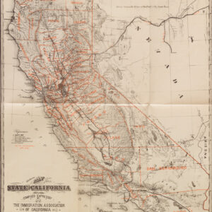
Fascinating manuscript map of the American River capturing the Sacramento Valley from Sacramento to Folsom.
Official Map of the American River in Sacramento County, California.
Out of stock
Description
This unique 1902 manuscript map shows the American River from Sacramento to Folsom. It is stamped and inscribed by the Risdon Iron Works, a company that produced mining equipment and the original builder of the Sacramento and Placerville Railroad.
The map offers an abundance of exciting details:
1. Along the southern bank of the American River, we see the Sacramento and Placerville Railroad (S&P RR). This rail line was originally chartered in 1852 as the Sacramento Valley Railroad, making it California’s first standard-gauge railroad. Built to transport gold, lumber, and agricultural goods, it connected Sacramento to Folsom, with plans to extend to Placerville, though it never fully reached its destination. Serving mining and farming communities, the railroad played a crucial role in early California commerce. Over time, sections of the line were abandoned or repurposed, with parts now used for tourist excursions, biking trails, and light rail projects, preserving its historical legacy.
2. North of Folsom, a large label reads MISSSISSPPPI. This refers to Mississippi Bar, a significant Gold Rush-era mining site along the American River, named after miners from Mississippi who worked there in the 1850s. Initially a hub for placer mining, it later saw hydraulic mining operations as prospectors sought to extract gold from its gravel deposits. As gold mining declined, the area transitioned to gravel and aggregate mining for construction. Today, Mississippi Bar is part of the Folsom Lake State Recreation Area, offering hiking and horseback riding trails, with remnants of its mining history still visible in the landscape.
3. Southwest of Folsom, the Natoma Water and Mining Company is marked. This company was established during the California Gold Rush, playing a vital role in gold mining, water distribution, and land development in Sacramento County. Originally created to supply water for hydraulic and placer mining in areas like Folsom and Mormon Island, the company built an extensive network of canals, flumes, and reservoirs. As gold mining declined, it transitioned to irrigation and land development, supporting agriculture and settlement in the region. Its legacy remains in the remnants of its water infrastructure, some of which still influence the area’s water systems today.
4. Nearby, a label in large letters reads GRANITE. Granite is abundant near Folsom, California, particularly Folsom Granite, a durable gray granodiorite that was widely quarried in the 19th and early 20th centuries. It was used in major construction projects, including Folsom State Prison, the California State Capitol, and curbstones in San Francisco. The region’s quarries supplied high-quality stone for bridges, buildings, and infrastructure, and while large-scale quarrying has declined, remnants of old quarries and Folsom granite can still be seen in historic structures and local landscapes today.
5. The Branch State Prison marked outside Folsom refers to Folsom State Prison, one of California’s oldest and most historically significant penitentiaries.
6. At the eastern edge of the map, we see Mormon Island. This was a thriving Gold Rush, founded in 1848 by Mormon prospectors who discovered gold in the American River. It quickly grew into a bustling town with businesses, schools, a hotel, and a post office, becoming one of California’s most successful mining camps. However, as gold resources dwindled, the town declined, and in the 1950s, it was submerged beneath Folsom Lake following the construction of Folsom Dam. Today, remnants occasionally resurface during droughts, and a historical marker commemorates its legacy as an important yet fleeting Gold Rush community.
7. A final note should be made on the presence of survey coordinates from the Public Land Survey System (PLSS), a broadly used surveying system that allowed for dividing large tracts of land into manageable sections for legal or mapping purposes. PLSS markings like “T. 9 N. R. 6 E.” can be decoded as follows: T. 9 N. Refers to Township 9 North, indicating an area in the 9th township north of a baseline. A township is a 6-mile by 6-mile square area of land. R. 6 E. or Range 6 East, refers to the 6th range east of a principal meridian, a north-south line used for surveying. In unison, PLSS coordinates pinpoint specific locations in a grid system based on a specified principal meridian.
Cartographer(s):
Condition Description
Very good. Manuscript on drafting linen.
References