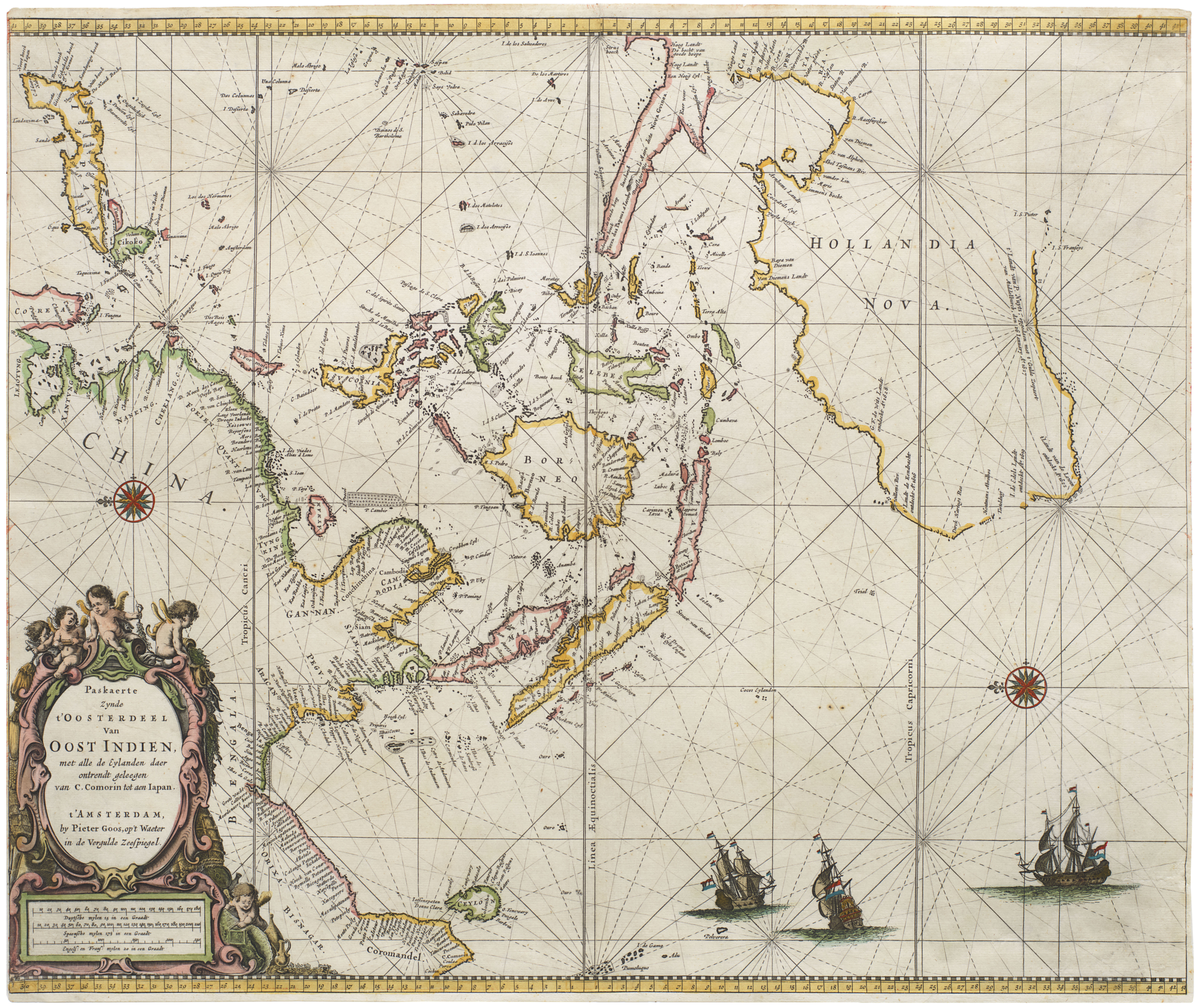
The first large-format view of Sydney.
The City of Sydney.
Out of stock
Description
The finest view of Victorian Sydney ever produced.
This superb chromolithographed bird’s-eye-view of Sydney was drawn by M.S. Hill, a local artist active in the 1880s. Published in New York and Sydney by the Samuel Crump Label Co. for the centennial year of Australia’s settlement, this panoramic view captures Sydney at the height of its Victorian prosperity and splendor.
The map’s oblique aerial perspective and meticulous detail provide an impressive overview of the bustling colonial metropolis. The view is celebrated both for its artistic and historical significance, and boasts many “firsts” and “only-s.” The entire 1888 Sydney skyline is on display, complete with church spires, smokestacks, and the domes and towers of important civic buildings.
Hill’s panorama is drawn from an imaginary vantage point high above Port Jackson and looking south. In the foreground, we see the eastern headlands dominated by Circular Quay and the Sydney Harbour front. Beyond this, the cityscape unfolds in a grand vista of Sydney’s inner city and suburbs. To the right (west), the panorama sweeps over Darling Harbour, the waterfront at Barangaroo, and the suburban peninsulas of Balmain, with the Parramatta River estuary just visible in the distance. On the left (east) is the wooded expanse of the Royal Botanic Garden, beyond which the outlying districts stretch out toward Botany Bay on the horizon.
The harbor is alive with activity, befitting a major colonial port. Boats of all descriptions plow the harbor waters: from square-rigged sailing ships to steamers trailing plumes of smoke. Circular Quay – the city’s principal wharf – is lined on all three sides with piers, vessels, and waterfront warehouses, underscoring the importance of maritime commerce for the city. Ferries and smaller craft criss-cross the water.
The bustling waterfront is rendered in such detail that one can discern individual figures on the wharves and cargo on the docks. At the inner harbor’s edge, Bennelong Point is depicted with a small stone fortification extending into the water. This is the old Fort Macquarie, which would be demolished in 1901 to make way for a new tram depot. This, in turn, would later become the location of Sydney’s famous Opera House. The inclusion of Fort Macquarie is but one example of the vanished landmarks preserved in this view.
Hill identifies major landmarks and institutions within the dense cityscape. In the central business district near Circular Quay, one can spot the Customs House (still standing today at the Quay’s eastern end) and the clock tower of the General Post Office on Martin Place. Not far away, the twin towers of St. Andrew’s Cathedral rise above the surrounding rooftops. This Anglican cathedral was a centerpiece of colonial Sydney. The grand Sydney Town Hall, completed only a few years earlier, is also rendered with its distinctive dome and clock.
The green swath of Hyde Park is depicted, along with hints of the freshly dedicated Centennial Park in the distance. To the east, the Royal Botanic Garden and Government Domain appear as a green band along the harbor. This is where the Garden Palace would have stood, but it famously burned down in 1882, leaving only a visible footprint of three concentric walkways.
Hill fills his scene with rich details. Rows of terraced houses and city blocks are drawn with such fidelity that the view almost takes on cartographic properties. The railway yards and industrial structures at Darling Harbour can be discerned on the western side, and one can even see the depot near Bridge Street, where the city’s steam trams were housed. Here and there, plumes of smoke rise from factory chimneys and locomotives, conveying a sense of modern industry.
To a degree, the view blends documentary accuracy with artistic license. This is most evident in the depiction of St. Mary’s Cathedral, which is drawn with its two Gothic spires, even though these were not completed until much later. Presumably, Hill took the liberty of showing St. Mary’s as it was intended, thereby “improving” Sydney’s skyline. This speaks to a broader ambition that led to a slight utopian flair, as if showcasing not only the city that is, but also the city it aspired to be. The view captures Sydney on the cusp of modernization, but still without its electric trams and telegraph wires. It conveys both the grandeur of Sydney’s natural setting and the energy of its urban growth.
Census
The City of Sydney was drawn and published by M.S. Hill in 1888, with printing handled by the New York-based Samuel Crump Label Co. The print is explicitly dated “Copyrighted Sep. 3, 1888” on the image margin, indicating that Hill secured copyright on that date.
Only a handful of institutional copies have been recorded. The National Library of Australia holds a copy (Nan Kivell Collection, NK2109) and lauds the work as “one of the great pictorial maps of Australia.” The State Library of New South Wales in Sydney also holds an original, noting the map’s extraordinary detail and centennial significance. In the United States, the Jay T. Last Collection (Huntington Library, California) holds an example. Beyond these, surviving originals are scarce.
In terms of other views, a contemporary, but slightly earlier, counterpart was produced by Albert Charles Cooke and Samuel Calvert. This was published in January 1888 in the European edition of Illustrated Sydney News (see https://catalogue.nla.gov.au/catalog/2713220). This is the only other 1888 color bird’s-eye representation of Sydney known, but it is smaller, of much poorer quality, and printed on magazine paper, so not really comparable, in my opinion.
There are several panoramic views associated with the Sydney International Exhibition (1879–1880), but most depict specific buildings on the fairgrounds within the Royal Botanic Gardens.
Then there is the considerably earlier folio, Joseph Fowles’ Sydney Illustrated (1848), which contains some of the earliest panoramic lithographed views of Sydney. Many surviving examples are hand-colored. These are very important both artistically and historically, but they are prospect views from specific vantage points, not bird’s-eye-views of the city as a whole.
And finally, there are several folding tourist maps of Sydney in various perspectives. But these start around 1890, so are both later and again not really comparable.
The rarity on the antiquarian market cannot be overstated: when examples do surface, they tend to be met with strong demand. The combination of its large format, full-color printing, and folding-map construction meant many copies were prone to damage or loss, so an intact example in good condition is extremely scarce and desirable.
Context is Everything
In 1888, Sydney celebrated the centenary of the First Fleet with a week of public holidays, parades, fireworks, regattas, and the dedication of Centennial Park by Sir Henry Parkes. A statue of Queen Victoria was unveiled before 50,000 people, symbolizing imperial pride. The festivities completed the city’s transformation from penal outpost to booming metropolis.
Sydney’s growth was indeed remarkable, from a few thousand settlers in 1788 to just under 100,000 in 1861 and nearly 400,000 by 1888. Gold wealth and an 1880s land boom fueled this expansion considerably, allowing Sydney to begin rivaling Melbourne as Australia’s largest city. Hill’s view shows the city at the height of a boom that soon gave way to the 1890s depression. His depiction of grand banks, insurance offices, and government buildings reflects the era’s wealth and ambition, while the compact centre and emerging tram‑line suburbs illustrate the evolving urban fabric.
The map also mirrors the political and social context. New South Wales remained a self‑governing British colony, yet a distinct Australian identity was gradually taking shape. Parkes, who dedicated Centennial Park, would call for federation the following year. The centennial celebrations explicitly excluded Indigenous Australians, a silence that is echoed on the map. Instead, we have the physical imprint of British colonization: churches and cathedrals, colonial government offices, and busy commercial districts around George Street and Circular Quay.
Artistically, Hill’s print belongs to the 19th‑century tradition of panoramic city views that flourished with the rise of affordable chromolithography. While bird’s‑eye-views were popular in North America and Europe, few were ever produced in Australia, making Hill’s view all the more unique. Earlier Sydney illustrations include a centennial engraving in the Illustrated Sydney News and images of the 1879 International Exhibition, but none approached the size or richness of Hill’s masterpiece. It is generally regarded as the first full‑color bird’s‑eye-view of Sydney and rivals the best American examples. After 1888, grand hand‑drawn panoramas declined as photography advanced, and pictorial maps of the early 20th century were far more schematic.
Hill’s 1888 view thus stands as the crowning achievement of its genre in Australia.
Cartographer(s):
M.S. Hill is most likely Marcus Stow Hill, born in Illinois in 1859. Hill married an Australian woman and moved there. That the view was made by an American makes sense, as viewmaking like this was very much an ‘American’ art. He appears to be something of a dilettante, primarily involved in various business ventures and inventions, not an artist, but likely a capable draftsman, given his engineering inventions.
Samuel Crump Label Co.The Samuel Crump Label Co. was a late-19th-century American lithographic printing firm based in New York that specialized in high-quality chromolithography for commercial and decorative purposes. Like many firms of the period, it produced product labels, advertising ephemera, pictorial prints, and work requiring technical expertise in multi-stone lithography.
Chromolithography reached its peak in the 1870s, and companies such as Crump’s catered to a growing international market for richly colored printed materials, including maps, views, and promotional graphics. The firm’s imprint appears on a variety of surviving labels and illustrated works of the 1880s, indicating that it possessed the equipment and labor force necessary for complex color printing on a large scale.
Condition Description
Dissected and mounted on linen, some surface dirt and minor marginal repairs to extremities, notably upper margin, with repaired tear in the lower lettered margin to centre, folding with green paper end with Liverpool Public Library label to upper cover, folding into modern boards, upper cover gilt, 4to.
References