1693 Collins Nautical Chart of Plymouth Sound.
[Plymouth Sound]
Out of stock
Description
England’s Great Naval Harbor, Charted at the Height of Its Power
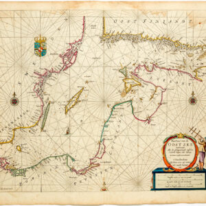
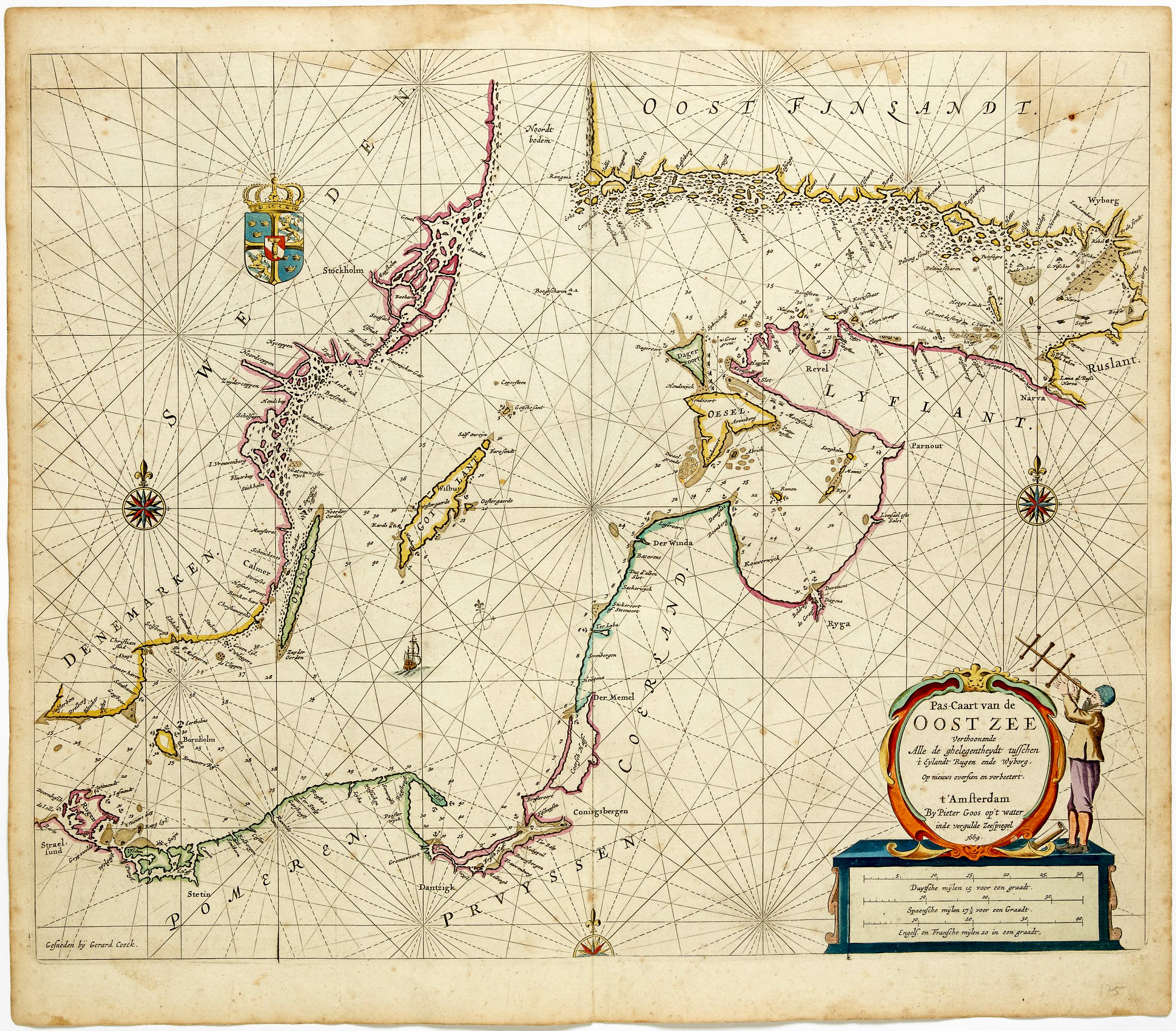
This finely engraved sea chart from Captain Greenville Collins’s Great Britain’s Coasting Pilot of 1693 depicts Plymouth Sound and its immediate approaches, one of the principal naval anchorages of southwest England. The plate is dedicated to the Earl of Torrington, reflecting both the chart’s scientific ambitions and its close entanglement with naval authority in the years immediately following the Glorious Revolution.
The Map in Detail
The chart extends from the Rame Peninsula across the Hamoaze and Cattewater to the estuary of the River Tamar as far inland as Saltash. Coastal settlements including Cawsand, Wembury, Hooe, and Newton Ferrers are carefully delineated, while the harbor of Plymouth itself is shown as the focal anchorage. Soundings, shoals, and navigational hazards are meticulously plotted, while an intricate network of rhumb lines radiates across the sea, anchored by compass roses along the lower margin. The composition is further animated by small sailing vessels and an elaborate dedicatory cartouche honoring the Earl of Torrington.
To the right, an inset chart provides a more detailed treatment of Salcombe and the Kingsbridge estuary, a secondary but strategically important harbor. This inset underscores the sheet’s dual function: it is not merely a coastal overview, but a practical navigational aid for entering specific anchorages. The combination of regional coverage and localized detail exemplifies the structure of Collins’s charts, in which subsidiary plans supplement the treatment of major ports.
Historical Context
Plymouth had long been the principal gateway between England and the Atlantic, the harbor from which Drake had sailed to meet the Armada, and from which the Mayflower had departed for the New World. By the time Collins was conducting his surveys in the 1680s, it had also become one of the Royal Navy’s most critical strategic bases, its position at the southwestern tip of England making it the first port of call for returning fleets and a vital staging point for operations in the Channel and beyond.
The dedication to Arthur Herbert, 1st Earl of Torrington, situates the chart within the political world of the new Williamite establishment. Herbert had commanded the English fleet that escorted William of Orange’s invasion force across the Channel in 1688, and was rewarded with the earldom and the position of First Lord of the Admiralty. His subsequent court-martial following the Battle of Beachy Head in 1690, in which a combined Anglo-Dutch fleet was bested by the French, ended his active career, but his association with the Revolution’s success made him a natural patron for a chart of this kind. The overall effect is a highly legible and visually rich rendering of one of southwest England’s principal commercial and naval harbors at a pivotal moment in British maritime history.
Publication History and Census
This chart appears as a plate in Great Britain’s Coasting Pilot, first published in London in 1693. The plates were reprinted throughout the eighteenth century by the Mount publishing dynasty, first as Mount & Page and later as Mount & Davidson, and surviving sheets are most commonly encountered as individual disbound leaves.
Cartographer(s):
Captain Greenville Collins (c. 1643–1694) was an English naval officer and pioneering hydrographer whose work laid the foundation for systematic coastal charting in Britain. Serving in the Royal Navy during the late seventeenth century, Collins gained practical experience in navigation and surveying at a time when reliable nautical charts of British waters were scarce. Recognizing the strategic and commercial importance of accurate maritime information, the English crown commissioned him in the early 1680s to conduct a detailed survey of the coasts of England and Wales.
Between roughly 1681 and 1688, Collins directed an extensive hydrographic survey of the English coastline, measuring depths, mapping shoals and sandbanks, and documenting harbors and navigational hazards. His work represented one of the first coordinated national charting efforts in England. The results were compiled into Great Britain’s Coasting Pilot, first published in 1693. The volume combined detailed engraved charts with sailing directions and coastal views, providing mariners with far more reliable guidance than previously available.
Collins’s atlas became the standard reference for navigation around British waters for decades and marked an important step in the professionalization of hydrography in England. His methods and charts influenced later surveying practices and helped improve maritime safety during a period of expanding naval power and overseas trade. Collins died in 1694, only a year after the publication of his landmark work, but his contributions established him as one of the earliest significant hydrographers of the British Isles.
Condition Description
Wear along the centerfold and margins. Image is nice.
References