A cartographic rarity from the Armée coloniale in French West Africa.
Senegal Fleuve de St. Louis aux Chütes du Félou.
Out of stock
Description
A Historical Marvel: The first hydrographic map of the Senegal River, compiled by an indigenous African mapmaker in the service of the French colonial army.
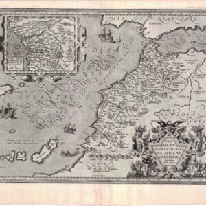
Produced on the cusp of a new century and during the height of French colonial rule in West Africa, this map charts the course of the majestic Senegal River from the capital to its furthest navigable point at the Chûtes de Félou. It constitutes the first hydrographic map of the Senegal River ever made.
Colonial officer Auguste Pujol commissioned the map, which was presumably published in St Louis, the vibrant capital city of Afrique-Occidentale Française. The cartography is based on pioneering surveys of the region conducted by Henri Pierre Gabriel Buchard between 1891 to 1893.
An innovation in cartographic craftsmanship and design
One of many features that sets this map apart is its stunning design, which balances utility and accuracy with an elegant aesthetic. The main map stretches across the page as a foundational layer in the composition. It follows the river, cutting diagonally from the upper left to the lower right corner. Nevertheless, the true innovation in design lies in the 31 meticulously rendered inset maps, which have been cleverly overlaid on the main map to provide an impressive degree of highly localized detail. In this sense, the map almost appears as an analog prototype of the advanced GIS mapping used by hydrographers today.
The insets are visually presented as distinct charts with individual artistic detail. In unison, the symphony of cartographic images creates a three-dimensional effect while beautifully showcasing the riverside towns and forts. Key locations such as Saint Louis, Richard-Toll, and Bakel are prominently featured, offering an immersive glimpse into the history and geography of the region.
Helio-zincography in the Late 19th Century
The map was produced using a technique known as helio-zincography, and in many ways, its application showcases some of the technological advances in printing during the Victorian Era. Helio-zincography is a reproductive process using glass photographic negatives to create carbon-positive prints transferred to zinc plates. John Walter Osborne invented the technique in Australia around 1859, but officers of the British Ordnance Survey significantly developed it. The method significantly reduced costs and increased printing mobility as the zinc plates were much easier to handle than traditional lithographic stones. Helio-zincography consequently became a popular technique for cartographic agencies, including the British Ordnance Survey and the French Bureau Topographique.
Census
This exceptional map comes with a fascinating historical context. Henri Pierre Gabriel Buchard, a French colonial naval officer and hydrographer, played a pivotal role in charting the Senegal River, earning him the esteemed title of Officier de la Légion d’Honneur in 1906. It was these surveys that underpinned this map and ultimately allowed its creation.
The map was commissioned by August Marie Joseph Pujol, a distinguished French colonial officer who, while stationed in Senegal, held the rank of Etat-Major du Commandant Superior des Troupes Coloniales. We know that Pujol commissioned several maps of the region, including a railroad map. Credit for the remarkable design goes to A. Vandenkerckhove, a sergeant from the Tirailleurs Seneglais (Senegalese skirmishers), an all-African unit under the Armée coloniale. While we do not know the exact purpose or context for which the map was intended, it may have been a military loose-leaf atlas or official map collection.
To our knowledge, it is the only known example of its kind. It is co-owned with Geographicus in Brooklyn.
Cartographer(s):
A. Vandenkerckhove was an indigenous Senegalese soldier working for the French colonial army in Senegal. He was part of an all-African unit known as the ‘Tirailleurs seneglais’ (Senegalese Skirmishers) that was charged with the survey work and compilation of regional maps for the French colonial government. As such, he stands as one of the earliest known African cartographers.
Vandenkerckhove is essentially a Dutch name, and it is unclear why a Senegalese soldier under French rule would have such a name. He is not to be confused with the Belgian writer and mystic Auguste Vandekerkhove, who lived at roughly the same time.
Auguste Marie Joseph PujolAuguste Marie Joseph Pujol (1863-1945) was a distinguished French colonial officer who served in occupied West Africa. He was born in Camargue, France, and held several foreign postings between 1880 to 1899. These included Reunion (1885), Madagascar (1886), Senegal (1890), Sudan (1892), and Tonkin (1893 – 1903). While stationed in Senegal, he held the rank of Etat-Major du Commandant Superior des Troupes Coloniales. He is known chiefly for having commissioned several detailed topographical maps of the region.
Condition Description
Good. Soiling and discoloration along old horizontal fold. On silk-linen.
References