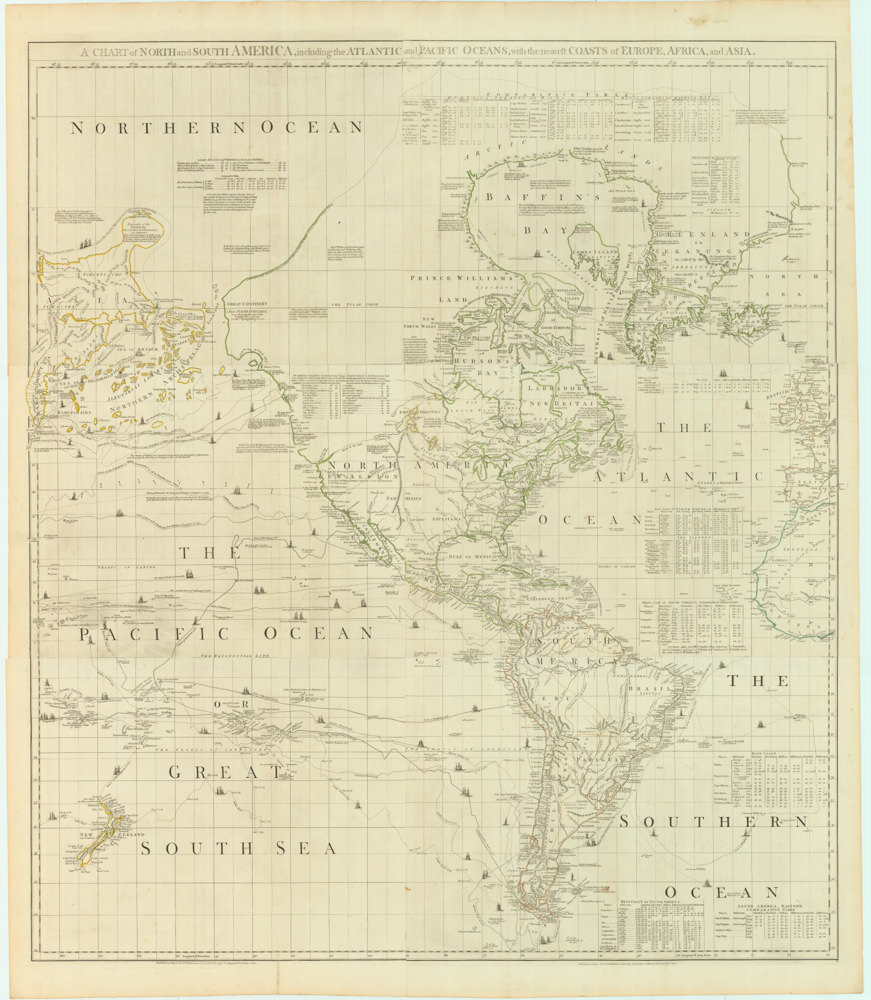
Bellin’s splendid rendition of the Americas at the end of the French & Indian War, with Le Petit Atlas Maritime‘s distinctive green tinting.
Carte de l’Amerique et des Mers Voisines.
Out of stock
Description
A gorgeous rendition of the Western Hemisphere, compiled by Jacques Nicholas Bellin, director of the French Navy’s hydrographic service and quite possibly the most significant mapmaker in the history of French cartography.
The map comes from one of Bellin’s seminal atlases, Le Petit Atlas Maritime, and includes the sublime green tinting that characterizes this specific atlas.
The map contains an abundance of information pertaining to maritime navigation. We note the detailed graticules for both latitude and longitude and the demarcation of wind and compass directions, islands, and coastal features on both continents. Historically, the map is also interesting in that Bellin captures North America at the conclusion of the French and Indian War.
Despite coastal regions being the explicit focus of this map, it is vividly clear that significant parts of these great continents remained unexplored in the 18th century. The empty and undefined Northwest Pacific is still terra incognita. Still, even along the eastern seaboard of North America, we find plenty of features that exemplify just how patchy and incomplete the geographic understanding of this region still is in the late 18th century. Greenland, for example, remains physically attached to Canada, while Baffin Bay is rendered as a gigantic fiord or closed basin.
The colonial delineations reflect similar antiquity, with France and Spain still controlling gigantic swaths of North America and British control being restricted to the East Coast and Labrador/Newfoundland. Such colonial divisions were of course dynamic and would shift regularly. More importantly, it was common for colonizers to use maps as tools for political dominion. In light of this, one must pay attention to who the author of this chart is. Bellin was one of the greatest cartographers of the era, who set new standards for hydrographically adjusted mapping. But he was also a loyal agent of France, keenly aware of the impact of his output and presumably reluctant to yield contested territory to the British.
Context is Everything
Nicholas Bellin’s Le Petit Atlas Maritime is a significant work in maritime cartography in that it essentially is an atlas focused on nautical navigation and coastal topography. The atlas was first published in Paris in 1764 but was immensely popular and was consequently issued in numerous editions and revisions throughout the 18th century. The contents of Le Petit Atlas Maritime consist of a collection of detailed maps, charts, and coastal profiles that cover various parts of the world. It also includes maps of major shipping routes, ports, and detailed navigational information, making it a valuable resource for sailors, merchants, and explorers of the time.
All the maps are characterized by Bellin’s meticulous attention to detail, accuracy, and clear presentation, making them highly reliable and widely used outside France.
The historiographic significance of this atlas lies in its contribution to advancing maritime and littoral cartography. Bellin’s maps provided mariners with essential information for safe and efficient navigation, aiding European powers’ exploration, trade, and colonization efforts. The atlas also played a crucial role in developing hydrography as a discipline due to Bellin’s insistence on accurately representing coastlines, soundings, and other nautical details.
In sum, Le Petit Atlas Maritime was a milestone in maritime cartography history, providing a comprehensive and reliable collection of maps and charts that helped shape navigation and exploration during the 18th century.
Cartographer(s):
Jacques Nicolas Bellin (1703 – 1772) was a French hydrographer, geographer, and intellectual who worked for the Ministère de la Marine from age 18. Born in Paris, Bellin was appointed to the hydrographic office of the French Navy in 1741, rising quickly through the ranks to become its chief mapmaker. He was appointed to the Académie de Marine and the Royal Society of London.
During his long career, Bellin developed new and very accurate systems for compiling coastal charts, and he became one of the most copied cartographers of the 18th century. Over the course of fifty years, Bellin produced a large number of maps for the Ministère de la Marine. His maps of Canada and French territories in North America (New France, Acadia, Louisiana) were particularly valuable because they helped secure navigation on the St. Lawrence River and formed the cartographic basis for French claims of the Great Lakes region and Mississippi River Valley. He died at Versailles.
Condition Description
Very good.
References
Tooley, Mapping America, p. 208-9. Rumsey 6903.000.


