Carte Très Curieuse de la Mer du Sud, Contenant des Remarques Nouvelles et Tres Utiles non Seulement sur les Ports et Iles de Cette Mer

$16,000

Cartographer(s): Henri Abraham Chatelain
Date: 1719
Place: Amsterdam
Dimensions: 143.5 x 84 cm (56.5 x 33 in)
Condition Rating: VG+

In stock

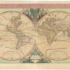
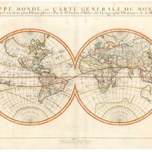
Henri Chatelain’s magnificent map of the Western Hemisphere in extraordinary color and condition.

Details

Listen to Michael introduce this map:


One of the most embellished and decorative maps of the New World to have been produced in the 18th century. A vivacious tribute to the Age of Exploration and Discovery, Chatelain’s cartographic tour-de-force merges mapmaking and graphic artistry to create an inspired masterpiece that has echoed through the ages.

This beautiful and well-preserved copy of Chatelain’s map of the Western Hemisphere is perhaps the most astonishing chart of the New World to have been produced in the first half of the 18th century. Published in Amsterdam in 1719, the map was lavishly decorated and embellished in the style and tradition of 17th-century Dutch cartography but also supersedes this tradition in many ways.

In sum, Henri Chatelain’s magnificent chart of the Western Hemisphere constitutes a decisive step in visualizing the composition of the world on paper. It was composed at a crucial stage in cartographic history, with humanity on the cusp of reaching a new and fuller geographical understanding of our world. Chatelain’s chart embodies this long journey and sets the stage for future accomplishments. It has been executed with the highest cartographic and artistic aspirations in mind and is, in the words of two renowned map scholars:

One of the most elaborately engraved maps of the Western Hemisphere ever produced

Schwartz & Ehrenberg, The Mapping of America, p.142

The compiler behind the map, Henri Chatelain (1684-1743), was born in Paris. Chatelain was a protestant Huguenot pastor and a successful businessman and publisher. Being oppressed and persecuted in his native Catholic France, Chatelain, like many Huguenots, fled to more tolerant parts of Europe; he went first to London and later to The Hague and Amsterdam. He was, in other words, heavily exposed to Dutch and English values, traditions, and aesthetics. Despite the understandable reliance on Dutch traditions in compiling his map — Holland was not only a place of solace for the Huguenots but also the center of European mapmaking — Chatelain’s imposing chart took the traditions of narrative decoration to new heights and set a new bar for the practice of ‘aesthetic mapping’.

The map comprises four joined sheets and measures 56 by 33 inches (142.5 x 83 cm). It has been lavishly embellished with abundant geographic information, pictorial narratives, and evocative imagery and has been skillfully hand-colored. The map covers an enormous stretch of the globe, extending from eastern Asia on the left side to western Europe on the right. As such, it does not just cover both the American continents but also the whole of the Atlantic and Pacific Oceans.

Nevertheless, the focus is clearly on the American landmasses and the Pacific Ocean. At the dawn of the 18th century, the region was marked by obscurity and characterized by opportunity and a lively imagination. One important aspect of this map is that it was conceptualized in an age of transition. During the first half of the 18th century, accurate geographic understanding — especially related to the Northwest Pacific and Russo-American connectivity — was still very much in its early stages. It was not until the ground-breaking Kamchatka expeditions of Martin Spangberg and Vitus Bering in the mid-18th century that a concrete observation-based geography was established for this region. Overall, Chatelain’s map constitutes one of the most refined cartographic summations of geographic knowledge as it pertained to America and the Pacific Ocean at the time.


Publication information

Chatelain’s map was originally issued as part of an enormous compendium, Atlas Historique, published anonymously in seven volumes between 1705 and 1720. Our map was part of the sixth volume (1719), devoted entirely to the Americas. It was based upon a larger but otherwise similar chart by Nicolas De Fer published in 1713.

The Atlas Historique was a modern encyclopedic geography describing the history and genealogy of each continent. The fact that it was issued anonymously is a mystery but could well be related to the troubled relations between the religious denominations of Western Europe. Nevertheless, it is established that the maps were drawn by the Chatelain family, of which Henri Chatelain was the head, the most accomplished artist, scholar, and cartographer (the other members were his father and brother, both named Zacharias Chatelain). As a mapmaker and writer, Henri Chatelain drew his inspiration from many different sources in the French, English, and Dutch schools of cartography. There can be little doubt that his most elaborate and refined maps — of which ours is the best — were drawn by himself. It is also known that the large body of text was primarily written by Nicolas Gueudeville (1652-1721), a fellow French geographer and a Benedictine Monk who had been ‘defrocked’ due to his socially indignant writings (Gueudeville is by some considered a precursor to Jean-Jacques Rousseau).

Geography, topography, and cosmography were some of the themes in the Atlas Historique. In the spirit of the Age of Enlightenment and Discovery, these themes were often augmented with ethnographic discussions of local history, peoples, and their customs, as well as notes on heraldry and lineages. In the America volume, and in particular with this map, we are invited to celebrate the Age of Discovery and all that it was perceived as having accomplished for humanity (i.e. territorial expansion, natural resources and great wealth for the Europeans, and remarkable life improvements like beads, mirrors, and Christianity for the indigenous populations).

However, Chatelain’s map is not just a celebration of exploration and discovery but also a tribute to the many wonders of the New World; this is evident at first glance. The map is exuberantly decorated and annotated to capture all of the innumerable facets of these new continents. On it, we find references to countless voyages of discovery and the brave souls that manned and led them, and thirty-five distinct decorative vignettes and map insets, which in unison, provide the viewer with a rich and deep visual experience.

Chatelain’s America chart is a metamorphosis of these two styles, in which massive amounts of textual information have been embedded visually into a cartographic whole. It makes this map truly unique, not only for its time but also for the volumes in which it appeared. The result is a masterpiece of artistic cartography, revealing the mapmaker’s self-confidence, imagination, and skill. Undoubtedly, it was also a product of which Chatelain himself was extremely proud, as the title, A Very Curious Map of the South Sea, Containing New and Very Useful Notes not only on the Ports and Islands of this Sea, but But Also On The Main Countries Of North And South America, With the Names & Route Of Travelers, would seem to suggest.


Details

This map’s scope stretches from Asia in the east to Europe and Africa in the west. It is essentially only the Indian Ocean littoral and the Eurasian landmass that preclude it from being a world map. While the Americas constitute the central landmass in the composition, the map is in many ways an oceanic chart, particularly the still poorly known Pacific. The oceans are emphasized by many features, including images of caravels and other ships sailing along plotted exploration and trade routes. All routes are labeled and associated with concrete expeditions or active mercantile circuits. Many routes are thematically linked to a series of medallion portraits occupying the Pacific Northwest of America.

In the center of the Pacific, we find a longer piece of text which delineates the ocean and describes some of its characteristics. The text has been halved by an elegant black and white graticule that demarcates the Equator and provides longitudinal degree positions. Two decisive red lines provide the latitudinal positions of the Tropics of Cancer and Capricorn. Similar bits of text are found throughout the Atlantic, but these all refer to physiographic features such as islands, reefs, or capes. The entire oceanic space is filled with islands, most of which are well known at this stage and have been rendered correctly. The further afield we go, however, the more unreliable their position and outline becomes, in some cases being entirely relegated to the realm of myth.

Oddly enough, the most exciting and essential part of the Pacific Ocean to be included on this map is the area most obscured by the map’s decorative scheme. In the early 18th century, the Northwest Pacific — particularly the physical relationship between the North American and Eurasian continents — was still a highly contested issue that was unresolved, layered with imagination and mythology, and potentially very lucrative to those who could navigate and map it correctly. The concept of a Northern Passage changed form and nature over time, but the idea goes back to the earliest days of discovery.

Our map shows that Chatelain uses the age-old technique of filling unknown spaces with inscriptions, vignettes, and other elaborations. However, Chatelain does a more elegant job of obfuscating the unknown due to the sheer quality of his visual distractions. In the watery expanse between the two continents, we find an elaborate and humorous vignette depicting two scenes from North American life. On the right, we see Native Americans engaged in hunting, trapping, and fishing. Various tools are used, just as domesticated dogs are employed strategically in the hunt. On the left, we see a pristine landscape with the grandiose Niagara Falls in the background and a riverine setting at the front. The scene is occupied by dozens of funny-looking beavers engaged in building their dam. The organization of this effort is quite apparent, and were it not for the furry critters dominating the image, the composition may have been one of organized human labor. The left part of the vignette has been endowed with a small caption reading Amusement and Industry of the Beavers. While the image has a distinct comedic element, it also references North America’s booming and extremely lucrative fur-trade, which decimated the beaver population on the continent.

The vignette covers the ample space between America’s Northwest Pacific and easternmost Russia. Within the American landmass, the geography is further obscured by imagery in the form of nine medallion portraits of the explorers whose expeditions have been eternalized on the map. These are all famous men, although some are more so than others. They include some greats from the 15th, 16th, and 17th centuries (e.g. Columbus, Vespucci, Drake, Magellan, and Sieur de la Salle) but lesser-known explorers such as the Dutchmen Jacques l’Hermite and Willem Schouten. However, the most remarkable inclusion must be William Dampier: an English pirate or buccaneer who made his name raiding Spanish ships in the Caribbean during the late 17th century and was the first Englishman to explore and plot sections of the Australian coast.

Associated with each great explorer, we find a banner with a short text describing his accomplishments. Placed alongside one another, the combination of the explorers’ medallions and the double scene vignette provides a helpful cover for most of this unknown frontier. Yet despite Chatelain’s effort to camouflage, the map still includes exciting features and telling toponyms, which brings us to a description of the landmasses themselves.


Yesso, Anian, and the inscrutable Pacific Northwest

Beginning with the Pacific Northwest, we note several features that anyone interested in America’s cartographic history will have come across before. On the American side, just above the highly detailed Island of California, we find two toponyms applying the term Anian, a historical term found in the accounts of Marco Polo. Anian refers to the passage between the Arctic Sea and the Pacific Ocean (today known as the Bering Strait). Cartographically, the concept dates back to at least 1562, when it appeared on a map issued by Giacomo Gastaldi. During the 16th century, famous cartographers such as Ortelius, Zaltieri, and Mercator also used it in maps. The concept’s popularity in cartographic circles can probably be traced back to the late 16th century, when a Greek navigator, Ioánnis Phokás, supposedly was sent north from New Spain (twice, no less) in 1592. His goal was to find and map this mythical Strait of Anian. Following the American coastline for more than twenty days, he finally reached the northern cusp of the continent. His story was eventually published in Samuel Purchas’ travel collection of 1625, cementing the term for the next hundred years or so.

Nevertheless, while the origin of the concept and term is one thing, defining more precisely where and what it was was altogether different. Consequently, from the early 17th century until the extensive survey of the Second Kamchatka expedition under the leadership of Vitus Bering (1733-43), the Strait of Anian was depicted in many ways on European maps. What is interesting about Chatelain’s map is that it was produced just a few decades before Bering’s crucial discoveries, making it one of the last maps to experiment with the concept seriously. Chatelain’s achievement was to morph Anian into a strictly American phenomenon. The two terms he applied are both well-known. One, Terre d’Anian, usually refers to a Northwest Pacific landmass, whereas the other, Detroit d’Anian, usually refers to the straight itself. Both were well-established ideas included in a broad spectrum of maps from the region, including the 1643 atlas map by João Teixeira Albernaz I, where Alaska is the Land of Anian and what today is the Bering Strait is the Strait of Anian.

Despite more than a century of discussion among geographers, cartographers, and explorers, Chatelain applied the concept somewhat differently. While we cannot ascertain what motivated this unusual configuration, it is clear that Chatelain was not feeling overly confident about it. The labels are in a smaller font than most of their counterparts, and the explorers’ medallions almost entirely obscure the land and the sound of Anian. Nevertheless, the notion of associating Anian with America is repeated in a map by Herman Moll from the same year, and in 1726 Johannes van Keulen is feeling so confident that he labels a large American inlet ‘Anian’ and notes that there are rumors that this sound leads to the Hudson Bay. In that sense, Chatelain may not have applied the concept erroneously. Instead, he modified it based on an increasingly complex understanding of the region.

Crossing over to the Asian side, Chatelain’s rendition is also deeply embedded with mythology and, to some degree, error. In many ways, Chatelain’s biggest mistake was to insert the large vignette between the two continents, for this pushed them apart in an unnatural way and in a way different from the accepted configuration seen on contemporary maps of the region. The physical separation forced Chatelain to deal with America’s Northwest Pacific and Asia’s Northeast Pacific as wholly distinct entities. It is consequently confusing to find what one might perceive as the “real” Strait of Anian on the other side of the vignette, as it is quite ambiguous whether or not this actually is meant to represent the physical separation of Asia and America. The strait west of the vignette is depicted as very narrow and labeled Detroit de Vries (Vries’ Sound) after Maarten Gerritzoon Vries, the first European to sail on these islands in 1643.

There is quite a mix-up going on here. The core of the problem is found on the eastern side of Chatelain’s sound, where a sizable landmass labeled Terre de Jesso ou Eso (Land of Jesso or Eso) extends from what should be the southeast Siberian mainland to the east (it is unclear whether this is a peninsula or an island, as the northern fringe remains open). Jesso is another persistent cartographic myth that characterized the exploration and mapping of the North Pacific for more than a century. The etymology of this toponym is the Japanese Ezo-chi; a term used for the lands north of the island of Honshu. During the Edō period (1600-1886), it came to represent the ‘foreigners’ on the Kuril and Sakhalin islands north of Japan. As European traders came into contact with the Japanese in the 17th century, the term was adopted and incorporated rather uncritically onto European maps, where it was often associated with the island of Hokkaido.

Jesso’s importance is traced back to Father Francis Xavier (1506-1552), an early Jesuit missionary to Japan and China. Xavier related stories that immense silver mines were to be found on a secluded Japanese island and these stories were soon strengthened by Spanish traders spreading similar reports. The rumors became so tenacious and widespread that Abraham Ortelius included an island of silver above Japan on his 1589 Maris Pacifici map. Half a century later, the powerful Dutch East India Company sponsored two voyages of exploration to identify and possibly claim these rich lands for Holland. Abel Tasman led the first expedition in 1639 and the second by Maarten Gerritzoon Vries in 1643. Believing the Kuril island of Urup to be continental, Vries named it Compagnies Landt after his employer. Vries erroneously perceived Urup as America’s westernmost fringe, and mapmakers soon adopted this concept. Over time, variations occurred in which this undefined land came to be called Jesso.

So, while Vries Sound constituted the narrow passage between the two Kuril islands of Iturup and Urup, Chatelain seems to follow Vries’ original (and by then somewhat antiquated) notion that this was the physical separation of Asia and America and that the American northwest, in fact, had been claimed by the Dutch for their East India Company. Several additional toponyms corroborate this interpretation in the area: The island in the middle of Chatelain’s sound, for example, is labeled Isle des Etats or Staten Island. In the 18th century, this was the formal name for the island of Iturup.

Along the western side of the sound, we find a large, undefined landmass labeled Terre de la Compagnie or Company Land, referring to Vries’ claim and being the accepted 18th-century term for Urup. Chatelain is drawing on an imagined reality that can be dated as far back as the late 16th century and has seemingly not subjected this dataset to critical inquiry. The bottom line, however, was that it was utterly wrong. Furthermore, by the 1710s, this model could not be aligned with the growing number of other sources on this region. His insertion of the large vignette confirms that Chatelain was on thin ice. Rather than obfuscate the Pacific Northwest and the physical connection between America and Asia, Chatelain was trying to hide that he could not conceptualize the connection between the known part of America and the Dutch notion of a Compagnies Landt.

All of this nonsense would be swept aside a few decades later when Bering navigated and mapped the strait between the continents and many of the peninsulas and islands associated herewith. It should perhaps be noted that while Bering may have shed light on the cartographic darkness of this region, one of the most important motivations behind the Kamchatka Expeditions was ensuring that its potentially resource-rich lands were claimed for Russia and not some far-off European power. The background for Chatelain’s choices here is further complicated by the Delisle brothers Guillaume and Joseph-Nicolas. We have already noted that Guillaume Delisle was a significant source of inspiration for Chatelain, and on his 1723 Carte d’Asie, Guillaume Delisle used the same configuration. About a decade later, Guillaume’s half-brother Joseph-Nicolas, employed by the Russian Academy of Sciences, drew a chart of the North Pacific that included both Anian and Jesso. This chart was meant to guide Bering during the Second Kamchatka Expedition but would dramatically misinform him instead.


The Island of California

Another famous cartographic myth, celebrated by many collectors, is the notion of California as an island, which has been elaborately rendered on Chatelain’s beautiful chart. The idea developed following early Spanish expeditions up the Pacific coast. In particular, the writings of a Carmelite friar, Antonio de la Ascension, promulgated the impression among Spanish mariners and cartographers. From here, it soon spread to the former Spanish domain of the Netherlands and the rest of Europe. Throughout Europe, the competitive cartographic markets hungered for fresh information on the new world, so cartographers quickly adopted new ideas without much critical verification. It was all about being first.

The idea of California-as-an-island had been well established by the time Chatelain compiled his chart. Important predecessors such as Hendrik Hondius, Nicolas Sanson, and John Speed had all been taken by the notion and included it prominently in their charts. However, in 1705 Father Kino published his observations on California, which debunked the myth and unequivocally verified the region’s true configuration as a peninsula (Father Kino had been there and seen it for himself!). Despite the observation-based dismissal, the insular depiction of California continued well into the 18th century, as is seen in our chart from 1719. Chatelain’s map nevertheless represents a decisive turning point at which this tenacious myth was slowly being eliminated. Thus we find an annotation under the title, which informs us that ‘there are some modern people who believe it to be attached to the continent.’ This note makes Chatelain’s map one of the first European maps to formally question an idea that had dominated Dutch and English maps of the Pacific seaboard since the 1630s.


Southeast Asia

One could go on for some time about this map and extensively discuss the many exciting features of the American East Coast and the Caribbean, the South American interior practically void of information, the oversized Solomon Islands pushed far to the east, flapping around in the Pacific south of California like a pair of whales, and indeed of all the complexity shown in the Southeast Asian archipelagos. Before we move on to the other elements in this great map, one last geographic feature worth noting is the inclusion of New Guinea and the North Coast of Australia. Being based in Amsterdam and schooled in Dutch cartographic tradition, including a still largely unexplored Australia as New Holland, was partly to sustain an aging claim that the Dutch could not uphold.

The emerging British interest in the region is also documented on the map, including William Dampier as one of the major explorers in the medallion vignette. However, it would still be another fifty years before James Cook set out on his first voyage to the Pacific, so most of the enormous island fades into blank obscurity. Beyond this obscurity, however, we see a few newly discovered sections of the coastline somewhat randomly inserted below the North Coast. References are consistent with Dutch expeditions and include an early depiction of Terre d’Antoine Diemens, Van Diemens Land, and today’s Tasmania.


Lavish pictorial embellishments

The map’s magnificent vignettes are so well done and poignant that they are almost as important a part of this work as the map itself. They range from narrative scenes of daily colonial life to dynamic scenes illustrating the critical economies of trapping, fishing (especially cod), mining, and sugar cane production. There are also many inset maps and plans depicting important locations. Clockwise from the upper right corner, these include the Strait of Gibraltar, the fort at the Cape of Good Hope, the Mexican port of Veracruz, the Bay of Rio de Janeiro, the bay and port of Havana, the mouth of the Rio de la Plata near Buenos Aires, the bay and port of Concepción, a plan of Mexico City, the bay and fort of Valdivia (Baldive), a plan of Lima and its surroundings, the Mississippi Delta, the bay of Acapulco, the isthmus and archipelago of Panama, and finally, an elaborate inset of the Marianna Islands in the lower left corner. Here Chatelain informs us that he has drawn and named these islands based on the writings of Charles le Gobien, a Jesuit scholar who wrote extensively about the Christianization of China in the late 17th century and who, around 1700, published a book describing the islands.

We have already discussed the vignettes in the upper Pacific and the medallion field in Northwest America. Moving on to look at some of the other scenes, it is important to note how many of the pictorial details relate directly to the inset maps. Thus we find a beautiful conceptualization of the Aztec capital next to the ‘modern’ map of Mexico City. The scene centers on a large ritual pyramid being climbed by worshippers. The gruesome accounts told by Cortés and his men of human sacrifice are amply embellished, both by a background scene of prisoners being led to sacrificial slaughter but also in a scene of an actual human sacrifice at the front. Stretched on his back over a conical altar, a naked man is held down while being disemboweled. The priest, or disemboweler, is holding up his perfectly shaped heart. Similarly, we find the arrival of Cabral’s fleet just above the plan of Rio de Janeiro and Cortés’ arrival at the port of Veracruz above this inset.

The vignette scenes are essential and exquisitely executed visualizations of life in the New World. They are filled with all sorts of interesting flora and fauna. Above the port of Havana, for example, a Cuban crocodile is chasing away a horrified man. Further to the left, we find various South American birds and animals, including parakeets, opossums, muskrats, and the famous Brazilian Tatou, or armadillo. Furthest to the left, we even have an early depiction of a penguin and a manatee. Interspersed among the animals, we find almost every type of plant associated with the New World. Moving right from the penguin, there is a cocoa plant, followed by banana, manioc, potatoes, watermelons, pineapple (Annanas), indigo, papaya, tobacco, sugar cane, and cassava. The details seem to jump out at the viewer, and a comprehensive description of all this map’s many elements would require many more pages to complete.

Cartographer(s):

Henri Abraham Chatelain

Henri Abraham Chatelain (1684 – 1743) was a Protestant pastor (Huguenot) from Paris who, due to his faith, was forced to flee his native France. He settled first in London and later in Holland, where he worked from both The Hague and Amsterdam during the early 18th century. While his primary calling was as a preacher, his Atlas Historique became a huge success, partly due to the vivacious decoration and abundance of information on his charts.

Condition Description

The map is in excellent condition with a lovely patina and beautiful hand color. Backed on period linen for strength and long-term preservation.

References

Brown, Stephen R. 2017 Island of the Blue Foxes. Disaster and Triumph on the World’s Greatest Scientific Expedition. Da Capo Press: New York.

Schwartz, Seymour I. and Ralph E. Ehrenberg. 1980 The mapping of America. H.N. Abrams: New York.