G.W. & C.B. Colton’s first U.S.-centric coast-to-coast map of the United States.
Colton’s Map of the United States of America Showing the Country from the Atlantic to the Pacific
Out of stock
Description
Key points:
1. This seemingly unrecorded wall map was produced in an extremely interesting and dynamic time, as the United States emerged from the fratricidal ashes of the Civil War.
2. It tells the story of how America consolidated and expanded, both through the continuous creation of new territories and later new states, as well as through increased connectivity brought by the construction of a transcontinental railway system.
3. The map’s beauty, impressive detail, and rarity set it apart from its contemporaries.
Introduction
This exceptional map was one among a flurry of national charts produced after the end of the Civil War. America was once again unified, but it had undergone significant and irrevocable changes, making it an ideal focus for American mapmakers. Few charts from the era are as evocative and impacting, striving to present an up-to-date America that is looking optimistically forward, with aspirations for reconciliation and growth. It is a work that was meant to be seen, appreciated, studied, and taken in; a visual and cartographic tour de force that could compete with any contemporary national map on the American market in both beauty and accuracy.
The map’s provenance traces to the collection of trusted expert Warren Heckrotte, who noted in his records that: ‘This map appears to be rare.’ This in fact seems to be an understatement: despite the productivity of the Colton firm and the relative abundance of Colton maps on the market, we have never seen this map before. In particular, the horizontal layout and tight focus stand apart from other Colton coast-to-coast wall maps of the United States, which present a larger scope that includes more of Mexico, Central America, the West Indies, and Canada. In this light, it is our assessment that this map constitutes one of the rarest and most difficult Colton productions to obtain.
The map illustrates the final iteration of how commercial mapmakers perceived the United States for purposes of constructing a large scale commercial map. While earlier maps of “only” the United States tended to focus first on the region east of the Mississippi River and later on the region east of the Rocky Mountains, virtually all maps “of the United States” which extended to the Pacific Ocean tended to include most or all of Mexico and large parts of Canada. Almost certainly, the impetus for change was the Transcontinental Railroad, as discussed in detail below. While earlier large-format maps had no particular need to provide significant detail on the regions between the Mississippi River and the Pacific Coast, once the country could be traversed by rail, there was simply no reason to devote significant space and effort engraving large scales maps that treated Mexico and Canada on a similar scale.
The work itself measures 63.5 inches wide by 38 inches tall, with original wash and outline color. The map area is surrounded by a luscious oak-leaf arabesque upon which six vignette scenes of American life have been superimposed. An additional two scenes have been placed inside the map, in Mexico and the Gulf respectively. We shall return to the content of these scenes below. For now, we note that the ornamental border is a rather fluid element in the composition, yielding space in multiple places in order to accommodate the map itself. This is seen in the Florida Keys, California, Oregon, Washington, and New England. A similar amendment of the border is found around the map’s title. In all cases it is clear that the visible features superimpose a complete underlay the vegetal arabesque and have been added as part of a multi-step printing process. It would seem that no expense was spared in the creation of this map.

At first glance, the impression given by this highly-detailed depiction of the United States of America is a striking difference between east and west. The dramatic coloring delineates boundaries at the county-level, and the polychrome patchwork in eastern states reflects their history as the oldest, most populated, and longest-governed political entities on the continent. As we move west, the territorial sub-partitions become larger and more fluid, reflecting the still preliminary state of administrative divisions there in 1867. Borders with Canada and Mexico are clearly defined, and the United States is starting to appear as we know it today. Nevertheless, there are numerous and exciting details which set this map apart from other post-Civil War maps, and which reveal just how fragile America’s future still was at this point.
Details
This map constitutes a cornucopia of all the important advances and setbacks that defined America in the 1860s. As it would be impossible to cover every detail, let us simply draw your attention to the degree of detail provided by the annotations. Not only are we given endless and accurate place names for counties, cities, towns, forts, rivers, lakes, inlets, springs, forests, ports, passes, and promontories (the list goes on), but the annotations also provide more quirky and highly localized bits of information throughout the country. Thus we find markings for ruin fields, surface finds of silver, abandoned Indian villages, and volcano craters. All of these are a testament to the meticulousness of the mapmakers, but they also reveal what a powerhouse the Colton firm had become by then.
Undoubtedly, many of these obscure details have been adapted from previous maps and charts in their inventory. An important example of a feature that most likely is an adaptation from one of Colton’s earlier maps is the demarcation of the Montana Territory from Idaho, a decision made in Congress and signed into law by Abraham Lincoln in 1864. In addition to a large chunk of the Idaho Territory, the creation of the Montana Territory saw a number of land re-allocations from neighboring territories such as Nebraska, Dakota, and Washington.
Washington Territory originally extended as far east as the Rocky Mountains, but the border had been gradually pushed west during the early 1860s, with Idaho being formed in 1863. Idaho Territory was further partitioned into Montana and western Dakota in 1864, leaving Idaho with its characteristic northern handle. Even tough this is the configuration shown in Colton’s map, it also echoes the conditions of earlier times. Running its characteristic course through the heart of America, the Rocky Mountains are of course prominently depicted on Colton’s map. But in the northernmost section, the range has been equipped with a seemingly non-sensical delineation in the middle that extends all the way from the Canadian border to Fremont Peak on the new Idaho-Dakota border. This line undoubtedly refers to the old delineation of Washington Territory prior to 1863 and reveals that we are really still in the process of configuring America; a notion echoed by the fact that the delineation of Wyoming and Dakota has not even begun yet.

The exact reason why Colton included the old Washington Territory border on this map is of course up to speculation, but a likely explanation is that the compilation of a new national chart needed to draw extensively on the older maps that Colton had already produced. The map can, in other words, be viewed as a sort of modern cartographic palimpsest, in which the rapidly changing configuration of America has been visually embedded. Indeed, there are many other features on this map that are worthy of note and which speak to the time and atmosphere in which it was created. It abounds with references, both those looking to the past and those looking to the future. Thus, the map juxtaposes the routes of explorers and pioneering wagon trails with the most recently constructed frontier infrastructure, such as roads and forts. And the depiction of rich gold fields (for example in Colorado) expresses the American promise of prosperity for those willing to reach for it.
At the same time, the map also includes configurations and information that reveal just how fresh and up-to-date it was, for example the border between the territories of Arizona and New Mexico. During the Civil War, both Confederate and Union troops laid claim to New Mexico, but especially the Confederacy saw great economic potential in controlling the American Southwest and thus poured considerable resources into holding it. It was not until the battle of Glorieta Pass in 1862 that the tides turned and the Union Army began asserting control of the region. Even so, Confederate soldiers marched under an Arizona banner for the remainder of the war. Once peace had been achieved, the government initiated a series of plans that were meant to dislodge extant power structures and disentangle old alliances. Part of this effort was a subdivision of the New Mexico Territory into two new and distinct territories: Arizona to the west and New Mexico to the east. The partition was only formalized in 1867, the same year that this map was published.
Railroads
At the time of publication, this was one of the most comprehensive depictions of the (re-)United States available on the open market. 1867 was a busy year for the Colton firm. It produced a large number of elaborate maps and charts that year, in part because of the rapid expansion of the American railroad network, but also because untamed areas were being rapidly brought to heel and developed across the country. An integral part of such progress was of course proper mapping, a skill on which the railroad industry relied heavily as well.
In the years that followed the Civil War, one of the most decisive leaps in terms of geography and infrastructure was of course the bridging of the continent by means of a transcontinental railroad. This map was issued on the eve of that remarkable breakthrough and all of the new railroads — including planned stretches still under construction at the time — were naturally included on the map. The background and dynamics of this epic endeavor is discussed further in the Context section below, but it is fascinating to note the state of each of these railroads at the time this map was produced.
A large number of major and minor lines have been included, and in the eastern half of the country we find multiple railroads linking all the major hubs to one, another echoing the work that went into the Colton firm’s more widely known New Railway Map of the United States, which was published the same year as this chart. In more western parts of the country, however, most of the lines are still very much a work in progress. Consequently, we see a number of important planned lines included on the map. In these cases, the solid line demarcating the route has simply been enhanced in a thick red. At least four such planned railways extend across the prairie at different latitudes.
In the north we find an excellent example of such a tentative line in the Northern Pacific Railroad. This route, which has been plotted from Minnesota to the Pacific Northwest, culminating in Seattle, was approved by Congress already in 1864, but construction did not begin until 1870 – three years after the publication of this map.
The more famous Union Pacific Railroad is also clearly depicted, but in this case the map captures its construction in mid-operation. The plan was originally for the Union Pacific to construct a railroad following more or less the path of the old Oregon wagon trail. Their new track extended from Council Bluffs, Iowa — at that stage the westernmost hub of eastern railway network — with the California-based Central Pacific Railroad Company extending their line east from Sacramento. Initially, they were to meet up in Ogden, Utah, and we can see from the map that considerable stretches of both tracks already had been laid when this map was published. The functioning part of the Union Pacific Railroad has been fully plotted west to the Nebraska town of McPherson. From here, it is still only the planned route that extends to meet its partner in Ogden, Utah. A similar scenario goes for the Central Pacific, which extends northeast and then east from Washoe City on California’s border to Nevada. Ahead lay the daunting task of traversing the Sierra Nevadas.

While the plan may have been to link up in Ogden, as depicted on this map, in the end the respective progress of the two lines (as well as their extensive wheeling and dealing behind stage), meant that instead they ended up merging at Promontory Summit, slightly northwest of Ogden. The outcome was nevertheless the desired one, in that America could now be traversed from coast to coast using the railroad. A new age had been born and a new and physical bond formed, which united America in a very tangible manner. But all of this still lay in the future when this map was issued.
Further south, we find another two continental railroads marked on the map: the ‘Atlantic and Pacific Railroad’ and the ‘Southern Pacific Railroad’. The latter and most southern one is the perhaps most interesting here. While the railroad company had been founded a few years prior to this map’s publication, construction was still at an early stage when it came out in 1867. Once completed, however, the Southern Pacific ran successfully until the late 1990s, at one stage even taking over operations of the Central Pacific through leasing. But like the merger at Promontory Summit, all of this was still in the future when Colton compiled this chart. The inclusion of the line on his map nevertheless reminds us just how much these projects excited people and moved capital.
The Gadsden Purchase (1853/4)
The Southwest generally includes an array of information pertaining to the process by which the United States came to have the configuration it does today, and many of these are in fact quite directly related to the laying of railroads. One of the decisive steps in the process that formed its boundaries was the Treaty of Mesilla, more popularly known as the Gadsden Purchase, which is clearly demarcated on the map. Following the Mexican-American war (1846-48), Mexico ceded enormous territories to the U.S. in the Treaty of Guadalupe Hidalgo. This included large parts of present-day California, Arizona, New Mexico, and Texas. While the original treaty secured one of the largest land grabs in U.S. history, the Gadsden Purchase constituted the last formal acquisitions of Mexican territory and was an instrumental step in establishing a southern transcontinental line.
The Gadsden Purchase sprang from border disputes following the Treaty of Guadalupe Hidalgo. While the treaty was quite specific in terms of where the border was to be drawn, the job of securing that border from Indian attacks fell to the Americans. The Mexican government soon claimed that the U.S. was failing in this regard and demanded large sums in compensation for their losses. At the same time — and especially following the end of the Civil War — railroad fever engulfed America, and the dream of a transcontinental railway gained real traction.
Several concrete railway lines were planned during the 1860s, including a so-called southern Pacific line, which followed the old U.S. Mail route from Van Buren, Arkansas, to Texas, after which it extended across the desert of New Mexico in order to culminate in Los Angeles. The plan for this line was initially drawn up just after the Mexican-American War, but much of the territory that Mexico had ceded in the Treaty of Guadalupe Hidalgo was quickly deemed unfit for the endeavor. New Mexico consisted of arid mountains and sandy deserts that made railroad construction both difficult and expensive. The mountains were unsurpassable and the deserts were too hot and dry to work in, not to mention the unstable nature of the sand floor.
In 1853, the newly appointed U.S. president, Franklin Pierce, appointed James Gadsden as the ambassador to Mexico. The appointment came with a specific brief: purchase as much land in northern Mexico as possible. Initially, the idea was to acquire large swathes including all of Baja California, Chihuahua, Sonora and beyond. The Mexican government was not interested in selling further territories to the United States, but at the same time wanted to avoid war at all costs. Moreover, Mexican president Santa Anna desperately needed funds for his government and so a deal was brokered.

Once the Americans realized that they were not going to get all the desired territories in a negotiated purchase, efforts were concentrated on the wide strip of land immediately south of the Gila River. American surveyors had identified the broad Mesilla Valley as the ideal corridor for their new railroad. In December 1853, an agreement was reached in which the United States bought 30,000 square miles from Mexico for 10 million dollars (roughly equivalent to 3.5 billion today). As head negotiator for the Americans, Gadsden was celebrated and his name soon became directly associated with the purchase, as is also evident from the delineation and labelling of this territory on the map. The Mexican population were not pleased, however, and protested vehemently against the sale. Today, many historians perceive the sale as the primary cause of Santa Anna’s political downfall two years later.
While much had happened in America since the Gadsden Purchase of 1854 — most notably of course the chaos and unpredictability of the Civil War — it is clear that by the mid 1860s, the United States was refocussing its efforts in order to lift their nation from the drudgery of internal strife and bloodshed. And what better place to underline this commitment than to return to the notion of a Transcontinental Railroad that would bind the entire country together. Consequently, when we look at the Mexican-American borderlands on this map and note the express delineation of Gadsden’s Purchase, then it should not be perceived as some outdated remnant from pre-war maps, but rather as a renewed commitment to both the symbolic (unity) and commercial/capitalist aspirations of the age.
Vignettes
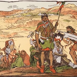
Before moving on to a discussion of the context in which this map was produced, let us examine the eight pictorial scenes depicted in the vignettes. These have been expertly engraved and fortuitously provided with a title that makes their content unmistakable. Moving clockwise from the upper left corner, we first see an image of eleven riders in full gallop across the prairie. Behind them a dramatic sky looms, echoing the title: ‘Fire on the Prairie.’ The riders are Native Americans, as is evident form their garb, headdress, and weaponry. Research has shown that fire was an important indigenous tool used by the tribes of the Great Plains to clear tall prairie grasses and drive Buffalo herds in a desired direction.

In the next scene we see six oxen drawing a heavy unmanned plough and a small farm in the background. The caption tell us it is a ‘Farming scene in Illinois.’ Further right, just above Lake Superior, we find an industrial scene with men on a large river raft conveying timber down river towards factories in the background. The caption reads ‘Raft on the Ohio River.’ One of the most dramatic vignettes is found in the upper right corner of the map, where we see a full vista of Boston with its crowded harbor and lofty architecture.
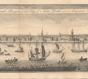
A scene in the lower right corner of the map is less idyllic, showing a group of what we must assume are slaves, toiling to clear cane fields. In the background a steamboat is depicted on what is likely the Mississippi River, confirming that we are in the deep south. Unlike all the other vignettes, this one has not been supplied with a title. Whether this is because of its content or because the title was cut away during the final trimming is unclear. To the left of the slave scene is another vista, this time of New York harbor as seen from Williamsburg. The last two scenes are more generic: one showing a ‘Western Scene’ with settlers, cabin and wagon; the second and last scene simply being entitled ‘Vintage Scene’ and showing settlers engaged in harvest.
Taken together, the scenes paint a picture of America as a rugged and beautiful country, slowly-conquered by the grit and determination of its people. This is especially true of the West, which is juxtaposed against the cities of New York and Boston; the difference between skylines, bridges, and factories on one side, and humble dwellings, oxen, and the gathering of firewood on the other side is clear and dramatic. Whether the mapmakers are trying to make a statement with the slave or the Native American vignette is difficult to assess.
Finally, there is a small inset in the lower left corner of the map, which depicts the nation subdivided by ‘Isothermal Lines and Zones of Equal Average Temperature’ — essentially an early type of climatic zoning. The inset is minor compared to the main map, but its purpose is perhaps to re-conceptualize America in a different way: Not just in political terms, as the main map does, but in a more longe durée perspective that reveals the country’s unity on a deeper level. A natural level.
Context is everything
The notion of one or more transcontinental railroads was of course much older than the Civil War. The Gadsden Purchase, extensively discussed in the description above, constitutes an obvious example of this. But it was as if with the war, the need — both on a practical and symbolic level — had been beset with a new urgency. And there was no place on earth like America for entrepreneurial men to heed this call (while of course scheming for the ensuing fortunes it would bring). Railroads had long connected people regionally, yet the prospect of any one firm taking on a continental crossing seemed a folly at first. But after the war, government support for the project was drummed up dramatically and incentives in the form of subsidies and mortgage bonds, as well as potentially massive land claims, were all highly enticing factors.
Essentially, it was private companies that would build on public land provided to them by extensive land grants. It would not be long before there was a veritable race across the prairie. From California, companies based in Oakland began entertaining their own notions of expansion and began planning how they could join the race by meeting their eastern counterparts somewhere in the middle. The first formal commission in this regard was the construction of 132 miles of rail between Oakland and Sacramento. From here, the Central Pacific Railway Company of California took over and constructed the almost 700 miles of track from Sacramento to Promontory Summit in Utah, where it linked up to The Union Pacific Railroad’s 1085 mile stretch from Council Bluffs in Iowa. By formally linking these two stretches on May 10th 1869, the first transcontinental railway had become a reality. By year’s end, the final stretch of this network was – from Sacramento to San Francisco – had also been completed.
In the process of constructing railroads across America, it was not just fortunes that were made and lost, but entire cities and peoples that either were elevated or perished. The story of the railroads’ drive west is one of epic proportions, which since has been commemorated and retold in numerous forms. It is the story of a wondrous, almost superhuman achievement, populated by visionary characters such as Theodore Judah, Thomas Durant, and Leland Stanford; and laced with pertinent symbolism. It was a dream come true; one that would affect every American across this great nation. It brought some people together, while it tore other people (and peoples) apart. As brutal, violent, and devastating as it was, especially for Native Americans, it was also one of the key phenomena that drove America’s impressive economic growth in the late 19th and early 20th century.
Within a decade of the first connection, transcontinental railroads had become the backbone of America. One thing was the physical and symbolic connection that they created, but what it really meant was that America’s immense bounty of natural resources could be efficiently harnessed and moved on to world markets. Ultimately, the engine that drove America’s industrialization was the locomotive.
Cartographer(s):
The Colton Mapmaking Company was a prominent family firm of cartographic printers, who in the nineteenth century were leaders in the American map trade. Its founder, Joseph Hutchins Colton (1800-1893), was a Massachusetts native who in 1830 moved to New York City and slowly began setting up his publishing business, which in the beginning drew heavily on licensing maps by established engravers such as David H. Burr, Samuel Stiles & Company, and later Stiles, Sherman & Smith. Smith was a charter member of the American Geographical and Statistical Society, as was John Disturnell. This connection would later benefit Colton, in that it helped him to acquire the rights to several important maps.
By the 1840s, the Colton firm were producing their own maps. They produced anything the markets desired, from massive and impressive wall-maps to pockets guides, folding maps, immigrant guides, and atlases. One of the things that set the Colton company aside from many of its contemporaries in terms of quality, was the insistence that only steel plate engravings be used for Colton maps. These created much more well-defined print lines, allowing even minute features and labels to stand out clearly. By 1850, the Colton firm was one of the primary publishers of guidebooks, immigration itineraries, and railroad maps in America.
In the 1850s, Colton’s two sons, George Woolworth and Charles B., were brought on board to the firm. This inaugurated a process of expansion in which the company began taking international commissions and producing wholly independent maps and charts. From 1850 to the early 1890s, they also published several school atlases and pocket maps. The firm continued until the late 1890s, when it merged with a competitor and then ceased to trade under the name Colton.
Condition Description
Superb original color. Dissected and laid on original linen. Overall an excellent example.
References
Ristow, Walter W. American Maps and Mapmakers: Commercial Cartography in the Nineteenth Century. Detroit, MI: Wayne State University Press, 1985; pp. 318-21.
![[AMERICAN REVOLUTION] Boston, George Washington, Franklin, Philadelphia, Washington, D.C.](https://neatlinemaps.com/wp-content/uploads/2024/05/NL-02090a_thumbnail-300x300.jpg)