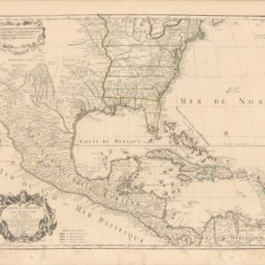
Mapping post-independence America: 1787 Le Rouge map of the East Coast and the Mississippi Valley.
Carte D’Une Partie De L’Amerique Septentrionale, pour servir a l’Histoire derniere Guerre
$1,400
1 in stock
Description
Published following the American Revolution, this interesting map covers the eastern part of North America from James Bay and the Great Lakes to the Gulf of Mexico, stretching east to the Appalachian Mountains. It presents the newly-formed United States in great detail, illustrating — as the title suggests — the original thirteen colonies which declared independence in 1776.
The map presents provinces, numerous towns and cities, forts, mines, rivers, Indian villages and tribal territory. It features two large and detailed inset maps, as well as a small inset view of Niagara Falls. The large inset at right is centered on the confluence of the Mississippi and Missouri Rivers, and delineates the Mississippi Valley and its tributaries, extending north to Lake Superior. The smaller inset at bottom shows New Orleans and part of the Gulf of Mexico, with West Florida.
Among the interesting state border configurations is the depiction of New Jersey, which extends far north into today’s New York.
The first state of this map was published in 1755. As the outbreak of the American Revolution increased demand for American maps, Le Rouge reworked the plate in 1777 (adding the boundaries of the new states) and re-titled it: Theatre de la guerre en Amérique. He then re-worked it again and published it in 1787 with the title Carte d’une partie de l’Amérique Septentrionale pour servir a l’Histoire de la dernière guerre (our map).
Cartographer(s):
Georges-Louis le Rouge (1707-90) was one of the most important French cartographers of Seven Years’ War and American Revolutionary War periods. He was born in Hanover, Germany, but moved to France in 1738.
Condition Description
Minor blemishes and wear at folds.
References
McCorkle, New England in Early Printed Maps; Sellers and Van Ee, Maps and Charts of North America and the West Indies.
![[AMERICAN REVOLUTION] Boston, George Washington, Franklin, Philadelphia, Washington, D.C.](https://neatlinemaps.com/wp-content/uploads/2024/05/NL-02090a_thumbnail-300x300.jpg)