Samuel Augustus Mitchell’s definitive chart of the American West: a quintessential guide for those drawn to the frontier.
A New Map of Texas, Oregon and California with the Regions Adjoining. Compiled from the most recent authorities
Out of stock
Description
Key points:
1. Samuel Augustus Mitchell’s seminal map of Texas, Oregon, and California was a decisive instrument in the great move West and one of the most influential maps in the history of American expansion.
2. It was one of the first commercial large-format pocket-maps of the regions beyond the Mississippi and features highly detailed routes for heading west. As such, it became an indispensable tool for the many immigrants, pioneers, and prospectors heading that way, including Mormon leader Brigham Young himself.
3. The map was produced during a rapidly-changing and exciting window of American history, characterized by new knowledge and shifting borders, exemplified by the territorial claims of Texas that extended both north and west, including Santa Fe.
Details
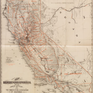
Samuel Augustus Mitchell’s map of the American West was indubitably among the most popular and detailed maps of the region prior to the incorporation of Oregon and California into the Union. But it is more than that. It represents the contemporary state of modernity reached in American cartography, and the rendition is so up-to-date that it fully incorporated events from just a few months prior. In many ways, Mitchell’s map came to define America’s understanding of itself, at least in geographic terms. It showed, in a very tangible way, how much had been accomplished by the fledgling American nation in just a few short decades, but it also manifested all that could still be achieved by those bold enough to endeavor.
The map was issued in 1846, on the eve of America’s first armed conflict with its newly independent neighbor, and only months after Texas had been lifted from its autonomous republicanism and into full statehood. As such, the map epitomizes a brief but highly formative period in the history of the United States and stands as one of the most iconic American publications to document the resolute forcefulness of westward expansion prior to the Mexican-American War (1846-48).
As indicated in the title, the chart covers the frontier territories of Texas, Oregon, and Upper or New California (i.e. including much of modern Nevada, Utah, and Arizona). While California and Oregon became hotbeds for development and industry in the latter half of the 19th century, it was the inclusion of annexed Texas that constituted the most obvious marker that here we had the most up-to-date chart available on the market. American settlers, known as Texians, had gradually moved into the region since the 1820s, and in 1836 they seized political power and declared Texas an independent republic. While the United States initially refused to accept Texas into the Union, the growing tension with Mexico eventually facilitated its historic incorporation. Even though Texas was not formally accepted as the 28th state until early 1846, it was the pre-conditional annexation that took place in 1845 which actually prompted Mexico’s invasion and the commencement of the Mexican-American War. We are, in other words, witness to a moment of extreme political tension, which within months will deteriorate into all-out war.
Mitchell’s map is clearly an American publication in that it is one of the first maps in history to depict Texas as an actual state rather than as an independent republic or part of Mexico. It also shows her claims to sections of the upper Rio Grande in present-day New Mexico. These claims were eventually abandoned as part of the Great Compromise of 1850, but in 1846 they remained highly pertinent. The Great Compromise was a set of laws dealing with the increasingly poignant issues of slavery and territorial expansion. As part of the legislation, California was admitted into the Union as a so-called ‘free state’ in which slavery was not tolerated, whereas the newly defined frontier territories of Utah and New Mexico were given autonomy to decide the question of their status for themselves. The laws also defined a new boundary between Texas and New Mexico and made the reclamation of fugitive slaves easier for southern landowners. In return for ceding the upper Rio Grande to New Mexico, the federal government agreed to assume the rather substantial public debt that Texas had incurred during its decade of independence as a republic.
As was stated in the booklet in which the pocket map was issued, Mitchell relied on the latest and best sources when compiling his map. These included, but were not limited to: Arrowsmith’s 1841 map of Texas, Wilkes’ map of Oregon from the same year, expedition maps from Frémont’s and Emory’s explorations of Utah and Texas, data from the Lewis and Clark expedition, and Joseph N. Nicollet’s map of the region between the Mississippi and Missouri. In other words, one would be hard-pressed to find a better and more accurate representation of the frontier territories in 1846 than Mitchell’s new map (see Context is Everything section).
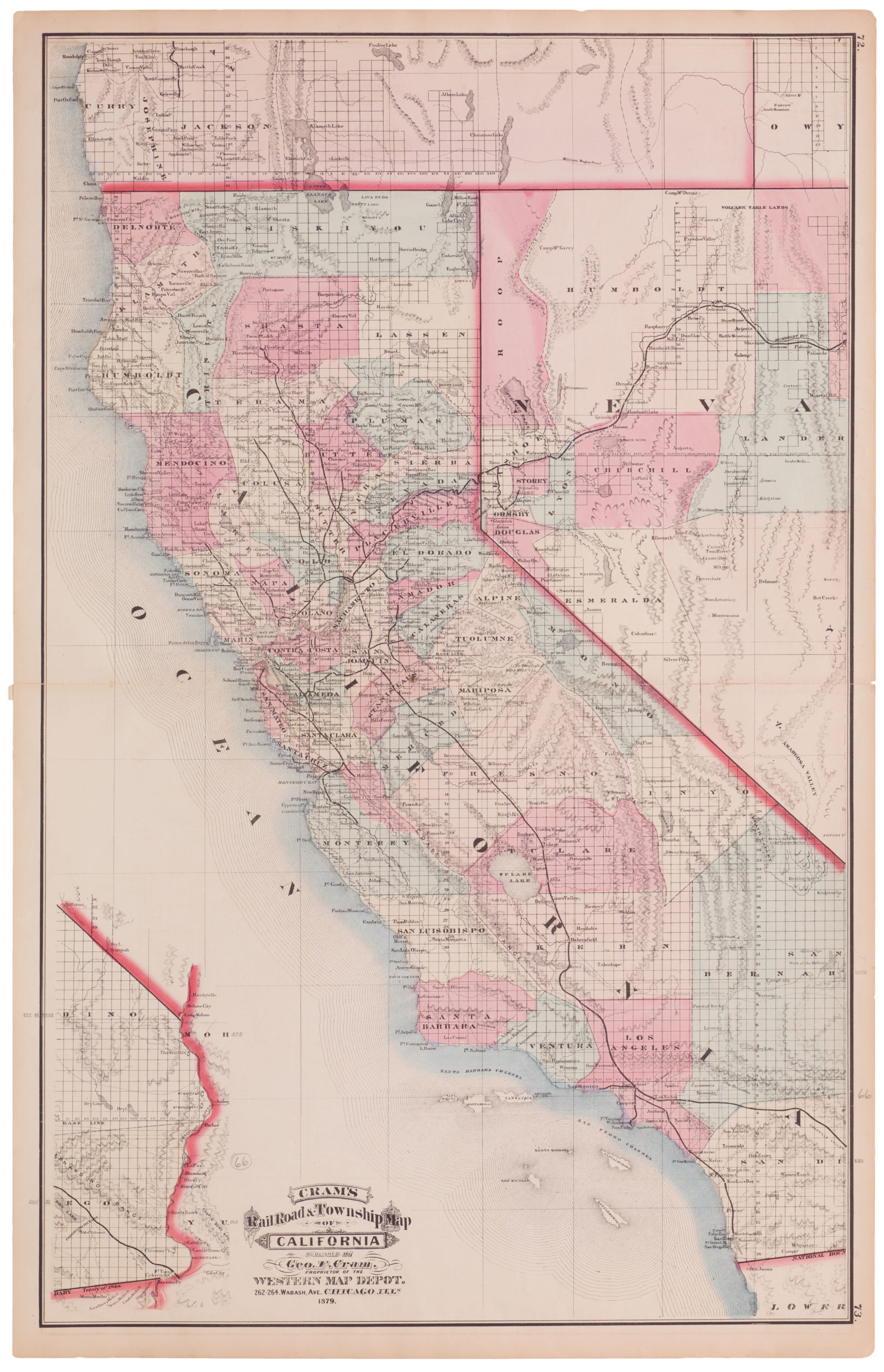
The map did indeed include all of the latest geographical knowledge and political developments. It showed what areas were still subject to strong Native American presence and the dangers associated herewith for pioneers, and it plotted out the established routes through the wilderness. An example of the latter is the ‘Oregon route,’ which extends from the border of the Missouri Territory, along the Platte and Snake rivers, and into Oregon, where it culminates at Oregon City (today a suburb of Portland).
Another more southern route also extends from the Missouri Territory. This was labeled the ‘Caravan route to Santa Fe’ to the east and the ‘Spanish Trail from P. Angelos to Santa Fe’ heading west and was an old trade route that connected northern New Mexico with Southern California prior to the establishment of railroads. Moving between the hubs of Santa Fe and Los Angeles was considered one of the most beautiful, arduous, and dangerous journeys that one could make in 19th-century America. Another route, El Camino Real de Tierra Adentro, extends south from Santa Fe into Mexico. Together, these routes constituted important corridors for the movement of American forces during the war with Mexico; after the war, they served as vital commercial highways.
The itineraries of early 19th century explorers have also been included on the map, most notably the routes taken by the MacKenzie (1793) and Lewis and Clark (1804-06) expeditions. Also worth noting is John Charles Frémont’s route through California. Frémont was an American officer, explorer, and abolitionist and the first presidential candidate for the Republican Party in history. He was colloquially known as ‘The Pathfinder’ and was a notable figure in the theatre of western exploration Between 1842 and 1844, Frémont explored the Rocky Mountains and Oregon interior by following the Oregon route west. From Oregon, he crossed into California before returning to his starting point in Westport, Missouri.
The map is filled with printed annotations to assist the user. Many of these pertain to natural or cultural conditions of a specific region and specify requirements, distances, or dangers on the route. In some cases, Mitchell’s reliance on contemporaneous sources becomes quite palpable, as is exemplified in the Great Interior Basin of California. This arid region, which stretches east-west basically from the Great Salt Lake to Lake Tahoe, has been filled in with commentary because the area is largely void of geographical data. In sharp contrast, the Sierra Nevada and Wahsatch ranges surrounding the basin have been depicted with a high degree of detail. This discrepancy of detail – the fine line between that which is known and that which is not – follows exactly the route that Frémont had taken only a few years earlier and reveals clearly one of the important sources for compiling this incredible chart.
The functional aspect of Mitchell’s map is further emphasized by the legend in the lower-left corner of the map. Under the explanatory text, we find a section entitled ‘Emigrant Route from Missouri to Oregon,’ comprising a formal guide to crossing into Oregon via the Rocky Mountains. Not only does it explain the process carefully, but it also provides a list of ‘…the reputed distances of the chief points of interest on the route.’ This highly practical measure allowed travelers to plan out their voyage in surmountable stages and constituted a huge logistical relief to larger groups. One such group, discussed in greater detail below, were the Mormons, who began their impressive trek west in the winter of 1846-47 and clearly made good use of Mitchell’s map.
The well-preserved contemporary hand color gives the map a strong visual impact, denoting political subdivisions and enhancing its characteristics. All of the borders have been clearly defined and, in many cases, annotated with the origin of that specific status. The map’s composition clearly relies on these territorial demarcations in that it has been compiled to cover exactly what it claims: namely, the entirety of Texas, Oregon, and California, as well as adjoining regions. The political climate in which the map was conceived stands out clearly from the fact that significant parts of both Mexico, as well the entire plains or so-called ‘Indian Territories,’ have been included in great detail.
Context is everything
Mitchell’s chart was originally published in two different formats: as an inset to a new edition of Mitchell’s large wall map ‘Reference and Distance Map of the United States’ (originally from 1834), and more importantly, as a foldable pocket-map. The latter, in particular, proved to be of huge importance for the shift west in that it became the most used and sought-after guide for immigrants and settlers traveling across the plains to reach their promised land. Consequently, a great number of these maps were issued, and a great number perished, used as they were in the field and not in stuffy but secure libraries on the East Coast. One of the famous expeditions that we know drew heavily on Mitchell’s map was Brigham Young’s great western migration in the winter of 1846 (Cohen 2002: 134-35).
That same year, Joseph A Stratton, a newly ordained Mormon minister, had only just returned from a mission to England. Yet his logistical skills soon landed him a role as Young’s right-hand man in preparing for this arduous journey. Preserved letters from Young’s hand to Stratton instruct him on a range of issues, but perhaps the most important is the order to acquire the latest and most precise maps of the frontier regions they were planning to enter. In doing so, Young writes: “I want you to bring me one half dozen of Mitchell’s new map of Texas, Oregon and California….” and continues, “…or rather the latest edition and best map of all the Indian countries in North America; the pocket maps are the best for our use. If there is anything later or better than Mitchell’s, I want the best” (Cohen 2002: 134). That it was Mitchell’s map the Mormons brought with them is demonstrated by the diary entries of another of the Mormon leaders. Albert Carrington had a keen interest in geography and was part of the Mormon expeditionary force that was sent to the great salt lakes of Utah in what came to be known as the Stansbury Expedition. Among his diary entries – both on the original journey west and during the expedition to the great lakes – we find constant references to the features and distances noted on Mitchell’s map.
Brigham Young was a pioneering frontiersman and an efficacious leader, but he was not a man to be crossed. He expected the same discipline and dedication from his followers that he practiced himself. Part of what made him so successful was his ability to organize his congregation and foresee the challenges that they would face on their famous trek across the prairie. But another element was his insistence on having the right tools for the task, and in the winter of 1846, there existed no better cartographic tool for their purpose than Mitchell’s detailed chart.
Cartographer(s):
Samuel Augustus Mitchell (1790 – 1868) was an American geographer and bookseller. During the middle of the 19th century, he became the dominant commercial publisher of geographic materials in America.
Mitchell worked as a teacher of geography before turning to publishing, but he found the materials available to students both antiquated and lacking, so he decided to abandon teaching in favor of producing geographic textbooks and maps. He quickly became one of America’s greatest cartographic publishers and played a decisive role in making Americans aware of their country’s geography.
Condition Description
Original hand-color. Backed on archival tissue repairing one clean tear into the image which enters the image near Iowa City, from the right edge, and continues west-northwest to the Canadian border near "Black Foot Indians."
References
Cohen, Paul E. 2002 Mapping the West. America’s Westward Movement 1524-1890. Rizzoli International: New York
Hayes, Derek 2007 Historical Atlas of California - with original maps. University of California Press: Oakland.