The first printed folio map of North America and the most iconic American chart of the 16th century.
Americae Pars Borealis, Florida, Baccalaos, Canada, Corterealis. A Cornelio de Iudaeis in luce edita.
$34,000
1 in stock
Description
Key points:
1. Cornelius de Jode’s 1593 “America Pars Borealis” encapsulates the European understanding of North America only a century after the voyages of Christopher Columbus.
2. With its singular focus on North America and its extensive notes, De Jode’s map has no contemporary equal. But more than that, it gives us a window into the compiling process of a cartographer working in a time of constant change.
3. The list of firsts or near firsts associated with this map is long and impressive: besides being the first printed folio map of North America, it makes one of the first references to the Apache Tribe, it is one of the first maps of the continent to name Virginia and the settlement of St. Augustine, to associate ‘Appalachian’ with the mountain range, and many more.
Introduction
Cornelius de Jode’s 1593 “America Pars Borealis” has rightfully become the quintessential early map of the North American continent. has rightfully become the quintessential early map of the North American continent. Compiled and printed a century after Columbus reached the New World, this map is a testament to the impressive scale of exploration that characterized the 16th century, as well as to the drive and genius of the cartographers who documented it. The map is a visual manifestation of the fearless and ruthless efficiency by which European powers and individuals penetrated this new and unknown world. At home, as demand for news about the New World’s treasures and dangers soared, mapmakers all over Europe, aided by the most recent reports, surveys, and manuscripts, were soon engaged in a competition to create the most informative, most accurate, and most evocative depiction of this virgin continent.
Cornelis de Jode compiled this chart for the revised version of his father’s atlas, Speculum Orbis Terrarum, which was originally published in 1578. Fifteen years later, and two years after his father’s death, Cornelis issued a revised version that he and his father had been working on for over a decade. Now entitled Speculum Orbis Terrae, this impressive folio atlas included both reissued versions of his father’s maps (e.g. Septentrionaliu regionum Svetiæ Gothiæ Norvegiæ Daniæ), as well as wholly new compilations drawn up independently by Cornelis.
The North America chart is one of these new additions and was among the seminal maps that have caused Cornelis de Jode’s atlas to stand out in posterity. However, because the atlas was issued in competition with the atlases of other famous mapmakers, such as Abraham Ortelius, its circulation and success were limited. Some years after its publication, the plates were acquired by fellow Antwerp publisher Jan Baptiste Vrients, who first prevented new printings and later destroyed the plates, to secure that no further editions of Speculum Orbis Terrae could be issued. Yet even though this map only exists in a minimal number of copies, rarity is not the only aspect that makes it so incredibly desirable among collectors and institutions. It is the nature of the rendition itself that is extraordinary.
Sources and contemporaries
One of the reasons this particular chart has become so celebrated is that it is a fascinating amalgamation of tradition and innovation, of cartographic aspiration and aesthetic vision, and as such, a perfect example of the transitional era of cartography that the 16th century represents. The map aims to depict, in as accurate a form as possible, all of the known elements of the New World. The East Coast littoral is beset with detail, labelling settlements, coves, inlets, rivers, and islands. While Native American toponyms are present, in most cases, the place names relate to European ‘discoverers.’ While such attributions might be seen as a cog in the wheel of colonial imperialism today, the use of these references was not just the standard mode of reference at the time, but also a means of underlining how well-researched and thus reliable the map was. It was the job of any good cartographer to ensure that he was familiar with the latest findings and reports, and when studying De Jode’s chart, we see that there is no doubt he lived up to that expectation.
The first cartographers to meet the challenge of depicting the North American continent in full were working from Italy, whereas De Jode was based in the Flemish port of Antwerp. Yet even measured against his Italian predecessors, Cornelis De Jode was a pioneer in the mapping of America, and both his innovations and mistakes are carried into new maps of America for almost a century. The only real continental chart to precede this one was the Paolo Forlani/Bolognino Zaltieri map from 1565, from which he no doubt drew both information and inspiration. Yet, on the whole, De Jode’s map is decidedly different than the Forlani/Zaltieri map, which depicts the entire west coast, but does not provide nearly the degree of detail that De Jode does, and which is entirely void of explanatory texts on the map itself. In his seminal The Mapping of North America, Philip Burden suggests that a more likely source of inspiration was the 18-sheet map produced by Petrus Plancius in 1592, at least regarding the continental outline. Another possible source was Theodor de Bry’s maps of Virginia and Florida, issued in 1590 and 1591, respectively.
The exact sources used for this map are, nevertheless, of some importance, as the De Jode map skews the North American landmass, causing a more than 5° northerly deviation along the east coast and generally warping the continent. Thus, we find an identifiable element such as Chesapeake Bay (Chesipooc Sinus) placed at the latitude of Maine and New Hampshire. Essentially, the problem that challenged De Jode was how to merge the geographical details extracted from French reports of eastern Canada and English surveys and reports on the Carolinas. Both of these great powers were already competing over ever greater swathes of land.

Consequently, many largely unexplored territories were claimed by both empires, and both used reports and maps as a vehicle for carrying their claim. When compared, the overlapping territories were consequently filled with inconsistencies, and the only way to overcome these inconsistencies elegantly was through skilled creativity. In De Jode’s case, he contracted the otherwise long coastal stretch from Maine to Virginia to a short east-west span culminating in Chesapeake Bay. Despite incorporating the reports of Giovanni da Verrazzano and others, there is no sense of the soon-to-be crucial promontories of Cape Cod, Long Island, New Jersey, or Delaware.
Title bar and northern regions
If we approach a description of the map systematically, we may begin with the large bar above the map itself. This has been divided into three sub-sections, of which the central title cartouche is the largest. Translated roughly from Latin, it reads: “North America, Florida, Newfoundland Island [Baccalaos], Canada, Newfoundland and Labrador [Corterealis]. Luminously made by Cornelis de Jode.” To its left, we find a second inscription dedicating the map to Julius Echter von Messelbrun, the prince-bishop of Würstenburg who funded parts of De Jode’s important work. The inscription crowns a simplified version of the Messelbrunn coat of arms, which is flanked by Cornelis’ name and the year of the map’s production (1593).

To the right of the titular cartouche, we find the first of many vivid illustrations on the map. The scene depicts a European caravel nearing a coast and firing its cannons towards two indigenous figures, who are attacking the vessel from the land with bow and arrow. De Jode uses this image as an aesthetic balancing mechanism for the title bar and presumably did not intend for it to have a deep, explicit meaning. Yet, Burden notes that the image depicts an attack on Martin Frobisher’s ship Gabriel during his expedition to find the Northwest Passage in 1576.
Immediately underneath the crowning bar, the map is visually dominated by a large and clear Northwest Passage, underlining how the enduring desire for such a route stimulated mercantile fantasies in Europe. The passage is entered in the western fringe of the map, through a strait separating Greenland and Labrador. Interestingly, a second strait further north hints at the Lancaster Sound passage first noted by William Baffin and Robert Bylot in 1616, but only confirmed by Edward Parry more than 200 years later.
On the western end of the map, the envisioned Northwest Passage empties into a large bay before extending off the map, with several large rivers flowing into it from the south. It is not entirely clear to what this large bay refers. Still, it may be an early rendition of the Hudson Bay, which hasn’t yet been “discovered,” but may have been a general concept known through hearsay from native reports to the French about northern cartography. De Jode may also have adapted the idea from earlier maps of the continent, such as Sebastian Münster’s Novae Insulae Nova Tabula from 1540, which includes a similar sea opening up to a northwest passage. However, Münster’s configuration is more aptly positioned in the western part of the continent.

Before delving into the many exciting features of the main continent, a few notes should be made on a large polar landmass or archipelago floating above the Canadian wilderness. While De Jode’s depiction is not dissimilar to geographic reality, his rendition is in many ways purely schematic, as he testifies by labelling it ‘INCOGNITA’. Several mountain ranges run along the coasts, but these too are more likely to be based on cartographic precedent rather than a reflection of any actual report or chart to which De Jode had access. Within each of the main islands, we find minor cartouches describing these lands as unexplored and intensely frigid, but neither entirely uninhabitable nor their waters unnavigable. The inscription on the right goes so far as to call it an ‘excellent island’ (‘Insula optima’).
Joāo Vaz Corte-Real (Corterealis), John Scolvus, and the Pining Expedition of the 1470s
The chart gains legitimacy by revealing some of the many voyages of exploration that informed its compilation. As a 16th-century map, all annotations are still written in Latin to lend the map greater status and applicability. The substantial swathes of text — especially in the interior, but also some off the east coast — mainly refer to voyages of discovery that have mapped the various regions, which in unison form the continental impression. Some of the referenced explorers are still celebrated today, for example, Giovanni da Verrazzano and Sir Walter Raleigh. Others, like Sebastian Cabot (John Cabot’s son), Jean Ribault, and the Danish expedition of John Scolvus and João Vaz Corte-Real (Corterealis), have largely been forgotten, but were pertinent during De Jode’s time. The references to the Scolvus/Corterealis voyage are perhaps the most interesting in this regard, in part because they figure prominently and repeatedly, and in part. After all, this is an expedition about which even many historians are unaware.
While the world generally acknowledges Christopher Columbus as the discoverer of America, most people are aware that Norsemen arrived in North America centuries before Columbus’ landing on Hispaniola. The Vikings established farming settlements in what they called ‘Vineland’ (present-day Newfoundland), but these did not survive for more than a generation or two. Likewise, the expedition of John Scolvus predates Columbus’ first voyage by almost two decades. Scolvus was a Danish (or possibly Polish) navigator in the service of Denmark’s King Christian I. During the 1470s, Christian instigated a formal collaboration between Denmark and Portugal to discover a western route to the Indies. This would cut out both the merchant cities of Italy and the powerful Queen Isabella of Spain — not to mention the multitudes of middlemen along the way — to the immeasurable profit of both nations.
Around 1473, the Danish King sent out a maritime expedition with the aim of discovering such a westerly route to Asia. At its head, he placed two German privateers, Didrik Pining and Hans Porthorst, who were accompanied by two experienced navigators: the Portuguese João Vaz Corte-Real (also written ‘Corterealis’) and John Scolvus. Several historical sources independently suggest that this expedition reached the shores of Newfoundland around 1475, although modern historians have questioned this notion, arguing that Greenland is a more plausible candidate. Portuguese sources from the late 1470s speak of a Terra Nova do Bacalhau (New Land of Cod) discovered by Corte-Real. In contrast, Gemme Frisius’ 1536 globe and a document associated with Frobisher’s first voyage in 1575 both mention a passage between Greenland and Terra Corterealis (Newfoundland?), which had been piloted by Scolvus in 1476.

To what degree these accounts have the full weight of history behind them is difficult to assess — indeed, debates over this contentious issue have raged for decades. What is important to note, however, is that De Jode’s map, like the Frisius globe, clearly uses both the toponyms and topography associated with the Scolvus expedition. This suggests that Scolvus may have been a more commonly known and accepted source in the 16th century. Thus, while modern scholarship has cast considerable doubt as to the veracity (or rather geographical accuracy) of Scolvus’ claims, this skepticism was not present in the late 16th century. De Jode’s map reveals that the reports of these now undervalued explorers were hugely influential in conceptualizing the new continent cartographically in the 16th century.
Giovanni da Verrazzano
While the results of the Corte-Real/Scolvus expedition remain somewhat obscured by the dark veil of history, the accomplishments of Sebastian Cabot, Giovanni da Verrazzano, and Walter Raleigh are broadly recognized as historical fact. For his part, Verrazzano was sent by King Francis I of France to explore the east coast of North America for a route to the Pacific. He made landfall near present-day Cape Fear, North Carolina, in early March of 1524 and headed north to explore. A narrow strip of land soon came into view, revealing a large stretch of open water on its opposite side. Verrazzano was convinced this body of water was the ‘South Sea,’ as the Pacific Ocean was known at this time. He proceeded up the coast, expecting at any moment to find a passage that led to the open sea. However, no such passage existed. What we know today is that Verrazzano had not discovered an ocean but rather Pamlico Sound, a large lagoon off the coast of North Carolina; the narrow strip of land was the Carolina Outer Banks. Nevertheless, the idea quickly made its way onto maps as a large sea extending into the North American continent, for example, the one seen on Münster’s map of the Western Hemisphere discussed above.
The discoveries of Giovanni da Verrazzano thus shaped the underlying geography of maps throughout the 16th century. He is understood to be the first European to survey the coastline between Florida and New Brunswick, including the bays of Narragansett and New York, as well as the coastline of New England and the Carolinas. He was also the first European to reach present-day New York, nearly eighty-five years before Henry Hudson (the Verrazano–Narrows Bridge in New York is named after him). Many of the place names included on our map — especially between Virginia and St Lawrence Bay — come from his extensive voyages in the 1520s.
While the annotation in the waters off present-day New England dates Verrazzano’s expedition to 1529, this probably refers to the date of his report, as he was killed and eaten by cannibals during his second voyage in 1528 (probably on the island of Guadeloupe). A similar minor chronological error is found in the annotation regarding Sebastian Cabot’s search for the Northwest Passage (noted as 1507, in fact 1508-9). In general, De Jode has relied heavily on the latest reports of exploration and discovery when compiling this chart. Citations regarding source information are present throughout the map and will be drawn upon as we proceed to describe its components.
New France
We see in De Jode’s map the beginnings of a colonial America. Many of the most crucial landscape features have been plotted by this time, including tentative depictions of its rivers and mountains. The density of place names along the East Coast has already been mentioned as impressive for the time, and toponyms are not limited to settlements, but also pertain to coves, points, estuaries, and other identifiable geographical phenomena. A similar density of toponymic annotations is found in the deep bay of St. Lawrence (marked ‘Sinu St Laurenty’), which De Jode already at this stage understands to be the most crucial linkage between the Atlantic coast and the Canadian interior. The bay continues to the St Lawrence River, which De Jode rather boldly extends southwest across the continent and into modern Texas.
By the late 16th century, the French had already laid claim to large swathes of land along the eastern seaboard. Their influence is evidenced by the label ‘NOVA FRANCIA’, written in the largest font on the map. Interior trade networks were widespread and well-developed in French Canada, particularly in the fur trade. Most of the goods accumulated in this great wilderness were subsequently carried to a network of waterways before being transported by river to a large Iroquois settlement located on an island where the rivers run into St. Lawrence Bay. Regarding trade, infrastructure, and defense, this settlement, labeled ‘Hochalaga‘ on the map, held an ideal position in the landscape.
De Jode’s naming and depiction of Hochalaga with a pictorial settlement follows earlier reports by Jean Jacques Cartier, who visited there in 1535. Between then and the publication of our map in 1593, dispersion, epidemics of European diseases, and intertribal wars appear to have had a devastating impact on the population, which dwindled precipitously over the course of the 16th century. By De Jode’s time, the settlement had not yet been entirely usurped by the French, as is indicated in the use of its original name, but by 1603 the original site had been abandoned altogether. Within seven years, the French established a new trading station on the island, which they named Montreal. During the 17th and especially the 18th centuries, Montreal became the central hub for the Canadian fur trade.

As he has done in other parts of the map, De Jode positions an annotation about this region not nearby, but where there is available open space. Thus, an account of the demographic composition of tribes occupying the region of St. Lawrence, Newfoundland, and Labrador, which describes the peoples as ‘benign and humane,’ is placed in California on the left side of the map. The comment supposedly pertains to the entire region between Florida and the land of Baccalaos — an enigmatic term also used in the map’s title. Baccalaos is a common toponym on 16th- and early 17th-century maps, but its placement and designation shift around. It is generally fixed to the northeast of the continent, and is associated with one or all of Nova Scotia, Newfoundland, or Labrador. On De Jode’s map, it refers to Newfoundland Island. But to muddle the issue further (especially given De Jode’s mentions of Cabot), we have come across an esoteric reference from the voyages of Sebastian Cabot who, after sailing south along America’s east coast, entered the Gulf of Mexico so ‘…as to have the island of Cuba on his left hand.’ Cabot supposedly named the coastal lands west of Florida ‘Baccalaos’ after the abundance of a large fish which the natives termed the same way (Notices respecting the voyage of Sebastian Cabot to the northwest, from Peter Martyr ab Algeria. in Kerr, 1811).
Lake Conibas
The Great Lakes have not yet come fully into cartographic focus by this time, although the map does include three smaller freshwater lakes in a region labeled ‘Saguenai’. There is also a river of the same name and an annotation that describes it as easily navigable. The entire composition reveals this region to be an amalgamation of ideas — a sort of cartographic mutation — in which the earliest reports of the Great Lakes and Sanguenay River (which in reality drains Lac Saint-Jean into the St. Lawrence Bay) have been conflated into a single idea.
Something similar seems to have happened slightly further west, where a large Lake labeled ‘Lago de Conibas‘ empties into the Arctic Ocean to the north. Although this lake is clearly a mythical creation, it is pretty standard on late 16th-century and early 17th-century maps of America, including examples produced as far away as China and Japan.

A significant source of the concept’s dissemination was Cornelis Wytfliet’s 1597 atlas Descriptiones Ptolemaicae Augmentum. This pioneering work included eighteen regional maps of America, of which one was the first map dedicated to the region around Lake Conibus. Without doubt, however, De Jode’s map also played a decisive role in fixing this idea in the minds of his European readers. Like Wytfliet shortly after, De Jode depicts the area as at least partially explored, suggesting that its depiction is based on actual accounts. An annotation immediately to the right of the lake, for example, states that the local peoples rely on fishing and fur-trapping for sustenance and clothing, suggesting some documented contact had been established. Another annotation to the west of the lake notes that even the Canadians affirm that they do not know the extent of this large, sweet water lake. Several settlements and rivers are also depicted west of the lake. A third annotation, located just north of the lake, describes the lands as perpetually covered in snow. While these commentaries give the impression of a relatively known area, all three are so vague that we must cast doubt on their accuracy.
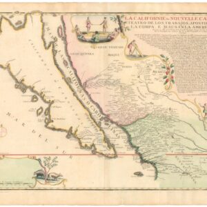
California and the Seven Cities of Cibola
Another compelling region on the map is Greater California, which has been correctly named and depicted as a coastal peninsula rather than an island (a trend that will soon become popular). The Gulf of California is named Golfo Vermelo (Red Gulf) by the descriptions provided by Hernán Cortés and his lieutenants. While the southern half of the Californian coastline is amply annotated with toponyms, demonstrating the strong Spanish presence here, they are, as one might expect, somewhat thinner as one moves further north. The place names are a mix of early Spanish designations and common 16th-century cartographic misconceptions. Some of them are written twice, for example ‘Capo del Engaño’ (‘Cape of Disappointment’ or ‘Deceit’), so named because it was at this latitude that Spanish explorers expected (and failed) to find the north end of the Island of California. Cedros Island also receives two designations. ‘Cazones,’ located between the two, refers to either the San Benito Islands or Natividad. De Jode has also followed earlier mistakes, for example, the placement of ‘Tiguex’ on the coast; this settlement, recorded by Coronado, is located in present-day New Mexico.
Multiple large rivers extend inland from the Gulf of California, several of which link up to mountain ranges. The most noteworthy is the Rio Coromara at the northern end of the Gulf, which extends into what will later become Arizona and New Mexico, only to culminate in a large lake surrounded by seven villages or settlements. The general area is labelled ‘CEUOLA’ and an annotation to the left of the villages refers to these as the ‘seven cities’ (‘Septem Citta’).

This entire scene refers to the legend of Cibola and the Seven Cities of Gold, an extremely popular myth in the 16th century and the aim of many a fortune-seeking conquistador. The origins of the myth are elusive, but it gained serious popular momentum thanks to Franciscan friar Marcos de Niza. De Niza was sent north from Mexico City by Viceroy Mendoza in 1538-39 to search for wealthy cities that were rumored to be somewhere past the northern frontier of New Spain. In early 1539, he left the frontier at Compostela and journeyed into the unknown for several months. In the summer of 1539, he returned and wrote a report stating that he had discovered the cities in a province called Cibola (the present-day native American pueblo of Zuni, New Mexico). He said he reached the first city and saw it from a distance, but because his companion had been killed there, he returned without entering it.
Most popular writers claim De Niza reported gold in Cibola. Still, his original report says nothing about gold (De Jode’s annotation reads: “Marcus Nizza asserts that the Province of the Seven Cities is very noble”). Nonetheless, the conquistadors in Mexico City were excited by his news and assumed Cibola would be as wealthy as the great cities of the newly conquered Aztec empire. This stimulated a frenzy of expeditions, none of which were successful in penetrating deep enough inland to locate any hidden towns. In 1540, De Niza led Coronado’s army back to Cibola, but he became the scapegoat when Cibola proved to have no golden cities, only numerous villages built of adobe.
Coronado’s soldiers accused De Niza of being a liar. Still, the allure of such myths and the lust for treasure nevertheless led to renewed pushes inland, which in turn provided fresh data, however spurious, for cartographers. De Jode’s chart is only the second time in history that Cibola is shown on the shores of an inland lake and with a direct reference to De Niza’s ‘noble’ observations marked on the map (the only earlier example being Richard Hakluyt’s map of 1587).
Finally, another interesting feature of the West in this map is the multiple mountain ranges that have been depicted pictorially. One range in particular is fascinating, long, and imposing enough to constitute an early conceptualization of the Rocky Mountains. While De Jode has this range running east-west rather than north-south, it is a particularly compelling feature because of its extension across the continent and because the mountains themselves seem to have been drawn larger than any of the other ranges depicted on the map. The warping of the map discussed above may have caused De Jode to mistakenly twist the northwestern quarter of the continent in a southwesterly direction, which in turn tilted the schematic representation of the Rockies to their current shape.
In an open space above the mountains, on the left side of the map, De Jode has provided several lines of text regarding Native peoples of the American Southwest. The annotation warns that the mountains are ‘inhabited by diverse nations, ferocious men without laws, who fight continually amongst themselves’. He goes on to list several tribes, including the ‘Apalchen,’ which modern scholarship considers to be one of the earliest historical documentations of the Apache Tribe, whose historical homelands have consisted of high mountains, sheltered and watered valleys, deep canyons, deserts, and the southern Great Plains, including areas in what is now Eastern Arizona, Northern Mexico (Sonora and Chihuahua) and New Mexico, West Texas, and Southern Colorado.
The Gulf of Mexico
The coastline of the Gulf of Mexico is another area that has been rendered with an impressive degree of detail. Inlets, coves, estuaries, and rivers have been labeled, and in the west, several Mexican settlements have been included on the map. De Jode’s map exhibits the distinct influences of some history’s most famous expeditions in the region, especially those of Spanish conquistadores Ponce de Leon and Hernando de Soto.
Ponce de León grew wealthy during his time as governor of Puerto Rico and became in effect a self-funded conquistador. He set out to explore new lands in 1513 with three ships in search of gold, silver, and slaves (the Fountain of Youth legend is a later invention). When he came upon the east coast of the Florida peninsula, he mistook it for an island. He named the land ‘La Florida’ because it was the Easter season, which in Spanish is Pascua Florida, “feast of flowers.” At about Cape Canaveral, the expedition turned south only to face a powerful current unlike any other they had previously experienced. This was the Gulf Stream, which would later serve as a maritime highway between Europe and North America, the Old and New Worlds.
In 1521, Ponce de León returned to Florida to establish a Spanish colony. The expedition landed somewhere on the coast of southwest Florida, likely in the vicinity of Charlotte Harbor or the Caloosahatchee River, areas which Ponce de León had visited on his earlier voyage to Florida. The would-be colonists were repelled by the native Calusa and Ponce de León was hit in the thigh with a poison dart and later died of his wound back in Cuba. This dramatic event finds its way onto our map in the form of a place name – Sinus Ioannes Ponce – in the area corresponding to Charlotte Harbor.
Despite the travails and demise of his predecessors, along came another Spanish conquistador in search of riches along the Gulf of Mexico: Hernando de Soto. The Soto expedition left Havana in May 1539 and landed most likely at Tampa Bay. They eventually made their way north to Apalachee, where they are said to have observed the first-ever Christmas in the present-day United States. In addition to Florida, Hernando de Soto and his men explored parts of Georgia, Mississippi, Arkansas, and Louisiana. The conquistador died of an unknown illness, and his body was placed into the Mississippi River, which was called the ‘Rio de Santo Spirito,’ as it appears on our map.

It appears that the Spaniards neither mapped the Mississippi nor understood its importance. For nearly two centuries after the Soto expedition, European explorers missed the entrance to the Mississippi from the Gulf. Part of the problem is hinted at on De Jode’s map: the explorers were looking for what they assumed would be a bay instead of a delta. The Mississippi Delta is so massive that it obscures the great river that feeds it. On De Jode’s map, the R. de S. Spirito empties into a large enclosed bay. Interestingly, the placement of the river and the wetlands of its delta is more accurate than maps that succeeded it, for example, Vincenzo Coronelli’s 1688 map of North America, which shifts the river too far to the west.
Florida and Virginia
The West is not the only region on this map to be endowed with new and vital information. We have already mentioned that much of the East Coast remained a terra incognita until the expeditions of Giovanni da Verrazzano (1522-24) and that the results of these voyages were meticulously incorporated onto this map. By the time De Jode compiled his map, this scenario had, of course, changed considerably. Especially in Virginia, around Chesapeake Bay, the Carolinas, and Florida, we find a plethora of towns and settlements named on the map. One of these is St. Augustine, making this the first printed map of North America to label the fort settlement — only the Boazio plan of St. Augustin and the Hogenberg map of the Western Hemisphere, both published together in 1589, preceded it.
In general, the toponyms reflect how the colonizing gambits of the French and Spanish had paid off. A note in this regard is found at the top of the continent. The text reminds the viewer that the French under Captain Ribault were the first to arrive in Florida in 1561 and that they built at least two forts (Charlesfort and Fort Caroline), but that these were captured by the Spanish in 1565. This is followed by a reminder that Captain Ribault “returned and destroyed the heretics.” This comment is critical because it reveals De Jode’s ideological aversion to Spain, which, until very recently, had governed the Netherlands with some brutality. Furthermore, the Dutch were not only free from Spanish rule, but they had also undergone a Reformation in which a Calvinist Protestantism had ubiquitously replaced Catholicism.
Further north, in areas such as Virginia and the Carolinas, the interior remains largely an unknown and inhospitable wilderness. The map conveys a sense that the frontier begins immediately inland from the town. And yet, De Jode manages to collect new data on these regions. A large text label, ‘Apalchen,’ has been misunderstood by many as a reference to the Apache Tribe, but it refers to the Appalachians. This toponym appears on earlier maps, but the connection De Jode draws between it and an impressive set of mountain ranges lends considerable significance to the label in the history of American cartography, as it is one of the first times the Appalachians are explicitly presented on a map.
De Jode’s chart is the first general map of North America known to us to use the place name “Virginia” — the works of Hakluyt (1587), Mazza (c. 1589), and Hogenberg (c. 1589) are all Western Hemisphere maps and extremely rare. Additional new information on greater Virginia is found in the inscription in the heart of the continent, just southeast of Lake Conibas. Its positioning here is only because the unknown nature of this region provided De Jode with the open space he needed to insert this long and essential text. At first glance, it is not much different than many of the other references to voyages of exploration and discovery, since it alludes directly to a North American expedition mounted (but not joined) by Sir Walter Raleigh. They set out in 1585 and founded the so-called colony of Roanoke (labeled ‘Roanoac’ on the map) on what is today the border of Virginia and North Carolina. The settlement never prospered and soon died out, in part due to a lack of enthusiasm and support from the Crown.
The inscription regarding the settlement is vital because it abounds with underlying intention and cause. It is worth looking at in full:

“About the region of Virginia. This region, which we call Virginia today, was discovered by Walter Raleigh in 1585. It is a region rich in aluminum, (grape)vines, iron, and timber; everything that is necessary, also fertile soils. The people are of modest stature and dress in deer skins, are armed with arrows, and have stockpiles of wood. They live in wooden huts in the vicinity of the sea. There are penalties for those who break the law.”
We must recall that the knowledge conveyed here hinges on events that were very recent when this map was produced. Not only was De Jode extremely well-informed, but he actively decided to include this particular piece of information prominently on his map. This is worth noting because it carries with it an underlying call for colonization, ironically coming from someone whose nation had only recently thrown off the oppressive yoke of the Spanish Crown. What De Jode is telling us is that not only are these lands rich in natural resources, but they are also proximal to Europe and with inhabitants who are both technologically inferior and law-abiding. Could a more poignant case regarding the New World’s potential be made? And what better people to create an empire in the New World than the industrious men and women of the free and Calvinist Netherlands?
De Jode’s call would soon be answered. In 1602, less than a decade after the publication of his map, the Republic of the Seven United Netherlands chartered a young and eager Dutch East India Company (Vereenigde Oostindische Compagnie or “VOC”) with the mission of exploring North America’s waterways for a direct passage through to the Indies. The VOC commissioned Henry Hudson to find a Northeast Passage in 1610, which resulted in his formative explorations of present-day Canada and parts of the northeastern United States, including, of course, Upper New York Bay and the river that now bears his name. In this way, De Jode’s encapsulates the height of 16th-century cartography, while at the same time standing on the cusp of the immense changes seen in the century that followed.
A final note should be made of the fascinating little inset in the lower right corner of the map, depicting six distinct kinds of Native Virginians. These have most likely been taken from Theodor de Bry, who in turn adapted them from John White’s reports. White was an English artist and amateur cartographer who joined the first Raleigh expedition (1578) and was later asked by Raleigh to set up the new Roanoke colony on Chesapeake Bay. White may even have been a part of Martin Frobisher’s expedition to find the Northwest Passage ten years earlier, but this cannot be unequivocally confirmed. What can be confirmed is that John White was a driven and extremely observant colonist. He was also quite an accomplished artist and was initially charged by Raleigh to ‘draw to life’ the inhabitants of the New World — a task which he pursued vigorously. Soon his reports became the key source of reliable knowledge of the region, as is evidenced both by De Bry’s reliance on them and by De Jode’s inclusion of White’s portraits on his most crucial map.
Greenland, Iceland, and…Frisland
At the northern end of the map’s eastern edge, we find three large islands. The northernmost is Greenland, correctly labeled and relatively well-represented (although skewed southwest like the rest of the map). Below it are two smaller, but still substantial islands. The larger one is labeled ‘Thule,’ the ancient Roman term for the ultimate north, but this is Iceland; toponyms such as Dirafjord, Jokulfjord, and Hola are known and mentioned in the Icelandic Sagas.
The lower island is more mysterious. Even though De Jode has filled it with named settlements to underscore its veracity, ‘Frislant’ is a phantom island commonly depicted just south of Iceland in maps of the North Atlantic dating between 1560 and 1650. Frisland may originally have pertained to the southern tip of Greenland, as recorded by the Norwegian and Icelandic whalers who would sail on her southern shores in the summer.
Context is everything
Cornelis de Jode was the son of another Antwerp-based mapmaker, Gerard de Jode, who published an essential and magnificent atlas in 1578 entitled Speculum Orbis Terrarum. Despite Gerard’s skill as a cartographer and the exquisite nature of his atlas, it was never a big commercial success. This was mainly due to the competition that De Jode faced. In Antwerp alone, he competed directly against another prestigious cartographer of the era, Abraham Ortelius. Not only did Ortelius manage to publish his atlas before Gerard De Jode, he was also an incredibly well-connected and shrewd businessman, and he used his power to delay the formal issuance of a privilege for De Jode’s atlas by almost a decade. By then, it was too late for his atlas to compete with that of Ortelius seriously and thus became a commercial failure.
Not giving up so easily, Gerard began working on an updated and elaborated edition of his atlas, but he died a few years before it was ready. His son Cornelis — who is likely to have been assisting his father for years at this point — took over and finished the monumental task. The revised atlas, now termed Speculum Orbis Terrae, was issued in 1593. Sadly, this also did not have much success on the market, despite being of the same superb cartographic quality as Gerard’s original atlas, and including several new and impressive charts compiled by Cornelis for this edition. These included maps of the Arabian Peninsula and Africa. Still, by far the most important additions were his emblematic depictions of North America, consisting of our beautiful folio chart and the smaller, more dubious depiction of the Pacific coast (Quivira Regnu).
The De Jode atlases were produced during a pivotal time in the history of cartography. Despite being commercial failures, the maps were instrumental visualizations that helped the field of cartography shift away from a schematic worldview anchored in Ptolemy and into a Renaissance view of the world —a world in which observation, verifiable data, and critical thought became the most influential drivers for compiling new maps. There were many reasons for this transition. Early scientific inquiries conducted from great courts across the globe, combined with the latest knowledge attained from numerous voyages of exploration, created a context in which both our inner and outer worlds expanded at an explosive rate. The discovery of the Americas and the return of European sailors to the Indian Ocean also facilitated this shift, as these large, open waters required a much more careful consideration of observable phenomena, such as magnetic declination.
The great 16th-century atlases and charts produced by Flemish, Dutch, and Italian cartographers, in particular, were instrumental in changing how we perceived and represented a world that, during this time, was in almost constant flux. It must have seemed as if the world was not only growing daily, but that it was changing its very nature and structure as we watched. What was once common knowledge was relegated to myth the next day. For a professional and competitive mapmaker, it must have been a daunting task to constantly seek and acquire new data and then adapt one’s geographic understanding and vision accordingly.
In many ways, cartography had been a somewhat stagnant discipline for centuries, the main innovations occurring within the sphere of portolan production. However, from the early 16th century, new developments began to emerge. Critical revisions and new observations from crossing the Atlantic created an atmosphere of experimentation and adaptation, in which some of the most spectacular and decisive maps in history were made, above all, this one. At the close of the century, it was not just the discipline that had changed, but indeed the understanding behind the discipline, which had transformed fundamentally. The root causes of these changes should, of course, be sought in the courage and determination of the great explorers. Still, it was the cartographers and compilers of the day who gave the new understanding a visual form, thus gradually integrating it into a broader consciousness of how the world worked.
Cartographer(s):
Gerard de Jode (1511-91) was a Dutch printer and mapmaker born in Nijmegen, but working from the metropolis of Antwerp. One of the most competent and reputable Dutch cartographers of the 16th century, he did not fare so well business-wise, as competition was stark and his mercantile sense perhaps not so shrewd. In 1547 he was accepted into the Guild of St Luke’s in Antwerp and began working as a publisher and printer. De Jode quickly gained recognition as an expert mapmaker in a city that was already renowned for its cartographic output. His greatest achievement was a magnificent two-volume atlas entitled Speculum Orbis Terrarum, which came out in 1578. The idea was to create an atlas that could compete with Abraham Ortelius’ hugely popular Theatrum Orbis Terrarum, which had been published to great acclaim only eight years earlier. Despite De Jode’s status and reputation, however, his atlas was not a commercial success. The lack of circulation in 1578 has had a lasting legacy today, as it is now one of the rarest and most sought-after atlases, with only about a dozen copies known to exist.
Despite this lack of commercial success (or perhaps because of it), Gerard began working on a new and revised atlas. For this task, he recruited his son, Cornelis De Jode (1568-1600), as an assistant, and together they compiled another outstanding and innovative atlas entitled Speculum Orbis Terrae, which was published in 1593. Sadly, Gerard de Jode died of old age a little less than two years before its publication, but perhaps he was spared the embarrassment of another commercial failure. Even though the new atlas contained both Gerard’s original maps, it also included several key revisions, and perhaps most importantly, a range of entirely new maps compiled by Cornelis himself.
Like their 1578 predecessors, these 1593 maps are also scarce, especially since after Cornelius’ death, the engraving plates were sold to his competitor, J. B. Vrients (who also owned the Ortelius plates), who assured the complete work was never published again. Thus, while numerous editions of Ortelius were published and survive today, only the 1578 and 1593 editions form part of the legacy of the De Jode family.
Condition Description
The map is a copperplate folio sheet measuring 56 by 41 centimeters (22 x 16.2 in) and features a crown watermark. Latin text appears on the verso. It has old coloring, including in the illuminated initial of the verso text, which has been lightly touched up at some point. The sheet shows very limited foxing and browning and is in an impressive, highly desirable condition. The printing is strong and well-margined, with no coloring having decayed due to oxidation.
References
Burden, Philip D. The Mapping of North America. Raleigh Publications, 2018, 81.
Hayes, Derek. Historical Atlas of California: with Original Maps. Vancouver: Douglas & McIntyre, 2007.
Kerr, Robert. A General History of Voyages and Travels to the End of the 18th Century, Volume 6. Edinburgh: J. Ballantyne & Co., 1811.