Rare 1933 pictorial map honoring Junipero Serra and depicting Monterey and surroundings, including Pebble Beach and Carmel Bay.
(Monterey Area, California.) Honoring the Memory of Fray Junipero Serra, Founder of the California Missions.
Out of stock
Description
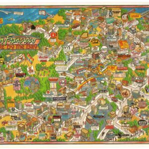
This evocative pictorial map from the 1930s provides a charming and detailed view of Monterey and its surroundings. It constituted an up-to-date map that included modern infrastructure and urban sprawl and has been overlaid with abundant pictorial and thematic references, primarily to the life and deeds of Father Junipero Serra (1715-1784). Serra was a Spanish Catholic priest and a member of the Franciscan Order credited with founding the first Mission settlements in California. Serra remains both a controversial and iconic historical figure who, despite objections from Native American groups, in 1988 was posthumously beatified by Pope John Paul II, and in 2015 even was canonized a saint by Pope Francis (more on Serra’s role in California history below).
While the map itself shows Monterey and its surroundings, including the settlements along Pebble Beach and down to Carmel Bay, its most enhancing features are all the vignettes, insets, and commentaries that carry the theme. Running along the top of the map is a series of iconic local buildings, which today constitute some of the state’s most important cultural heritage. Viewing these from left to right, we find the U.S. Customs House, Robert Louis Stevenson’s House, California’s first theatre, the house of Governor Juan Bautista Alvarado, Thomas Larkin’s house from his time as U.S. consul to Mexico (see context section below), and Colton Hall.
In the center of the top frieze, we find a larger vignette showing Father Serra’s landing in California in 1770. The frieze of important architecture continues down along the right flank of the map in immediate prolongation of Colton Hall. Here we have two additional images showing Pt. Pins Lighthouse and the Pacific Grove Museum. Two other vignettes adorn the map itself, depicting two of Father Serra’s famous missions. In Carmel Bay, we find the Mission San Carlos del Rio Carmelo, founded in 1770, the year Serra arrived in California. Further north, in Monterey itself, is the Royal Presidio Chapel, built in 1795.
An additional four insets are found in the lower right corner of the map. To the left is an elongated map showing the stretch of California coastline south of Carmel Bay and including Big Sur State Park. Piled one atop the next to the right of this map are an additional three views. The first shows Bixby Canyon Bridge, a single-span bridge that was one of the early marvels of American engineering. Below this is the entrance to the State Park at Big Sur River, in all its natural glory. And finally, at the bottom, a second, more detailed view of the Pacific Grove Museum.
A little inland, just south of the airport, are two text boxes. On the right is a simple table of distances from Monterey to nearby locations of interest. The larger box on the left provides viewers with a short text to contextualize the map historically. Without a shred of ironic distance, the following brief chronological overview is given:
‘Western Civilisation was founded on the Monterey Peninsula. The Bay of Monterey was discovered in 1542. Monterey was named by a Spanish explorer in 1602. In 1770 Padre Serra landed with his party. Mexico’s independence in 1822. The American conquest in 1846 made it part of U.S. soil. Constitution of California was written in 1849. Here stand the two old landmarks in the west San Carlos and Carmello Missions.
Two magnificent State parks, Point Lobos and Big Sur nearby, over one of the most scenic drives in the world’.
Context is everything
Starting in the late 18th century, Franciscan friars founded twenty-one missions along the coast of California between 1769 and 1823. The intention was to convert the native population to Catholicism and extend Spain’s colonial empire northward into the virgin territory that the pioneer settlers called Alta (Upper) California. The missions were built a day’s journey on horseback apart so that travelers could move safely between them, and they were usually positioned very carefully in the landscape. In many cases, a small contingent of Spanish soldiers would be stationed there alongside the Padres.
The route between the missions became known as the Camino Real (corresponding roughly to Highway 101 today). The missions also served as crucial infrastructure nodes in a wholly undeveloped and largely unexplored region of Spanish North America. Arriving in earnest during the late 1700s, Spanish settlers decimated the indigenous tribes through smallpox, servitude, and other depredations. Most of the Spanish settlements – be they the presidios built for the army, evolving pueblos, or indeed the California missions – gradually developed into some of the great West Coast cities (e.g. Los Angeles, San Francisco, San Diego, San Jose, etc.), which today make California the Nation’s most populous state.
Following Mexican independence in 1821, the missions were partly secularized. Twenty-seven years later, at the end of the US-Mexican War and with the signing of the Treaty of Guadalupe Hidalgo (1848), the California Gold Rush ensued, and in 1850 California achieved statehood. For a long time after this, the missions were largely forgotten and left to deteriorate as relics of a bygone era. However, in the 1870s and 80s, the ruined mission buildings regained some popularity, in part due to the enthusiasm propagated by writers like Mark Twain and Bret Harte. Increasingly they were viewed as part of California’s heritage, and particularly in Southern California, missions became cornerstones of a new regional identity.
While most people acknowledge them as an important part of California’s history today, there continues to be a valid critique of the “mission myth” as a historical narrative that omits uncomfortable truths.
Padre Junipero Serra
Junipero Serra was born in 1715 on the Balearic island of Mallorca. Upon completing his studies in Palma, Serra joined the Franciscan Order, where he also took the name Junipero in honor of one of St Francis’ most ardent followers. The following year, he was ordained a priest. After almost 20 years as a priest, Serra traveled to the New World, where he hoped to convert indigenous peoples to the true faith. He arrived in Vera Cruz on the Gulf coast and continued from here, on foot, to Mexico City. His mission took him to many different and often remote places throughout Mexico, where he gradually became a well-known and respected figure. In 1767, almost twenty years after his initial arrival in Mexico, Serra was appointed head of the Catholic missions in Lower California. Two years later, this responsibility was expanded to include Upper California. Moving north from Lower California, Serra arrived in the area of San Diego in the summer of 1769 and proceeded to found a mission there in mid-July. This would be the first of twenty-one missions founded by Franciscans along the Californian coast – a stretch of more than 600 miles!
Converting large numbers of indigenous peoples during his almost 35 years of missionary work, Serra was, in many ways, the key that opened California to external settlement. He was renowned for his sincere humility, deep faith, and diligent work ethic even during his lifetime. He was described as a man of an almost saintly character who deliberately avoided honors from the Church or other personal glory. Serra died in California in 1784, at the age of 70, but he is often credited as the man who instigated the colonization of California. Indeed the poster’s text states that he “…prepared the way for the coming of the white race, for the Argonauts, the covered wagons and the birth of the Golden State”.
Cartographer(s):
Jos. Smith was a mapmaker and artist active in the first half of the 20th century and focussed on the area of Monterey, CA. Little else is known about his biography.
Condition Description
Repairs along fold lines, upper and lower visible on verso. Water damage and wear visible.
References
Rumsey 8973.000.
![Flag Map of California [Signed in pencil by W.J. Goodacre]](https://neatlinemaps.com/wp-content/uploads/2022/01/NL-01134_thumbnail-scaled-300x300.jpg)
![Flag Map of California [Signed in pencil by W.J. Goodacre]](https://neatlinemaps.com/wp-content/uploads/2022/01/NL-01134_thumbnail-scaled.jpg)