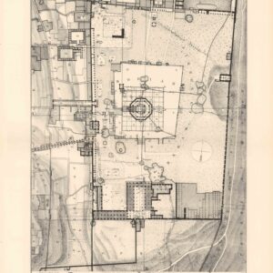
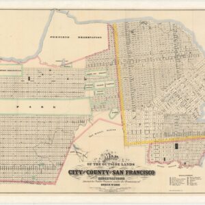
The first Ordnance Survey of Jerusalem and environs.
Ordnance Survey of Jerusalem. This Survey Was Made In The Years 1864-5 By Captain Charles W. Wilson R.E. and a Party of Royal Engineers From The Ordinance Survey. Under The Direction of Colonel Sir Henry James, R.E. F.R.S. & C. Director of the Ordnance Survey.
Out of stock
Description
The British Ordnance Survey of 1864-65 constituted the first scientific mapping of Jerusalem and its environs. It is a watershed map that lifted the charting of the Holy Land to entirely new heights. The young engineer in charge of the survey, Charles Wilson, would not just produce one of the finest Victorian maps ever made, but was instrumental in setting up the renowned Palestine Exploration Fund.
The 1864-65 ordnance survey of Jerusalem and its surroundings, conducted by the British Army’s Corps of Royal Engineers, was the first genuinely scientific mapping of the greater Jerusalem area. It is a highly accurate and detailed topographical map, superimposed with essential urban planning and infrastructure.
At the center of the map, we find the Old City of Jerusalem, which at this point constituted the majority of the Ottoman cityscape. The map provides an excellent level of detail within the city walls and in the surrounding countryside, testifying to the survey team’s meticulousness. Among the many features delineated, we find the city walls, distinct neighborhoods, roads within and without the urban enceinte, and individual buildings and complexes. The most important and iconic architecture, like the Haram al-Sharif (the holy Muslim precinct on the Temple Mount), the Holy Sepulchre (the location of Christ’s crucifixion and burial), the Muristan (Hospital of the Knights of St. John), and the Mamluk-Ottoman Citadel, have all been highlighted in red.
Unlike many contemporary maps of Jerusalem, the Ordnance Survey map uses local toponymy instead of the English place names. Thus the Aqsa is referred to as a masjed (Arabic for mosque), while the Dome of the Rock has its Arabic name, Khubbat as-Sahkra, as its primary label. This insistence on using local place names came from the missionary Carl Sandreczki and his two assistants, who compiled a long list of place names in local languages. The list included streets and roads, buildings, and a plethora of historical and religious landmarks, all of which were incorporated smoothly onto the map by the British survey team.
Within the city, the division of urban space among the various religious groupings is made palpably clear on the map. The center of Christian occupation was in the area around the Church of the Holy Sepulchre in the northwest part of the Old City. Jews lived around the foot of the Temple Western Wall, with their neighborhoods stretching westwards up the slopes of Mount Zion and towards the city’s Armenian Quarter. Finally, we find Jerusalem’s Muslim population living near the Haram al-Sharif and Mount Moriah in the northern and western parts of the Old City.
Outside the Old City, carefully plotted elevation lines provide a detailed topographic impression of Jerusalem’s hilly landscape. Essential pilgrimage points, lush valleys, and local villages are all properly labeled and delineated, including places like the Palestinian village of Silwan or the Mount of Olives. Plotted into the landscape, we also find cisterns, pools, and reservoirs (birket) prominently marked, underlining that the initial justification for allowing the British to conduct the survey was to improve the hydrological infrastructure that supplied the city and its many pilgrims with potable water. Northwest of the city is a large compound that has also been highlighted in red and is labeled “Russian Property.” This complex was built between 1860 and 1864 by the Imperial Orthodox Palestine Society and had been recently completed as a massive site for Russian pilgrimage. When Palestine came under British Mandate following World War I and the collapse of the Ottoman Empire, these facilities would become the seat of the Mandate administration, but this was still far off in the future when this map was published.
Census
The full report of the 1864-65 Ordnance Survey exists in a number of institutional libraries, including the University of Maastricht, the Atheanum in Deventer, the Rijksmuseum in Amsterdam, and the universities of Göttingen, Thüringen, and Leipzig (OCLC no. 712253661). Examples are also listed in the university libraries of London, Sheffield, and Glasgow and in the holdings of the National Libraries of Scotland, Denmark (OCLC no. 643578663), and Israel (Call no. L-IAA-ARC-044120).
A version of this map was originally published in the official Ordnance Survey report issued by Her Majesty’s Treasury in 1865. It was one of three survey maps included in the report, this one being at the largest scale (1:10000). The two other maps were drawn at a scale of 1.2500 and 1:500, respectively. Our sheet measures 49.5 x 49 cm (19.1 x 19.5 in), and in the upper left corner, we find the names of the royal engineers who worked on the survey. In addition to Charles W. Wilson, who led the survey team, James McDonald, Francis Ferris, John McKeith, John Davison, and Thomas Wishart are listed.
The present example is seemingly rarer than the report and may have been issued subsequent to the report for commercial purposes, as it was sectioned and backed on linen. While other dealers have noted copies of this version at the National Library of Israel, we have not been able to verify this independently. However, the library of the Hebrew University on Mt. Scopus does have an example of this map in their holdings (System no. 990020177550203701).
Context is everything
The Ordnance Survey of Jerusalem took place over the course of nine months between 1864 and 1865. It was the first time that a formal British Ordnance Survey was undertaken outside of the United Kingdom, and it also constituted the first scientific mapping of Ottoman Jerusalem and her environs. While it would hardly be misleading to ascribe imperial or colonial motives to the undertaking, the primary reason for initiating the survey was to ensure a clean and stable water supply to a city that increasingly was receiving European visitors – be they pilgrims, religious immigrants, or Victorian travelers. The survey was conducted by the Royal Engineers, who over the past decade had been incorporated into the British Army following the allocation of the Ordnance Survey to the War Department in 1855.
The project was primarily a private initiative, set in motion through an efficient collaboration between Lord Shaftesbury, Alexander McCaul of the London Jews’ Society, and James Finn, a former British consul in Jerusalem. Together they formed the Water Relief Fund in 1864 and began lobbying wealthy and influential socialites to fund a group of Royal Engineers to survey the ancient city. A 28-year-old engineer and officer, Charles William Wilson, was appointed to lead a team of six Royal Engineers (all listed on the map). Work began in early October 1864, and the survey was finally completed just under a year later, in June of 1865.
Despite being the survey’s primary objective, the team found no new sources of potable water. It is not entirely clear whether it was the paucity of new water sources that stimulated the shift in interest to more political matters, or it was the other way round. However, what is clear was that by the end of the survey, it had developed entirely different aims than when it started. Instead of the noble goal of supplying pious pilgrims with clean water, the survey now constituted part of an information-gathering exercise that eventually could lead to a more permanent British presence in the Holy Land, and perhaps even a complete take-over, should circumstances allow it.
Despite such imperial ambitions lurking in the background, the survey created the most comprehensive and accurate map of Jerusalem produced to date. Unlike Pierotti, who had gotten access to the Haram al-Sharif at a time when only Muslims were allowed, the British survey team managed to win access to the unexplored subterranean features of the Temple Mount. These investigations led to numerous discoveries, including an arch that once had supported a medieval bridge into the Haram al-Sharif complex. This arch can still be seen above the Western (or Wailing) Wall and still carries Wilson’s name. In addition to creating the first scientifically anchored map of Jerusalem and locating these ancient features of profound symbolic importance, the survey was also the first to ascertain the exact distinction between Mediterranean Sea levels and the Dead Sea depression.
In the end, the survey became the primary impetus for founding the Palestine Exploration Fund, which over the coming decades would survey and map extensive tracts of the Middle East, in part searching for evidence to verify the Biblical narrative. The PEF first convened in June of 1865, only weeks after the survey had been completed. At its head stood Charles Wilson. The PEF continues to be a decisive scientific presence in Israel/Palestine today.
Cartographer(s):
The Ordnance Survey was, and still is, the official National Mapping Agency in Great Britain. Founded in 1791 as the cartographic arm of the British Army, The Ordnance Survey was primarily responsible for mapping Great Britain itself. Yet as the British Empire expanded its holdings militarily, Ordnance Surveys were instigated at key locations throughout the world, often in collaboration with other governmental or semi-governmental bodies.
Condition Description
Segmented and laid on linen. Old German Library library stamp and shelf cancellation at bottom right.
References
Bahat, Dan 1980 "Introduction: The Ordnance Survey and its contribution to the study of Jerusalem” in Ordnance Survey of Jerusalem (Facsimile ed.). Ariel Publishing House: Chicago.
Foliard, Daniel 2017 Dislocating the Orient: British Maps and the Making of the Middle East, 1854-1921. University of Chicago Press: Chicago.
Glatt, Benjamin 2016 "Surveying Jerusalem" The Jerusalem Post (25 October 2016).
Schelhaas, Bruno, Jutta Faehndrich & Haim Goren 2017 Mapping the Holy Land: The Foundation of a Scientific Cartography of Palestine. Bloomsbury: London & New York.
![[Jerusalem Drawing]](https://neatlinemaps.com/wp-content/uploads/2023/05/NL-01488_thumbnail-300x300.jpg)