Jo Mora’s iconic 1945 map of California, “designed to help you keep the corners of your mouth on the up and up.”
California.
Out of stock
Description
Jo Mora was famous for his maps, and for good reason. He reinvigorated a century-old tradition of designing maps with the specific intention of prominent display, and then proceeded to fill these maps with his own personal cocktail of humor, knowledge, and skill. His typical style was that of a pictorial map, a genre most historians agree began with the Wonderground Map of London from 1914. By the time Mora was producing his maps, the genre was both established and very popular, often being in advertising.
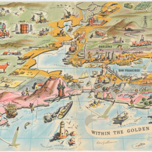
Mora was born in Uruguay, and despite growing up in Massachusetts, he was fascinated by the lifestyles and landscapes of the American West from an early age. Eventually, he settled in Carmel-by-the-Sea in California, and this is today viewed as his hometown. This excellent color lithograph from 1945, which measures 18.75 x 24.5 inches (on a sheet 22.25 x 28.5 in), depicts his adopted state of California in all its glory. It is the second California map by Mora’s hand and constitutes a whimsical and loving view of the state in its entirety.
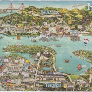
As is typical of Mora’s cartes, as he called them, one immediately notices the presence of pictorial, often caricatured elements throughout the map. Among the vignettes on the map itself, we find images of historical figures such as Sir Francis Drake and Juan Rodrigues Cabrillo – both famous 16th-century explorers that sailed on California. But the map also includes various local wildlife species, references to Native peoples, and essential natural landmarks like Yosemite and Mt. Whitney. Historical landmarks are featured in a series of individual vignettes along the left flank of the map (essentially in the Pacific Ocean). The locations consist primarily of California’s historical missions but also include a depiction of the Golden Gate Bridge and Oakland Bay Bridge in San Francisco.
Mora further augments the map by inserting an ingenious historical timeline in the upper right corner, consisting of a progression of human figures, from conquistadors to modern construction workers. Below the timeline anchored in human characters, we find a parallel reflecting the passage of time through a humorous depiction of vehicles, spanning from caravels and ox-drawn carts to private motorists and trans-Atlantic steamships. And the span between these naturally includes famous California icons such as prairie schooners and the Transcontinental Railroad. This use of personages and transportation to document some of the important developments in the state’s history is typical of Mora’s style and approach and part of the reason that his output resounded so broadly in the American public.
The whole map is a visual bombardment of layered information. Looking at it is an experience in which one constantly spots new elements and learns new things. But to find the passion that drove the man behind the map, we must look to the wonderful title cartouche in the lower-left corner. Designed as a tribute both to the State of California (represented by its Great Seal and California’s emblematic bear) and to the great mapmakers of yore (seen in the general composition and placement of the cartouche, as well as in details like the crowning compass rose), Mora uses this space to express his personal sentiments towards California. Rather than paraphrasing, let us give the artist himself the final word:
It is now past forty years since first I sifted into this glorious Eldorado of the West, forking the hurricane deck of a Sorrel pony. I had come a long trail and here was the Promised Land! It’s been my home range ever since. I’ve known here plenty grass – I’ve known it mighty short. That’s life. My wife and kids are native son and daughters and I feel I may sing in all truth and sincerity “I love you, California.” …Well, I’m strong for those souls who smile at their devotions: so, you see, I’ve tried to make this in a manner to help you keep the corners of your mouth on the up and up during the perusal of my CALIFORNIA.
A devoted adopted son, Jo Mora
Cartographer(s):
Joseph Jacinto “Jo” Mora (October 22, 1876 – October 10, 1947) was a polymath. He was a renowned illustrator, painter, muralist, sculptor, respected art historian, cowboy, and a pioneering ethnographic photographer.
Mora was born in Uruguay but emigrated with his parents to the United States when he was still a child. Settling on the East Coast, Mora went to art school in New York and later worked as a cartoonist for various newspapers in Boston. In 1903, Mora decided to leave the East Coast for California. He would not stay long, though, for the following year he moved again to Arizona, where Mora sought out Hopi and Navajo communities, with whom he settled for an extended period and learned about their languages and cultures.
As part of his work on Hopi and Navajo customs, Mora was one of the first outsiders to be allowed to document ceremonial events and specific individuals using a camera. His systematic effort to record the life and customs of these people is today one of the finest ethnographic collections on the Native tribes of Arizona.
In 1907, Mora was married and moved with his wife to California. Slowly building his career as an illustrator and graphic artist, he settled in Pebble Beach in 1922, where he established a large studio within his home. With his base now set, Mora illustrated a number of popular books, including Dawn and the Dons, The Romance of Monterey (1926), Benito and Loreta Delfin, Children of Alta California (1932), and Fifty Funny Animal Tales (1932). He also wrote three books himself: A Log of the Spanish Main (1933), Trail Dust and Saddle Leather (1946), and Californios (1949), which was published two years after his death.
Outside his work as an illustrator, Jo Mora is best known for his innovative approach to cartography. After moving to Pebble Beach, Mora began producing a range of attractive maps that drew audiences in with their combination of cartoons and reliable information. Among his more essential maps, we find Monterey Peninsula (1927), Seventeen Mile Drive (1927), California (1927 & 1945), San Diego (1928), Grand Canyon (1931), Yosemite (1931), Yellowstone (1936), Carmel-By-The-Sea (1942), and his Map of Los Angeles (1942).
Condition Description
Laid on poster linen for easier framing and display. Excellent.
References