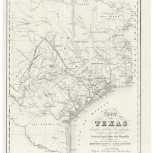
An unrecorded variant of Wyld’s monumental map of the United States and Republic of Texas.
Map of the United States and the Provinces of Upper & Lower Canada, New Brunswick, and Nova Scotia, Compiled from the Latest Surveys and Other Authentic Information.
Out of stock
Description
With an unusual Texas Western Border for which we find no parallels.
This is James Wyld’s large-scale map of the United States, published in London in 1841. It was issued in four finely-engraved sheets, then elaborated with original outline color and mounted on original cartographic linen.
Wyld’s map follows a distinguished cartographic pedigree. He constructed it on Walker’s excellent 1827 map of the United States, which itself was based largely on David Vance’s famous 1825 map, published in Philadelphia. Wyld significantly updated Walker’s treatment of Texas, inserting new towns like San Felipe de Austin, Harrisburg, and other place names around Galveston Bay.
For his part, Wyld published three editions of this wall map: 1839, 1841, and 1846. The editions are distinguishable from each other by the date beneath the title and divergences in the applied original outline color. All are scarce, but the 1841 issue is especially so, with no records of institutional holding in OCLC WorldCat and no trace on the private antiquarian map market.
The basis for three editions in such a relatively condensed period was the decisive events that occurred in Texas in the 1830s and the beginning of the 1840s. Indeed, comparing cartographic elements found on the 1839, 1841, and 1846 editions reveals how Wyld’s map embodies the complex political history of North America and offers a front-row seat to the processes that formed the United States and Mexico.
A western Texas border unlike any other
The most noteworthy feature on Wyld’s map involves Texas, which is actually depicted twice, once on the main map and once in a sizeable inset in the lower right corner. Focussing on the main map, we see that on the 1839 edition, for example this copy held by the University of Wisconsin Milwaukee, that Texas is shown as still part of Mexico. This depiction comes even though most of the fighting associated with the Texas Revolution was over years earlier, and the independent Republic of Texas was officially declared on March 2, 1836. It is also at odds with the inset map, in which Texas is outlined separately from the United States and Mexico.
The real intrigue comes with our 1841, on which a western border separates Texas from Mexico. We find no precedent for this border, which does not follow the Nueces River from the Gulf but instead traces the outdated eastern limits of the Mexican province of Nuevo Santander before cutting across to the Rio Guadalupe. From there, the border travels upriver until it meets the Rio Colorado, eventually jutting northeast to the Red River.
Where Wyld got this most unusual configuration is a mystery. He was plotting a new reality (the Republic of Texas) on outdated geography, thus affecting his understanding of its boundaries. Also, it is important to remember that western Texas at this time was a fluid and sparsely populated region, with three groups vying for control: Mexicans, Texans, and Comanches.
Diplomatic relations between England and the Republic of Texas
Two inconsistencies in Wyld’s cartography need to be explained:
- On the 1839 edition, the inset features a Texas outlined as independent from Mexico and America, but on the main map is still part of Mexico.
- On our 1841 edition, the borders of Texas depicted on the inset map and the main map are divergent. We see the standard configuration on the inset, which follows the Nueces River north to the Red River. This puts the inset at odds with the main map, the borders of which we have explained above.
The explanation for these differences is found in the diplomatic history of England and the Republic of Texas. England was later than many European nations to recognize Texan independence. The British wished to safeguard their trade with Mexico. Furthermore, England’s policy was to prevent the annexation of Texas to the United States; it was clear that independence would eventually lead to annexation. Ultimately, England only formally acknowledged Texan independence in the summer of 1842.
Wyld’s compositions are closely tied to this diplomatic timeline. As a fellow of the Royal Geographical Society and Geographer to Queen Victoria and Prince Albert, Wyld’s maps should be viewed as an extension of official British policy. Between the Texas Revolution of 1836 and its formal recognition in 1842, England employed an approach of strategic ambiguity to maintain its friendly standing with Mexico while at the same time increasing trade with Texas. This ambiguity is why Texas is not independent on Wyld’s main 1839 map. By 1841, British attitudes towards Texan independence were shifting (in part because peace between Mexico and Texas was now viewed as a possible path to avoid U.S. annexation). Wyld thus adds the new western Texas border on the 1841 edition, but it is the most favorable iteration for Mexico, England’s ally.
Clearly, for us at Neatline, this is a map that excites the historical senses. There can hardly be a better example of why studying maps is so attractive to both historians and collectors alike.
Census
Wyld’s map is a rarity. The 1839 edition (OCLC #557780797) shows two institutional records. The 1846 edition (OCLC #876879382) shows just one institutional record.
For the 1841 edition, we have not found any copies listed by OCLC, making this one of the rarest ‘Republic of Texas maps’ on the market.
Post-script: the 1846 edition
As mentioned above, subsequent to the 1841 edition, Wyld published another edition in 1846. We can consider this edition as the Mexican-American War issue.
To our surprise, while researching this map, two states of the 1846 edition came to light. Dorothy Sloan offered the first (what we call 1846a) in her Auction 10. We are limited by the poor quality of the available scan, but it appears that on the inset map, Texas is drawn as an integrated part of the U.S., with the western border maintained at the Nueces River, but that the main map border is similar to our 1841 map.
The second (1846b) was sold by Bonhams in 2012. The inset in this case includes several features unlike all previous editions: Texas has been incorporated into the U.S., including a western border along the Rio Grande; Post G. Hidalgo areas are delineated from Mexico and seemingly associated with the U.S., although not labeled. On the other hand, the main map is distinct from all previous editions in that Texas’s western border has been drawn clearly along the Rio Grande (Rio del Norte) rather than Nueces. This depiction suggests that the outline coloring was modified to reflect the results of the Mexican-American War.
Cartographer(s):
James Wyld (1812–1887) was a British geographer and map dealer based in London who had taken over his father’s business at Charing Cross in London.
In his own day, Wyld was best known for his so-called Great Globe, which was a popular attraction that dominated Leicester Square for more than a decade between 1851 and 1862. The enormous globe allowed people to climb an interior staircase and study a scaled topographic model of the Earth on the concave interior.
Above all, however, Wyld was a mapmaker who made his living compiling and selling maps throughout the western world. He also served as a Member of Parliament for Bodmin. In 1838, James Wyld married Anne Hester and their son, James John Cooper Wyld, would later take over the business and become a prolific mapmaker in his own right.
Condition Description
Four sections mounted, as issued, on original cartographic linen. Minor foxing and offset; Dutch National Archives ink stamp below title, their engraved inventory plate on verso.
References