Promoting California and the Gold Rush to a Receptive Audience.
A New Map of the State of California, the Territories of Oregon & Utah…
$675
1 in stock
Description
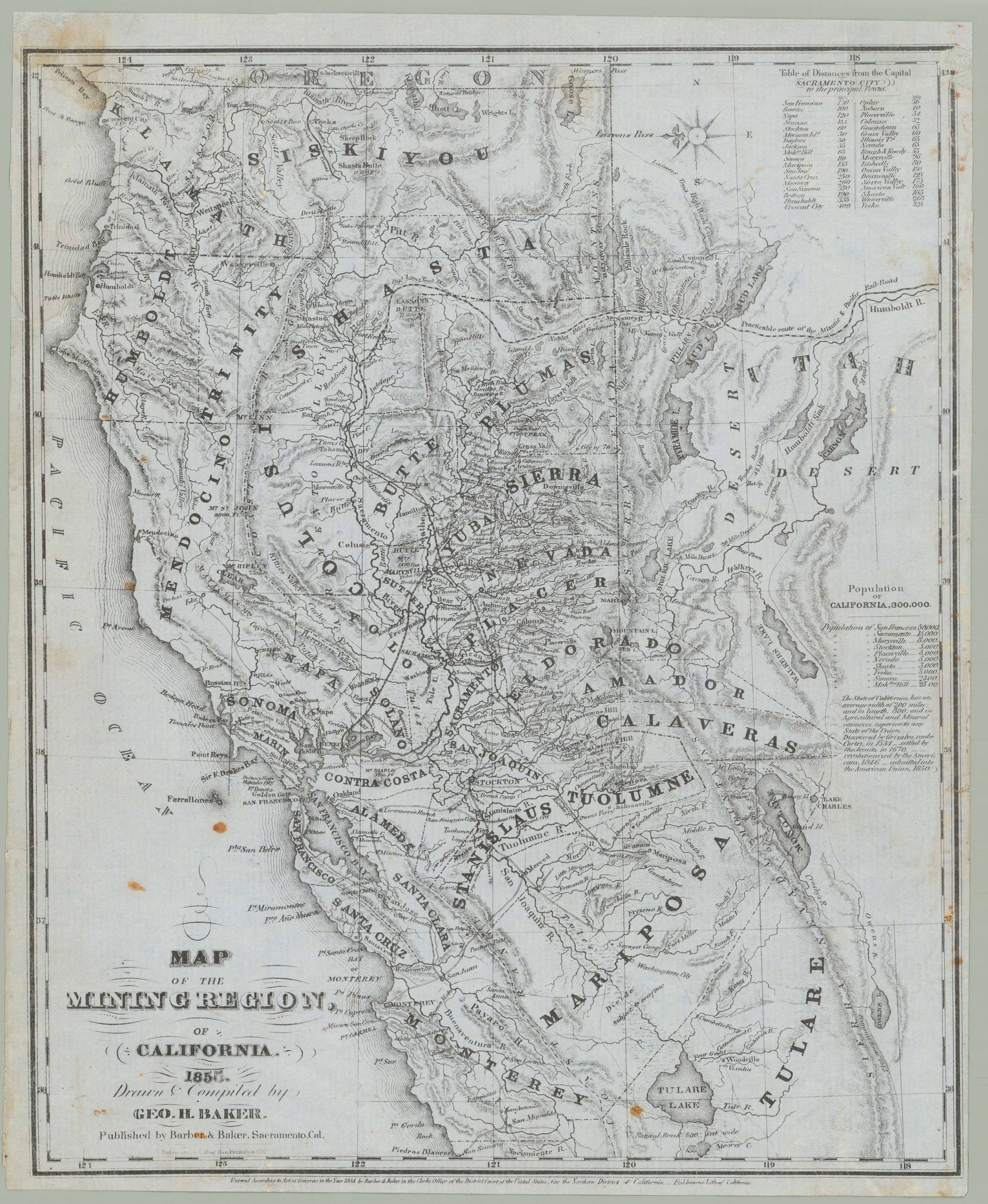
A curious map of the American West in the wake of the Gold Rush and the Mexican-American War, this work appeared in the 1852 edition of Joseph Meyer’s Hand-Atlas. It offers a snapshot of the region in a period of drastic change while also reflecting a particular interest in the opportunities offered by the Gold Rush in German-speaking lands.
The state of California is displayed along with the territories of Oregon, Utah, and New Mexico, without the additions made through the Gadsden Purchase, which was executed just after this map’s publication. Cities and town, mountains, waterways, forts, Native American groups, wagon routes, and other features are labeled throughout.
Germans were an important contingent in the multinational group of migrants who flocked to California after the discovery of gold there in the late 1840s. Gold was certainly a pull factor, but push factors were important as well, namely the failure of the Revolutions of 1848 in German-speaking lands. German liberals were keen to flee the conservative backlash throughout Europe and a new life in California afforded an excellent opportunity to do so. As an active and vocal supporter of the 1848 movements, as well as a trusted purveyor of geographic and other forms of scientific knowledge, Meyer had access to an audience that would have been eager for information about California.
That being said, this map is unusual among Meyer’s output in that it is in English instead of German; this is likely due to its cartographic sources, which surely included Samuel Augustus Mitchell’s famous Gold Rush-era map of the American West. But Meyer expands on Mitchell’s map by including an inset of the San Francisco Bay, Sacramento, and Stockton at bottom-left, that is, much of the gold country that had made international news in the preceding months. He has also included additional information, most noticeably towns, rivers, and other features in California, as well as Native American groups throughout the newly-acquired American territory.
In addition to the difficulties of working with a map in a foreign language, Meyer and his colleagues also printed steel-plate engraved maps rather than lithographs, as Mitchell had. Therefore, aside from intentional changes, some inadvertent can be seen between Mitchell’s and Meyer’s map, such as ‘Owen L.’ instead of Owens.
Cartographer(s):
Joseph Meyer (May 9, 1796 – June 27, 1856) was a German businessman and publisher of maps and atlases. After an active early career in business, which included early investments in railways, Meyer founded the publishing house Bibliographisches Institut in Gotha in 1826, which moved to Hildburghausen two years later. Initially, the publisher focused on reliable sellers like Bibles and encyclopedias, but gradually moved into maps and atlases and became especially known for its ‘Meyer’s Groẞer Hand-Atlas.’ After Joseph’s death, his son continued the business and continued to find great success, moving to Leipzig in 1874, with periodic bumps in the road due to wars and economic crises. The company survived both world wars and was divided along with Germany, but after 1991 moved back to its original location in Leipzig. In 1984, the company merged with a competitor to form Bibliographisches Institut & F. A. Brockhaus AG, which survives today.
Condition Description
Toning and some wear along edge.
References