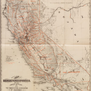
An early, large-format highway map of California.
Official Highway Map of California, Oregon, Nevada
Out of stock
Description
An impressive and fascinating large-format early highway map of California, drawn and published around the year 1930.
Roads are indicated according to their status as paved, improved, or unimproved/dirt roads. Towns and cities are labeled, while stretches of road between them denote the distance in miles. Lakes and major rivers are also represented.
The map serves as a reminder of both the lack of paved roads connecting the American West in the early 20th century and the rapid construction of highways in the 1920s and 1930s to remedy this situation. Still, the prevalence of dirt or unimproved roads, especially in Nevada and rural areas of California and Oregon, is readily apparent. The course of today’s CA S.R.-99 and U.S.-101 are clearly noticeable, along with portions of Interstate-5.
This map was drawn by Bashful Smith and published by the W.C. Eubank Company in San Francisco. Using the national parks and paved highways noted here as a basis, the map likely dates from c. 1930, and certainly before 1933, when a paved portion of highway was completed from the Oregon border to Red Bluff. However, as the highways are not labeled, the map may predate the institution of the U.S. Highway System in 1926. We are unable to locate any other examples of this map in institutional collections or on the market.
Cartographer(s):
Condition Description
Very good. Some wear along fold lines, especially centerfold. Toning and occasional spots of discoloration along edge.
References


![Flag Map of California [Signed in pencil by W.J. Goodacre]](https://neatlinemaps.com/wp-content/uploads/2022/01/NL-01134_thumbnail-scaled-300x300.jpg)
![Flag Map of California [Signed in pencil by W.J. Goodacre]](https://neatlinemaps.com/wp-content/uploads/2022/01/NL-01134_thumbnail-scaled.jpg)