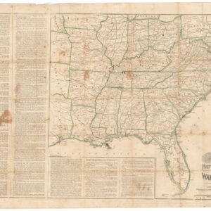
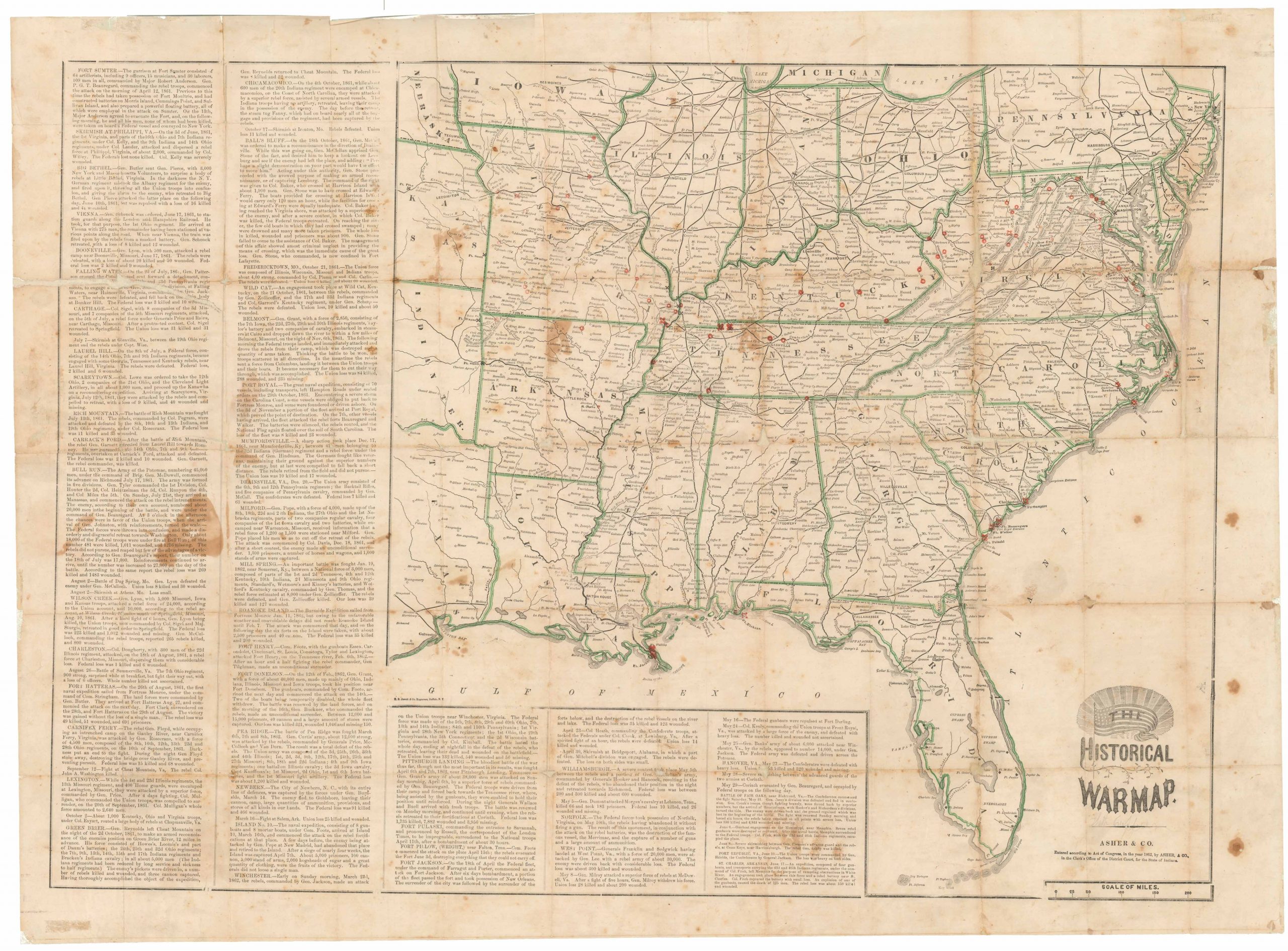
A mid-19th century Florida land survey map published a decade after statehood.
D. Diagram: of Tampa Land District.
Out of stock
Description
This is an official Florida Land Office survey map depicting the Tampa Land District and covering an area stretching from the Florida Keys and the everglades north to Merritt Island. This would also include today’s Chassahowitzka Wildlife Refuge.
The map was published in 1855, just a decade after Florida became the 27th state of the United States of America. Darker days were just around the corner, however: within just six years, on January 10th, 1861, Florida would secede from the Union in response to the election of Abraham Lincoln as President.
Cartographer(s):
A. Hoen & Co. was a lithographic printing company established in the 1840s by Edward Weber (as E. Weber & Co). Headquartered in Baltimore, the company rose to prominence under the leadership of August Hoen. After Weber’s death, Hoen assumed company control and rebranded the firm as A. Hoen & Co. His dedication to excellence and innovation propelled the company to become a driver of the American lithography and printing industry in the mid-19th century.
In addition to building the company, August Hoen is famous for pioneering the litho-caustic method. Patented in 1860, this revolutionized etching techniques using citric acid and gum arabic blend. This allowed lithographers to monitor the development of shaded patterns as they were etched onto the stone. Hoen’s relentless pursuit of refining shading techniques led to multiple patents granted in 1880 for methods to produce halftone prints via lithography. In 1877, the company gained recognition at the Centennial Exposition with “The Continentals,” a print created by Hoen’s litho-caustic process. It earned a commendation from the expo judges for its excellence in chromo-lithographic art.
Albert Hoen, August’s son, continued in his father’s footsteps and made significant contributions to the field, excelling as a printmaker and overseeing a laboratory dedicated to lithographic limestone testing. He conducted rigorous experiments and test runs with stones from promising new locations, furthering the company’s commitment to innovation and quality.
General Land OfficeThe General Land Office (GLO) was the independent government agency in charge of public lands. Created in 1812, it took over responsibility for public domain lands from the Department of the Treasury. Hitherto, the Treasury had done a decent job of overseeing the many surveys that were needed to map the lands of the Louisiana Purchase, including those taking place in the Northwest Territory. However, as land was added to the United States at an impressive rate in the 19th century, the government needed a new agency dedicated to surveying and planning the new lands. The establishment was a huge success, and over time the GLO would become responsible for surveying, mapping, and selling most of the land west of the Mississippi (except Texas).
In 1849, the GLO came under the auspices of the Secretary of the Interior, an office created that same year. Here it stayed until the creation of the Forest Service more than half a century later (1905). This made sense, since the GLO had been the office responsible for managing forested lands that had been extracted from the public domain, but remained the property of the State.
In addition to managing and selling land, the GLO conducted large scale surveys and produced maps and plans of the areas in question. In 1946, the GLO merged with the United States Grazing Service to become the Bureau of Land Management.
Condition Description
Beautiful hand color. Edge unevenly cut, some wear along fold lines.
References