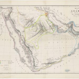
A particularly beautiful example of Sanson’s influential map of the “3 Arabias.”
Carte des Trois Arabies. Tiree en Partie de l’Arabe de Nubie, en Partie de Divers autres Autheurs…
Out of stock
Description
Rare map of the Arabian Peninsula, first published in 1654 and one of the first large maps focused specifically on the Arabian Peninsula. Sanson’s map of the Arabian Peninsula continued to influence maps of the region throughout the latter part of the 17th century.
Arabia is divided into three regions: Arabie Petree, Arabie Deserte, and Arabie Heureuse. There is great detail of mountains and rivers, although there are clear geographical errors, such as the exaggerated extent of the mountain ranges. Numerous villages are depicted, including stopping places on the pilgrimage to Mecca (Iathreb, Badrahenen, Gioffa, and Cadaid, among others), as well as towns that appeared for the first time on a map of Arabia (Hagair, Hadrama, Salamia, and Iamama). Bahrain is also delineated.
The map was engraved by Jean Somer and is adorned with a large columnar style title cartouche.
Nicolas Sanson was to bring about the rise of French cartography, although the fierce competition of the Dutch would last until the end of the century. His success was partly owing to the partnership with the publisher Pierre Mariette. In 1644 the latter had purchased the business of Melchior Tavernier, and helped Sanson with financial support in producing the maps. In 1657 Pierre Marriette died, however his son, also named Pierre, co-published Les Cartes Générales de toutes les parties du Monde the following year. It was the first folio French produced world atlas.
Cartographer(s):
Nicolas Sanson d’Abbeville (1600-67) was perhaps the greatest cartographer of 17th century France — a period of France’s political ascendancy in Europe and also a period in which French cartographers displaced the Dutch as Europe’s leading map makers.
As a young man, he attracted the attention of Cardinal Richelieu and, in time, became Géographe Ordinaire du Roi for Louis XIII and Louis XIV, both of whom he personally instructed in geography. Under Louis XIII, Sanson became a minister of state. Sanson has become known as the “father of French cartography,” and his influence is such that the sinusoidal projection he employed has become known as the “Sanson-Flamsteed projection,” recognizing the impact of Sanson (Flamsteed was an English astronomer royal from 1675 to his death in 1719).
Condition Description
Very good and dark impression. Two very small worm holes in lower part filled in. Very fine to mint condition.
References
Tibbetts, G. R. Arabia in Early Maps. Ney York, NY: Oleander Maps, 1978, 98.
Ankary, p. 98, 60. Couto, 61. Pastoureau, Sanson V [6]
![[Arabian Peninsula] Tabula Sexta de Asia.](https://neatlinemaps.com/wp-content/uploads/2024/03/NL-02008-NEW_thumbnail-300x300.jpg)